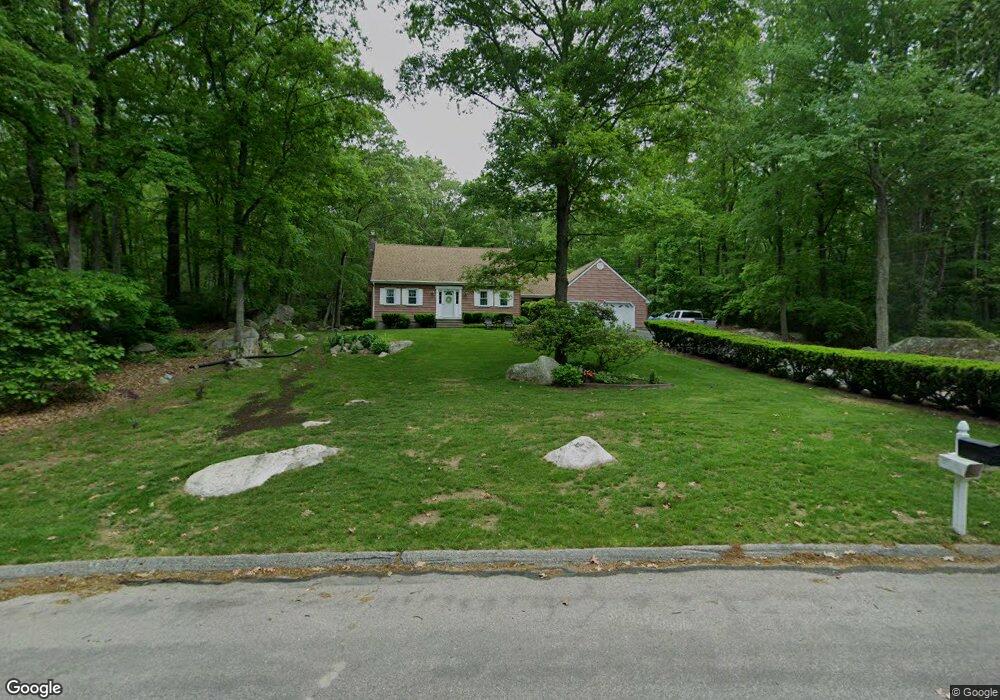
12 Devonshire Dr Gales Ferry, CT 06335
Estimated Value: $382,000 - $448,000
3
Beds
2
Baths
1,671
Sq Ft
$242/Sq Ft
Est. Value
About This Home
This home is located at 12 Devonshire Dr, Gales Ferry, CT 06335 and is currently estimated at $405,165, approximately $242 per square foot. 12 Devonshire Dr is a home located in New London County with nearby schools including Ledyard Middle School, Ledyard High School, and Academy Of St Therese.
Ownership History
Date
Name
Owned For
Owner Type
Purchase Details
Closed on
Jun 6, 2016
Sold by
Mandeville James T and Mandeville Donna T
Bought by
Mandeville Brian J and Fruth Julie M
Current Estimated Value
Purchase Details
Closed on
Aug 19, 1988
Sold by
Despres Dorval
Bought by
Argento Guiseppe
Home Financials for this Owner
Home Financials are based on the most recent Mortgage that was taken out on this home.
Original Mortgage
$50,000
Interest Rate
10.32%
Create a Home Valuation Report for This Property
The Home Valuation Report is an in-depth analysis detailing your home's value as well as a comparison with similar homes in the area
Home Values in the Area
Average Home Value in this Area
Purchase History
| Date | Buyer | Sale Price | Title Company |
|---|---|---|---|
| Mandeville Brian J | -- | -- | |
| Argento Guiseppe | $189,500 | -- |
Source: Public Records
Mortgage History
| Date | Status | Borrower | Loan Amount |
|---|---|---|---|
| Previous Owner | Argento Guiseppe | $100,000 | |
| Previous Owner | Argento Guiseppe | $100,000 | |
| Previous Owner | Argento Guiseppe | $30,000 | |
| Previous Owner | Argento Guiseppe | $50,000 |
Source: Public Records
Tax History Compared to Growth
Tax History
| Year | Tax Paid | Tax Assessment Tax Assessment Total Assessment is a certain percentage of the fair market value that is determined by local assessors to be the total taxable value of land and additions on the property. | Land | Improvement |
|---|---|---|---|---|
| 2025 | $6,219 | $167,440 | $52,290 | $115,150 |
| 2024 | $5,896 | $167,440 | $52,290 | $115,150 |
| 2023 | $5,787 | $167,440 | $52,290 | $115,150 |
| 2022 | $5,663 | $167,440 | $52,290 | $115,150 |
| 2021 | $5,626 | $167,440 | $52,290 | $115,150 |
| 2020 | $5,390 | $154,140 | $54,810 | $99,330 |
| 2019 | $5,404 | $154,140 | $54,810 | $99,330 |
| 2018 | $5,285 | $154,140 | $54,810 | $99,330 |
| 2017 | $5,016 | $154,140 | $54,810 | $99,330 |
| 2016 | $4,917 | $154,140 | $54,810 | $99,330 |
| 2015 | $4,686 | $154,140 | $54,810 | $99,330 |
| 2014 | $4,810 | $160,860 | $54,810 | $106,050 |
Source: Public Records
Map
Nearby Homes
- 123A Whalehead Rd
- 0 Clarks Falls Unit 24089817
- 7 Briarwood Ct
- 2 Garden Ct
- 16 Marty's Way
- 5 Bittersweet Dr
- 47 Norman Dr
- 18 Marty's Way
- 11 Marty's Way
- 25 Marty's Way
- 39 Ash Dr Unit 9
- 421 Kitemaug Rd
- 16 Marlene Dr
- 5 Ledgewood Dr
- 15 Drawbridge Rd
- 3 Holdsworth Rd
- 9 West Dr
- 165 Massapeag Rd
- 170 Depot Rd
- 932 Long Cove Rd Unit TRLR 4
- 13 Devonshire Dr
- 10 Devonshire Dr
- 14 Devonshire Dr
- 7 Devonshire Dr
- 8 Devonshire Dr
- 19 Devonshire Dr
- 4 Ravenwood Row
- 6 Devonshire Dr
- 5 Devonshire Dr
- 23 Devonshire Dr
- 4 Devonshire Dr
- 22 Devonshire Dr
- 6 Ravenwood Row
- 168 Whalehead Rd
- 27 Devonshire Dr
- 158 Whalehead Rd
- 154 Whalehead Rd
- 24 Devonshire Dr
- 29 Devonshire Dr
- 159 Whalehead Rd