Estimated Value: $37,000 - $217,000
Studio
--
Bath
1,780
Sq Ft
$62/Sq Ft
Est. Value
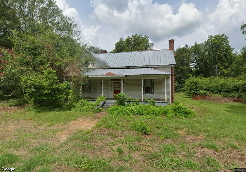
About This Home
This home is located at 12 Ga Highway 127 E, Mauk, GA 31058 and is currently estimated at $109,515, approximately $61 per square foot. 12 Ga Highway 127 E is a home with nearby schools including Taylor County Primary School, Taylor County Upper Elementary School, and Taylor County Middle School.
Ownership History
Date
Name
Owned For
Owner Type
Purchase Details
Closed on
Mar 20, 2023
Sold by
Peoples Bank Of Georgia
Bought by
Roberts John Daniel
Current Estimated Value
Purchase Details
Closed on
Nov 16, 2012
Sold by
Foster Bobby J
Bought by
Goggins Beverly L and Goggins Robert M
Home Financials for this Owner
Home Financials are based on the most recent Mortgage that was taken out on this home.
Original Mortgage
$27,000
Interest Rate
3.4%
Mortgage Type
New Conventional
Purchase Details
Closed on
Apr 22, 2009
Sold by
Foster Bobby J
Bought by
Mitchell Patsy
Purchase Details
Closed on
Jan 11, 1996
Bought by
Foster Bobby
Create a Home Valuation Report for This Property
The Home Valuation Report is an in-depth analysis detailing your home's value as well as a comparison with similar homes in the area
Purchase History
| Date | Buyer | Sale Price | Title Company |
|---|---|---|---|
| Roberts John Daniel | $31,000 | -- | |
| Goggins Beverly L | $30,000 | -- | |
| Mitchell Patsy | -- | -- | |
| Foster Bobby | $23,000 | -- |
Source: Public Records
Mortgage History
| Date | Status | Borrower | Loan Amount |
|---|---|---|---|
| Previous Owner | Goggins Beverly L | $27,000 |
Source: Public Records
Tax History
| Year | Tax Paid | Tax Assessment Tax Assessment Total Assessment is a certain percentage of the fair market value that is determined by local assessors to be the total taxable value of land and additions on the property. | Land | Improvement |
|---|---|---|---|---|
| 2025 | $313 | $14,920 | $4,000 | $10,920 |
| 2024 | $262 | $21,920 | $3,840 | $18,080 |
| 2023 | $340 | $15,160 | $3,320 | $11,840 |
| 2022 | $370 | $16,120 | $3,320 | $12,800 |
| 2021 | $394 | $16,760 | $2,760 | $14,000 |
| 2020 | $398 | $16,760 | $2,760 | $14,000 |
| 2019 | $404 | $16,760 | $2,760 | $14,000 |
| 2018 | $529 | $21,960 | $2,760 | $19,200 |
| 2017 | $502 | $21,094 | $3,382 | $17,712 |
| 2016 | $505 | $21,094 | $3,382 | $17,712 |
| 2015 | -- | $19,772 | $3,382 | $16,390 |
| 2014 | -- | $15,708 | $3,758 | $11,950 |
| 2013 | -- | $16,810 | $3,758 | $13,051 |
Source: Public Records
Map
Nearby Homes
- 15 Georgia 127
- 0 Brannon Montgomery Rd Unit 25510431
- 375 Village Ln
- 3742 Georgia 240
- 62 Brannon Montgomery Rd
- 221 Flamingo Dr
- 65 Saddle Trail
- 2450 Fort Perry Rd
- 656 Bridle Path Ln
- 000 Bridle Path Ln
- 0 Miller Rd Unit 25510377
- 0 Miller Rd Unit 25510378
- 115 Watermelon Ln
- SR-240 Connector
- Moores Chapel Rd
- 0 Moores Chapel Rd Unit 25510371
- 766 Parks Rd
- 0 Montgomery Rd
- 322 Moores Chapel Rd
- 0 Georgia 240
- Tract 5 Highway 127
- 0 Sidney Rustin Rd Unit 20067746
- 8 Walls Rd
- 11 Mauk Church Rd
- 1930 Ga Highway 90 W
- 25 Edward Green Rd
- 21 Walls Rd
- 865 Evergreen Church Rd
- 35 Edward Green Rd
- 49 Mauk Church Rd
- 45 Edward Green Rd
- 30 Mauk Church Rd
- 1971 Ga Highway 90 W
- 4176 Ga Hwy
- 4176 Ga Highway 127
- 782 Evergreen Church Rd
- 817 Evergreen Church Rd
- 1825 Ga Highway 90 W
- 138 Ga Highway 127 W
- 54 Mount Zion Church Rd
Your Personal Tour Guide
Ask me questions while you tour the home.