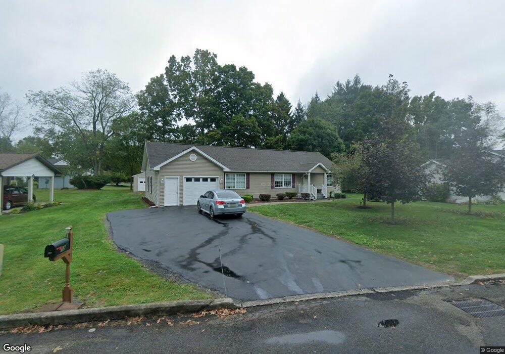
12 Garside St Mansfield, PA 16933
Estimated Value: $247,000 - $306,412
3
Beds
4
Baths
1,776
Sq Ft
$152/Sq Ft
Est. Value
About This Home
This home is located at 12 Garside St, Mansfield, PA 16933 and is currently estimated at $270,603, approximately $152 per square foot. 12 Garside St is a home located in Tioga County with nearby schools including Warren L. Miller Elementary School, North Penn-Mansfield Jr./Sr. High School, and New Covenant Academy.
Ownership History
Date
Name
Owned For
Owner Type
Purchase Details
Closed on
May 8, 2012
Sold by
Carleton Robin K
Bought by
Simpson Kenneth E and Simpson Victoria A
Current Estimated Value
Purchase Details
Closed on
Jan 10, 2011
Sold by
Carleton Robin K and Carleton Mari Jill
Bought by
Carleton Robin K
Purchase Details
Closed on
Aug 7, 2009
Sold by
Graver Keith G and Graver Sylvia B
Bought by
Carleton Robin K and Carleton Mari Jill
Home Financials for this Owner
Home Financials are based on the most recent Mortgage that was taken out on this home.
Original Mortgage
$160,000
Interest Rate
5.19%
Mortgage Type
New Conventional
Create a Home Valuation Report for This Property
The Home Valuation Report is an in-depth analysis detailing your home's value as well as a comparison with similar homes in the area
Home Values in the Area
Average Home Value in this Area
Purchase History
| Date | Buyer | Sale Price | Title Company |
|---|---|---|---|
| Simpson Kenneth E | $225,500 | None Available | |
| Carleton Robin K | -- | None Available | |
| Carleton Robin K | $28,500 | None Available |
Source: Public Records
Mortgage History
| Date | Status | Borrower | Loan Amount |
|---|---|---|---|
| Previous Owner | Carleton Robin K | $160,000 |
Source: Public Records
Tax History Compared to Growth
Tax History
| Year | Tax Paid | Tax Assessment Tax Assessment Total Assessment is a certain percentage of the fair market value that is determined by local assessors to be the total taxable value of land and additions on the property. | Land | Improvement |
|---|---|---|---|---|
| 2025 | $4,674 | $248,340 | $27,000 | $221,340 |
| 2024 | $6,614 | $248,340 | $27,000 | $221,340 |
| 2023 | $4,596 | $138,090 | $18,900 | $119,190 |
| 2022 | $4,549 | $138,090 | $18,900 | $119,190 |
| 2021 | $4,499 | $138,090 | $18,900 | $119,190 |
| 2020 | $4,476 | $138,090 | $18,900 | $119,190 |
| 2019 | $4,456 | $138,090 | $18,900 | $119,190 |
| 2018 | $4,386 | $138,090 | $18,900 | $119,190 |
| 2017 | -- | $138,090 | $18,900 | $119,190 |
| 2016 | $4,213 | $138,090 | $18,900 | $119,190 |
| 2015 | -- | $138,090 | $18,900 | $119,190 |
| 2014 | -- | $138,090 | $18,900 | $119,190 |
Source: Public Records
Map
Nearby Homes
- 11 Garside St
- - Townview Dr
- 0 Cherry Ridge Dr
- 28 Sherwood St
- 44 W Elmira St
- 342 Smoke Rise
- 72 Saint James St
- - S Main St
- 120 S Main St
- 175 Saint James St
- 2141-2165 S Main St
- 0 Fourth St
- Lot 14 Buckrun Rd
- 209 Mulberry Ln
- 16547 Route 6
- 101 Hemlock Dr
- 62 Canoe Camp Creek Rd
- 18789 Route 6
- 877 Odell Rd
- 2313 Pennsylvania 660
- 10 Garside St
- 14 Garside St
- 40 Wakefield Terrace
- 9 Garside St
- 20 Wakefield Terrace
- 8 Garside St
- 16 Garside St
- 7 Garside St
- 50 Wakefield Terrace
- 10 Wakefield Terrace
- 60 Wakefield Terrace
- 6 Garside St
- 5 Garside St
- 45 Wakefield Terrace
- 303 Extension St
- 200 Wakefield Terrace
- 70 Wakefield Terrace
- 55 Wakefield Terrace
- 4 Garside St
- 165 Wakefield Terrace