


12 Klasson Ln Weymouth, MA 02188
Weymouth Landing NeighborhoodEstimated payment $4,106/month
Highlights
- Medical Services
- Wooded Lot
- 1 Fireplace
- Property is near public transit
- Ranch Style House
- No HOA
About This Home
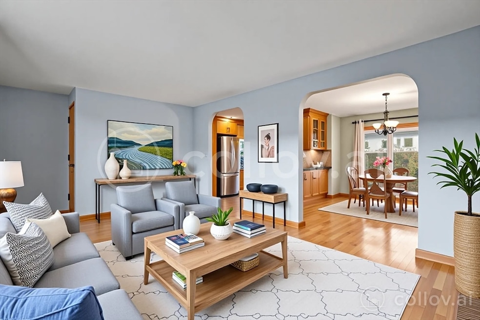
Beautifully updated 3-bedroom, 1.5-bath ranch offering 1,224 sq ft of comfortable living space on a quiet cul-de-sac in one of Weymouth’s most convenient neighborhoods. A charming covered front porch welcomes you inside to gleaming hardwood floors throughout and a bright, updated eat-in kitchen featuring granite countertops, stainless steel appliances, and a breakfast bar. The modern full bath complements spacious bedrooms. A screened-in porch invites you to relax and enjoy views of the expansive backyard with mature plantings and a vegetable garden. The huge full basement offers endless possibilities for additional living space, workshop, or gym—with existing plumbing for a full bathroom and bulkhead access. Located near Weymouth Landing, close to the new library, restaurants, commuter rail, and recreation areas including beaches, parks, and trails. Comfort, modern updates, and classic New England charm—truly a place to call home.
Home Details
Home Type
- Single Family
Est. Annual Taxes
- $5,788
Year Built
- Built in 1955
Lot Details
- 10,082 Sq Ft Lot
- Wooded Lot
- Property is zoned R-3
Parking
- 1 Car Attached Garage
- Open Parking
- Off-Street Parking
Home Design
- Ranch Style House
- Concrete Perimeter Foundation
Interior Spaces
- 1,224 Sq Ft Home
- 1 Fireplace
- Basement Fills Entire Space Under The House
Bedrooms and Bathrooms
- 3 Bedrooms
Location
- Property is near public transit
- Property is near schools
Utilities
- Forced Air Heating and Cooling System
- Heating System Uses Oil
- Water Heater
Listing and Financial Details
- Assessor Parcel Number M:21 B:287 L:023,275064
Community Details
Overview
- No Home Owners Association
- Near Conservation Area
Amenities
- Medical Services
- Shops
- Coin Laundry
Recreation
- Community Pool
- Park
- Jogging Path
Map
Home Values in the Area
Average Home Value in this Area
Tax History
| Year | Tax Paid | Tax Assessment Tax Assessment Total Assessment is a certain percentage of the fair market value that is determined by local assessors to be the total taxable value of land and additions on the property. | Land | Improvement |
|---|---|---|---|---|
| 2025 | $5,788 | $573,100 | $226,000 | $347,100 |
| 2024 | $5,723 | $557,300 | $215,200 | $342,100 |
| 2023 | $5,394 | $516,200 | $199,300 | $316,900 |
| 2022 | $5,354 | $467,200 | $184,500 | $282,700 |
| 2021 | $4,844 | $412,600 | $184,500 | $228,100 |
| 2020 | $4,636 | $388,900 | $184,500 | $204,400 |
| 2019 | $4,437 | $366,100 | $177,400 | $188,700 |
| 2018 | $4,299 | $343,900 | $169,000 | $174,900 |
| 2017 | $4,062 | $317,100 | $161,000 | $156,100 |
| 2016 | $3,933 | $307,300 | $154,800 | $152,500 |
| 2015 | $3,696 | $286,500 | $147,700 | $138,800 |
| 2014 | $3,630 | $272,900 | $137,500 | $135,400 |
Property History
| Date | Event | Price | List to Sale | Price per Sq Ft |
|---|---|---|---|---|
| 11/20/2025 11/20/25 | For Sale | $689,000 | -- | $563 / Sq Ft |
Purchase History
| Date | Type | Sale Price | Title Company |
|---|---|---|---|
| Deed | -- | -- | |
| Deed | $360,000 | -- | |
| Deed | $108,000 | -- | |
| Deed | -- | -- | |
| Deed | -- | -- |
Mortgage History
| Date | Status | Loan Amount | Loan Type |
|---|---|---|---|
| Previous Owner | $342,000 | Purchase Money Mortgage | |
| Previous Owner | $108,000 | Purchase Money Mortgage |
Source: MLS Property Information Network (MLS PIN)
MLS Number: 73456772
APN: WEYM-000021-000287-000023
Disclaimer: Certain information contained herein is derived from information provided by parties other than Homes.com. All information provided is deemed reliable, but is not guaranteed to be accurate and should be independently verified.
![]() The property listing data and information, or the Images, set forth herein were provided to MLS Property Information Network, Inc. from third party sources, including sellers, lessors and public records, and were compiled by MLS Property Information Network, Inc. The property listing data and information, and the Images, are for the personal, non-commercial use of consumers having a good faith interest in purchasing or leasing listed properties of the type displayed to them and may not be used for any purpose other than to identify prospective properties which such consumers may have a good faith interest in purchasing or leasing. MLS Property Information Network, Inc. and its subscribers disclaim any and all representations and warranties as to the accuracy of the property listing data and information, or as to the accuracy of any of the Images, set forth herein.
The property listing data and information, or the Images, set forth herein were provided to MLS Property Information Network, Inc. from third party sources, including sellers, lessors and public records, and were compiled by MLS Property Information Network, Inc. The property listing data and information, and the Images, are for the personal, non-commercial use of consumers having a good faith interest in purchasing or leasing listed properties of the type displayed to them and may not be used for any purpose other than to identify prospective properties which such consumers may have a good faith interest in purchasing or leasing. MLS Property Information Network, Inc. and its subscribers disclaim any and all representations and warranties as to the accuracy of the property listing data and information, or as to the accuracy of any of the Images, set forth herein.
- 286 Broad St
- 286 Essex St
- 367 Essex St
- 42 Sundin Rd
- 145 Jaffrey St
- 19 Vine St Unit 3
- 19 Vine St Unit 1
- 114 Broad St Unit D
- 114 Broad St Unit C
- 303 Middle St
- 23-25 Lindbergh Ave
- 19 Common St
- 16 Lindbergh Ave
- 33 Congress St
- 449 Middle St
- 11 Richmond St
- 15 1st St
- 38 Idlewell St
- 294 Commercial St
- 122 Washington St Unit 22
- 215 Jaffrey St Unit 1
- 31 Vine St Unit 26
- 31 Vine St Unit 36
- 31 Vine St Unit 1
- 31 Vine St Unit 27
- 125 Broad St
- 96 Broad St
- 96 Broad St
- 417 Commercial St Unit 2
- 417 Commercial St Unit 3
- 417 Commercial St Unit 1
- One Avalon Dr
- 21 Common St Unit 1
- 50 Center St
- 273 Front St
- 143 Washington St
- 566 Washington St Unit 42
- 576 Washington St Unit 114
- 576 Washington St Unit 202
- 576 Washington St Unit 111
