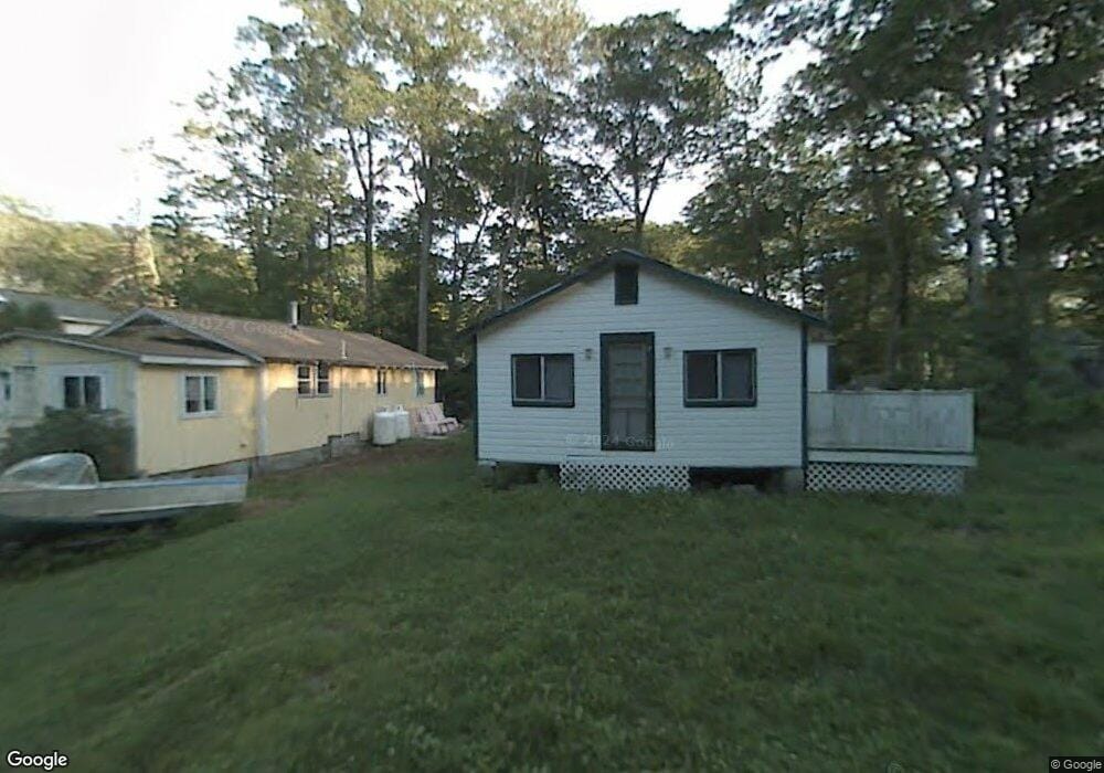
12 Kosta Ave Rutland, MA 01543
Estimated Value: $202,000 - $336,000
2
Beds
2
Baths
1,240
Sq Ft
$229/Sq Ft
Est. Value
About This Home
This home is located at 12 Kosta Ave, Rutland, MA 01543 and is currently estimated at $284,266, approximately $229 per square foot. 12 Kosta Ave is a home located in Worcester County with nearby schools including Wachusett Regional High School.
Ownership History
Date
Name
Owned For
Owner Type
Purchase Details
Closed on
Jun 1, 2021
Sold by
Kent Mark S and Kent Tara C
Bought by
Tiny Manor Llc
Current Estimated Value
Purchase Details
Closed on
Jul 11, 2019
Sold by
Besse Philip F
Bought by
Kent Mark S and Kent Tara C
Purchase Details
Closed on
Jul 2, 2014
Sold by
Est Daly Ruth E and Daly John A
Bought by
Besse Philip F and Swedberg Robert K
Purchase Details
Closed on
Jun 8, 2012
Sold by
Daly John A
Bought by
Daly John A and Daly Ellen J
Create a Home Valuation Report for This Property
The Home Valuation Report is an in-depth analysis detailing your home's value as well as a comparison with similar homes in the area
Home Values in the Area
Average Home Value in this Area
Purchase History
| Date | Buyer | Sale Price | Title Company |
|---|---|---|---|
| Tiny Manor Llc | $80,000 | None Available | |
| Kent Mark S | $9,999 | -- | |
| Besse Philip F | $5,000 | -- | |
| Daly John A | -- | -- |
Source: Public Records
Tax History Compared to Growth
Tax History
| Year | Tax Paid | Tax Assessment Tax Assessment Total Assessment is a certain percentage of the fair market value that is determined by local assessors to be the total taxable value of land and additions on the property. | Land | Improvement |
|---|---|---|---|---|
| 2025 | $2,224 | $156,200 | $73,000 | $83,200 |
| 2024 | $1,889 | $127,400 | $64,800 | $62,600 |
| 2023 | $1,624 | $118,400 | $61,100 | $57,300 |
| 2022 | $1,618 | $102,500 | $52,000 | $50,500 |
| 2021 | $1,571 | $94,100 | $51,400 | $42,700 |
| 2020 | $815 | $46,300 | $41,600 | $4,700 |
| 2019 | $723 | $40,400 | $35,400 | $5,000 |
| 2018 | $727 | $40,100 | $35,400 | $4,700 |
| 2017 | $735 | $40,100 | $35,400 | $4,700 |
| 2016 | $875 | $50,400 | $36,200 | $14,200 |
| 2015 | $1,476 | $83,600 | $36,200 | $47,400 |
| 2014 | $1,430 | $83,600 | $36,200 | $47,400 |
Source: Public Records
Map
Nearby Homes
- 2 Kosta Ave
- 7 Victoria Ave
- 4 Wilson Way
- 14 Welch Ave Unit A
- 7 Emerald Rd
- 289 Richards Ave
- 236 Turkey Hill Rd
- LOT 8 Pierre Cir
- 11 Brigham Rd
- 189 Maple Ave
- 176 Maple Ave Unit 1-38
- 176 Maple Ave Unit 3-25
- 176 Maple Ave Unit 2-26
- 43 Irish Ln
- 37 Irish Ln
- 39 Irish Ln
- 217 Grove St
- 7 Prescott St
- 132 Fidelity Dr Unit 61
- 12 Fidelity Dr Unit 6