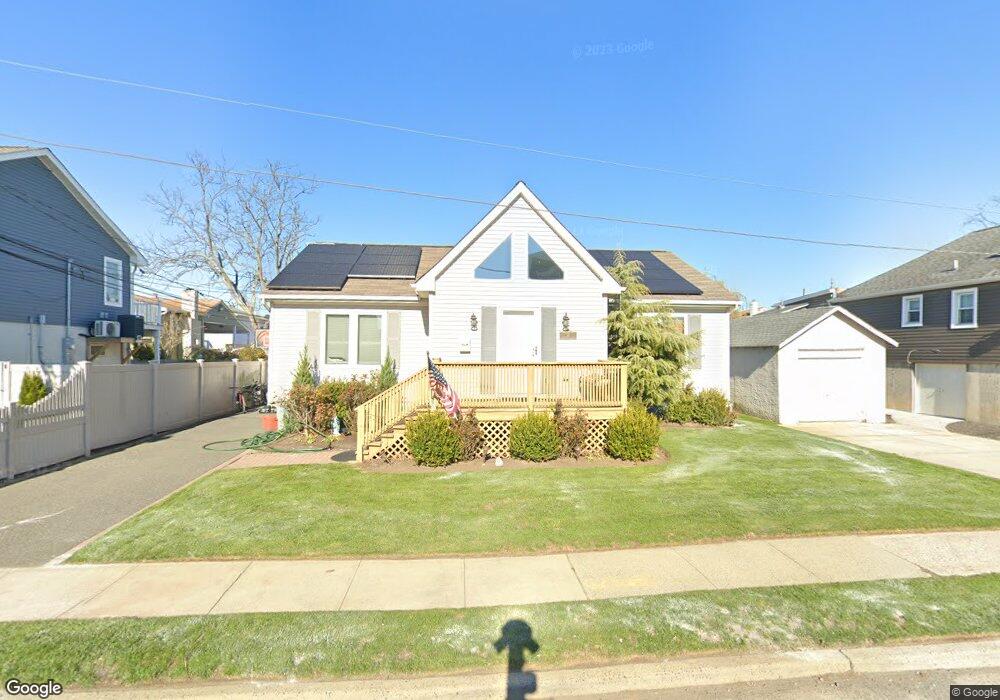
12 Lancaster Rd Island Park, NY 11558
Estimated Value: $571,000 - $632,335
3
Beds
2
Baths
1,300
Sq Ft
$463/Sq Ft
Est. Value
About This Home
This home is located at 12 Lancaster Rd, Island Park, NY 11558 and is currently estimated at $601,668, approximately $462 per square foot. 12 Lancaster Rd is a home located in Nassau County with nearby schools including Francis X Hegarty Elementary School, Lincoln Orens Middle School, and Long Beach Catholic Regional School.
Ownership History
Date
Name
Owned For
Owner Type
Purchase Details
Closed on
Nov 6, 2019
Sold by
Messenger Glenn and Wagner Robert
Bought by
Hamilton John
Current Estimated Value
Home Financials for this Owner
Home Financials are based on the most recent Mortgage that was taken out on this home.
Original Mortgage
$352,000
Outstanding Balance
$309,049
Interest Rate
3.5%
Mortgage Type
New Conventional
Estimated Equity
$292,619
Purchase Details
Closed on
May 12, 2009
Sold by
Depalma Joseph
Bought by
Messenger Glenn
Create a Home Valuation Report for This Property
The Home Valuation Report is an in-depth analysis detailing your home's value as well as a comparison with similar homes in the area
Home Values in the Area
Average Home Value in this Area
Purchase History
| Date | Buyer | Sale Price | Title Company |
|---|---|---|---|
| Hamilton John | $440,000 | Security Title | |
| Messenger Glenn | $383,250 | -- |
Source: Public Records
Mortgage History
| Date | Status | Borrower | Loan Amount |
|---|---|---|---|
| Open | Hamilton John | $352,000 |
Source: Public Records
Tax History Compared to Growth
Tax History
| Year | Tax Paid | Tax Assessment Tax Assessment Total Assessment is a certain percentage of the fair market value that is determined by local assessors to be the total taxable value of land and additions on the property. | Land | Improvement |
|---|---|---|---|---|
| 2025 | $8,373 | $394 | $149 | $245 |
| 2024 | $1,644 | $398 | $152 | $246 |
| 2023 | $7,851 | $414 | $159 | $255 |
| 2022 | $7,851 | $419 | $160 | $259 |
| 2021 | $10,656 | $421 | $161 | $260 |
| 2020 | $8,393 | $833 | $539 | $294 |
| 2019 | $2,077 | $833 | $539 | $294 |
| 2018 | $5,973 | $833 | $0 | $0 |
| 2017 | $5,738 | $833 | $539 | $294 |
| 2016 | $7,640 | $833 | $539 | $294 |
| 2015 | $1,866 | $833 | $539 | $294 |
| 2014 | $1,866 | $833 | $539 | $294 |
| 2013 | $1,736 | $833 | $539 | $294 |
Source: Public Records
Map
Nearby Homes
- 68 Lincoln Ave
- 31 Kent Rd Unit New Construction!!
- 38 Kent Rd
- 5 Sheridan Place
- 134 Mckinley Ave
- 185 Quebec Rd
- 7 Sherborne Place
- 227 Mckinley Ave
- 19 Parma Rd
- 100- 18 Baker Ct
- 100 Baker Ct Unit 63
- 100 Baker Ct Unit 50
- 100 Baker Ct Unit 15
- 100 Baker Ct Unit 128
- 100 Baker Ct Unit 36
- 12 Pershing Place
- 208 Island Pkwy W
- 208 Block Ln
- 9 Hamilton Ave
- 709 Monroe Blvd
- 14 Lancaster Rd
- 6 Lancaster Rd
- 43 Suffolk Rd
- 43 Suffolk Rd
- 19 Brighton Rd
- 2 Lancaster Rd
- 5 Lancaster Rd
- 23 Brighton Rd
- 47 Suffolk Rd
- 11 Lancaster Rd
- 18 Lancaster Rd
- 15 Brighton Rd
- 9 Lancaster Rd
- 0 Brighton Unit 2814398
- 13 Lancaster Rd
- 1 Lancaster Rd
- 1 Lancaster Rd Unit Lower
- 27 Brighton Rd
- 27 Brighton Rd
- 27 Brighton Rd