
Seller's Agent in 2025
Tiffany Semprini
The Aland Realty Group
(603) 770-4531
17 in this area
123 Total Sales

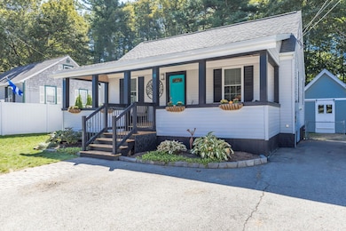
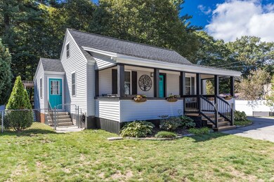
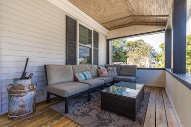
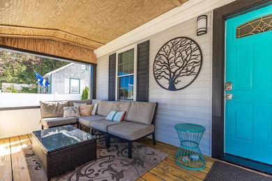
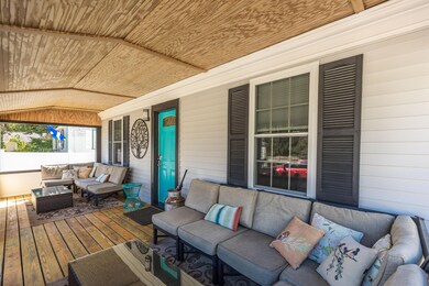
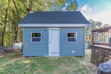
Welcome to this adorable Cape where charm and convenience of lifestyle meet. This gem boasts a covered front porch, perfect for enjoying your mornings and relaxing in the evenings. The private back yard offers ample outdoor space with a sizable deck, patio and fire pit. An ideal spot for hosting outdoor gatherings. A bonus to this property is the addition of a newly constructed outbuilding with electricity. Nestled in an established neighborhood, just a mile from the scenic Foreside and a short distance to Downtown Portsmouth, Beaches, Major routes and Recreation. On the floor you wil find an updated kitchen with ample living and dining space, two bedrooms and full bath. The second floor leads to two more bedrooms and or flex space. Natural light warms all of these spaces, creating an inviting and welcoming home. Some of the many updates include: New windows, Doors, Water heater and Newer roof. Grab a coffee at one of Kittery's eateries and stop by this move-in ready home!
Last Agent to Sell the Property
The Aland Realty Group License #070220 Listed on: 09/23/2025
| Date | Type | Sale Price | Title Company |
|---|---|---|---|
| Warranty Deed | $530,000 | -- | |
| Quit Claim Deed | -- | -- | |
| Interfamily Deed Transfer | -- | -- |
| Date | Status | Loan Amount | Loan Type |
|---|---|---|---|
| Open | $273,000 | Purchase Money Mortgage | |
| Previous Owner | $167,500 | New Conventional |
| Date | Event | Price | List to Sale | Price per Sq Ft |
|---|---|---|---|---|
| 10/30/2025 10/30/25 | Sold | $530,000 | +2.1% | $451 / Sq Ft |
| 09/23/2025 09/23/25 | For Sale | $519,000 | -- | $442 / Sq Ft |
| Year | Tax Paid | Tax Assessment Tax Assessment Total Assessment is a certain percentage of the fair market value that is determined by local assessors to be the total taxable value of land and additions on the property. | Land | Improvement |
|---|---|---|---|---|
| 2024 | $4,009 | $282,300 | $130,900 | $151,400 |
| 2023 | $3,842 | $282,300 | $130,900 | $151,400 |
| 2022 | $3,799 | $281,800 | $130,900 | $150,900 |
| 2021 | $3,634 | $279,500 | $130,900 | $148,600 |
| 2020 | $3,606 | $279,500 | $130,900 | $148,600 |
| 2019 | $3,045 | $175,000 | $57,000 | $118,000 |
| 2018 | $2,940 | $175,000 | $57,000 | $118,000 |
| 2017 | $2,888 | $175,000 | $57,000 | $118,000 |
| 2016 | $2,809 | $175,000 | $57,000 | $118,000 |
| 2015 | $2,742 | $175,000 | $57,000 | $118,000 |
| 2014 | $2,716 | $175,000 | $57,000 | $118,000 |
| 2013 | $2,664 | $175,000 | $57,000 | $118,000 |
Seller's Agent in 2025
Tiffany Semprini
The Aland Realty Group
(603) 770-4531
17 in this area
123 Total Sales
Buyer's Agent in 2025
Jon McCormack
Duston Leddy Real Estate
(603) 661-7830
4 in this area
99 Total Sales
Source: PrimeMLS
MLS Number: 5062636
APN: KITT-000014-000000-000096
Disclaimer: Certain information contained herein is derived from information provided by parties other than Homes.com. All information provided is deemed reliable, but is not guaranteed to be accurate and should be independently verified.
![]() Copyright 2025 PrimeMLS, Inc. All rights reserved. This information is deemed reliable, but not guaranteed. The data relating to real estate displayed on this display comes in part from the IDX Program of PrimeMLS. The information being provided is for consumers’ personal, non-commercial use and may not be used for any purpose other than to identify prospective properties consumers may be interested in purchasing.
Copyright 2025 PrimeMLS, Inc. All rights reserved. This information is deemed reliable, but not guaranteed. The data relating to real estate displayed on this display comes in part from the IDX Program of PrimeMLS. The information being provided is for consumers’ personal, non-commercial use and may not be used for any purpose other than to identify prospective properties consumers may be interested in purchasing.