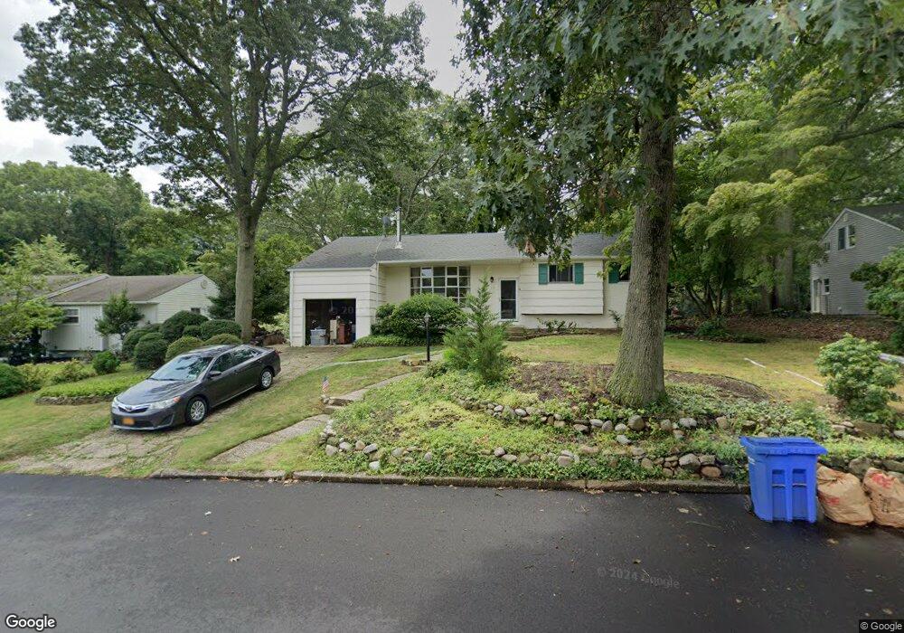
12 Laurel Dr Port Jefferson, NY 11777
Estimated Value: $571,658 - $591,000
--
Bed
--
Bath
--
Sq Ft
0.25
Acres
About This Home
This home is located at 12 Laurel Dr, Port Jefferson, NY 11777 and is currently estimated at $581,329. 12 Laurel Dr is a home located in Suffolk County with nearby schools including Edna Louise Spear Elementary, Port Jefferson Middle School, and Earl L Vandermeulen High School.
Ownership History
Date
Name
Owned For
Owner Type
Purchase Details
Closed on
Dec 21, 1999
Sold by
Ceo Richard P and Ceo Mary V
Bought by
Ceo Richard F and Ceo Mary
Current Estimated Value
Home Financials for this Owner
Home Financials are based on the most recent Mortgage that was taken out on this home.
Original Mortgage
$68,987
Interest Rate
7.98%
Mortgage Type
FHA
Purchase Details
Closed on
Jan 12, 1995
Sold by
Ceo Richard and Ceo Michael P
Bought by
Ceo Richard and Ceo Mary
Create a Home Valuation Report for This Property
The Home Valuation Report is an in-depth analysis detailing your home's value as well as a comparison with similar homes in the area
Home Values in the Area
Average Home Value in this Area
Purchase History
| Date | Buyer | Sale Price | Title Company |
|---|---|---|---|
| Ceo Richard F | -- | Servamerica National Title | |
| Ceo Richard | -- | -- |
Source: Public Records
Mortgage History
| Date | Status | Borrower | Loan Amount |
|---|---|---|---|
| Closed | Ceo Richard F | $68,987 |
Source: Public Records
Tax History Compared to Growth
Tax History
| Year | Tax Paid | Tax Assessment Tax Assessment Total Assessment is a certain percentage of the fair market value that is determined by local assessors to be the total taxable value of land and additions on the property. | Land | Improvement |
|---|---|---|---|---|
| 2024 | $8,544 | $2,800 | $300 | $2,500 |
| 2023 | $8,544 | $2,800 | $300 | $2,500 |
| 2022 | $6,421 | $2,800 | $300 | $2,500 |
| 2021 | $6,421 | $2,800 | $300 | $2,500 |
| 2020 | $7,718 | $2,800 | $300 | $2,500 |
| 2019 | $7,689 | $0 | $0 | $0 |
| 2018 | $6,256 | $2,800 | $300 | $2,500 |
| 2017 | $6,256 | $2,800 | $300 | $2,500 |
| 2016 | $6,249 | $2,800 | $300 | $2,500 |
| 2015 | -- | $2,800 | $300 | $2,500 |
| 2014 | -- | $2,800 | $300 | $2,500 |
Source: Public Records
Map
Nearby Homes
- 2 Puritan Path
- 101 Nadia Ct
- 49 Rockledge Path
- 330 E Broadway
- 98 Soundview Dr
- 39 Jefferson Landing Cir
- 28 Timberline Cir
- 416A.2 Oakwood Rd
- 319 Thompson St
- 18 Watersedge Way
- 0 Belle Terre Rd
- 5 Princess Tree Ct
- 416A Oakwood Rd
- 41 Landing Ln
- 3 Heidi Ln
- 38 Landing Ln
- 42 Sands Ln
- 6 Edgewood Ave
- 111 Campbell St
- 515 High St Unit 17