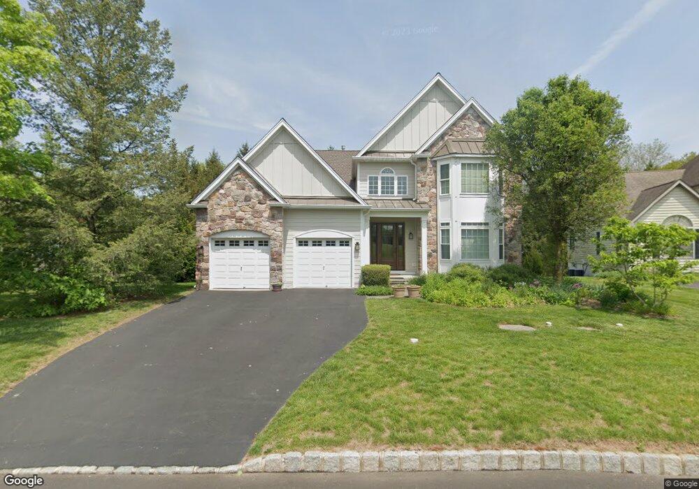
12 Lenape Dr New Hope, PA 18938
Estimated Value: $1,036,000 - $1,186,000
4
Beds
5
Baths
4,066
Sq Ft
$276/Sq Ft
Est. Value
About This Home
This home is located at 12 Lenape Dr, New Hope, PA 18938 and is currently estimated at $1,121,192, approximately $275 per square foot. 12 Lenape Dr is a home located in Bucks County with nearby schools including Sol Feinstone Elementary School, Newtown Middle School, and Council Rock High School North.
Ownership History
Date
Name
Owned For
Owner Type
Purchase Details
Closed on
Apr 28, 2000
Sold by
Westrum Orchards Ltd Partnership
Bought by
Skolas John A and Skolas Joan L
Current Estimated Value
Home Financials for this Owner
Home Financials are based on the most recent Mortgage that was taken out on this home.
Original Mortgage
$220,000
Interest Rate
7.87%
Create a Home Valuation Report for This Property
The Home Valuation Report is an in-depth analysis detailing your home's value as well as a comparison with similar homes in the area
Home Values in the Area
Average Home Value in this Area
Purchase History
| Date | Buyer | Sale Price | Title Company |
|---|---|---|---|
| Skolas John A | $393,632 | Lawyers Title Insurance Corp |
Source: Public Records
Mortgage History
| Date | Status | Borrower | Loan Amount |
|---|---|---|---|
| Previous Owner | Skolas John A | $220,000 |
Source: Public Records
Tax History Compared to Growth
Tax History
| Year | Tax Paid | Tax Assessment Tax Assessment Total Assessment is a certain percentage of the fair market value that is determined by local assessors to be the total taxable value of land and additions on the property. | Land | Improvement |
|---|---|---|---|---|
| 2025 | $11,262 | $65,840 | $9,320 | $56,520 |
| 2024 | $11,262 | $65,840 | $9,320 | $56,520 |
| 2023 | $10,954 | $65,840 | $9,320 | $56,520 |
| 2022 | $10,897 | $65,840 | $9,320 | $56,520 |
| 2021 | $10,750 | $65,840 | $9,320 | $56,520 |
| 2020 | $10,492 | $65,840 | $9,320 | $56,520 |
| 2019 | $10,249 | $65,840 | $9,320 | $56,520 |
| 2018 | $10,058 | $65,840 | $9,320 | $56,520 |
| 2017 | $9,782 | $65,840 | $9,320 | $56,520 |
| 2016 | $9,930 | $65,840 | $9,320 | $56,520 |
| 2015 | -- | $65,840 | $9,320 | $56,520 |
| 2014 | -- | $65,840 | $9,320 | $56,520 |
Source: Public Records
Map
Nearby Homes
- 10 Lenape Dr
- 55 Woodside Ln
- 52 Woodside Ln
- 42 Woodside Ln
- 1324 River Rd
- 1556 River Rd
- 1556- 1556A River Rd
- 14 Old Cabin Rd
- 10 Bailey Dr
- 108 Beaumont Dr
- 29 Bailey Dr
- 87 Valley Rd
- 347 Lurgan Rd
- 65 Covered Bridge Rd
- 1476 River Rd
- 321 Lurgan Rd
- 420 Covered Bridge Rd
- 1 Canal Run W
- 32 Wrick Ave
- 71 Covered Bridge Rd