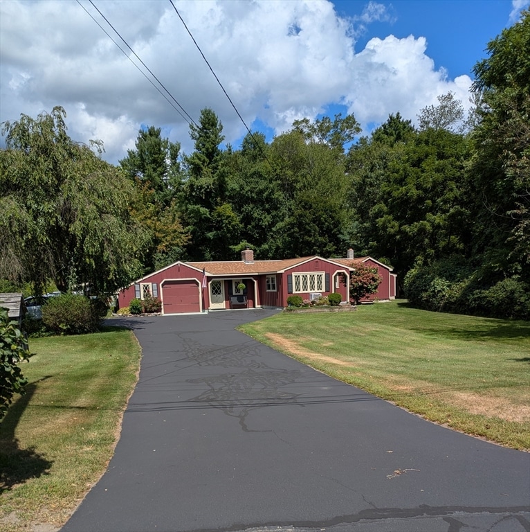
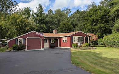


12 Lovering St Medway, MA 02053
Estimated payment $3,512/month
Highlights
- Medical Services
- Above Ground Pool
- Ranch Style House
- John D. McGovern Elementary School Rated A-
- Deck
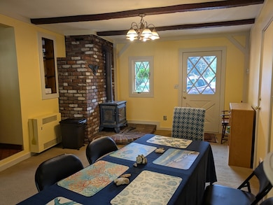
- 1 Fireplace
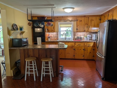
About This Home
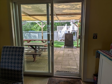
Charming, move-in ready, 3 bedroom/1 bath ranch in lovely residential neighborhood close to elementary schools and walking trails, on a private .56 acre lot. Features long, turn-around driveway with convenient parking. Home has attached 1 1/2 car garage with storage closet. Home includes all major appliances, brick fireplace with stone mantle and hearth, soapstone wood stove, gas cooking and dryer, tankless water heater, and 2 (two) 330 gallon oil tanks in separate furnace room. Property includes gambrel roofed storage shed, 24' round above-ground pool with new filtration system, gazebo with air chairs, and patio with trellis holding removable shade cover. Home is recently repainted inside and out, and roof replaced within past 8 years.
Home Details
Home Type
- Single Family
Est. Annual Taxes
- $6,190
Year Built
- Built in 1940
Lot Details
- 0.56 Acre Lot
- Level Lot
- Cleared Lot
- Property is zoned ARII
Parking
- 1 Car Garage
- Driveway
- Open Parking
Home Design
- Manufactured Home on a slab
- Ranch Style House
- Block Foundation
- Frame Construction
- Blown Fiberglass Insulation
- Blown-In Insulation
- Batts Insulation
- Shingle Roof
Interior Spaces
- 1,159 Sq Ft Home
- Sheet Rock Walls or Ceilings
- 1 Fireplace
- Storm Windows
Kitchen
- Oven
- Range with Range Hood
- Microwave
- Freezer
- Plumbed For Ice Maker
- Disposal
Flooring
- Carpet
- Vinyl
Bedrooms and Bathrooms
- 3 Bedrooms
- 1 Full Bathroom
Laundry
- ENERGY STAR Qualified Dryer
- ENERGY STAR Qualified Washer
Outdoor Features
- Above Ground Pool
- Deck
- Patio
- Gazebo
- Outdoor Storage
Location
- Property is near schools
Utilities
- 3+ Cooling Systems Mounted To A Wall/Window
- Cooling System Mounted In Outer Wall Opening
- Window Unit Cooling System
- 1 Cooling Zone
- 1 Heating Zone
- Heating System Uses Oil
- Baseboard Heating
- 110 Volts
- 100 Amp Service
- Tankless Water Heater
Listing and Financial Details
- Assessor Parcel Number M:31 B:012,3165951
Community Details
Overview
- No Home Owners Association
- Holliston/Lovering Subdivision
Amenities
- Medical Services
- Shops
Recreation
- Community Pool
- Park
- Jogging Path
Map
Home Values in the Area
Average Home Value in this Area
Tax History
| Year | Tax Paid | Tax Assessment Tax Assessment Total Assessment is a certain percentage of the fair market value that is determined by local assessors to be the total taxable value of land and additions on the property. | Land | Improvement |
|---|---|---|---|---|
| 2025 | $6,190 | $434,400 | $270,600 | $163,800 |
| 2024 | $6,255 | $434,400 | $270,600 | $163,800 |
| 2023 | $5,904 | $370,400 | $233,200 | $137,200 |
| 2022 | $5,262 | $310,800 | $208,200 | $102,600 |
| 2021 | $5,577 | $319,400 | $187,400 | $132,000 |
| 2020 | $5,224 | $298,500 | $166,500 | $132,000 |
| 2019 | $5,021 | $295,900 | $166,500 | $129,400 |
| 2018 | $5,030 | $284,800 | $145,700 | $139,100 |
| 2017 | $4,390 | $245,000 | $135,300 | $109,700 |
| 2016 | $4,372 | $241,400 | $130,300 | $111,100 |
| 2015 | $4,266 | $233,900 | $122,800 | $111,100 |
| 2014 | $4,226 | $224,300 | $129,100 | $95,200 |
Property History
| Date | Event | Price | List to Sale | Price per Sq Ft |
|---|---|---|---|---|
| 11/19/2025 11/19/25 | Pending | -- | -- | -- |
| 10/28/2025 10/28/25 | Price Changed | $569,000 | -3.4% | $491 / Sq Ft |
| 08/29/2025 08/29/25 | Price Changed | $589,000 | 0.0% | $508 / Sq Ft |
| 08/29/2025 08/29/25 | For Sale | $589,000 | -4.1% | $508 / Sq Ft |
| 08/26/2025 08/26/25 | Off Market | $614,000 | -- | -- |
| 08/15/2025 08/15/25 | For Sale | $614,000 | -- | $530 / Sq Ft |
Purchase History
| Date | Type | Sale Price | Title Company |
|---|---|---|---|
| Quit Claim Deed | -- | -- | |
| Deed | -- | -- | |
| Deed | $250,000 | -- |
Mortgage History
| Date | Status | Loan Amount | Loan Type |
|---|---|---|---|
| Previous Owner | $246,137 | Purchase Money Mortgage |
Source: MLS Property Information Network (MLS PIN)
MLS Number: 73418751
APN: MEDW-000031-000000-000012
Disclaimer: Certain information contained herein is derived from information provided by parties other than Homes.com. All information provided is deemed reliable, but is not guaranteed to be accurate and should be independently verified.
![]() The property listing data and information, or the Images, set forth herein were provided to MLS Property Information Network, Inc. from third party sources, including sellers, lessors and public records, and were compiled by MLS Property Information Network, Inc. The property listing data and information, and the Images, are for the personal, non-commercial use of consumers having a good faith interest in purchasing or leasing listed properties of the type displayed to them and may not be used for any purpose other than to identify prospective properties which such consumers may have a good faith interest in purchasing or leasing. MLS Property Information Network, Inc. and its subscribers disclaim any and all representations and warranties as to the accuracy of the property listing data and information, or as to the accuracy of any of the Images, set forth herein.
The property listing data and information, or the Images, set forth herein were provided to MLS Property Information Network, Inc. from third party sources, including sellers, lessors and public records, and were compiled by MLS Property Information Network, Inc. The property listing data and information, and the Images, are for the personal, non-commercial use of consumers having a good faith interest in purchasing or leasing listed properties of the type displayed to them and may not be used for any purpose other than to identify prospective properties which such consumers may have a good faith interest in purchasing or leasing. MLS Property Information Network, Inc. and its subscribers disclaim any and all representations and warranties as to the accuracy of the property listing data and information, or as to the accuracy of any of the Images, set forth herein.
- 106 Holliston St
- 36 Lovering St
- 3 Meryl St
- 22 Sunset Dr
- 14 Heritage Dr
- 50 Main St
- 1 Walnut Ln
- 19 Sycamore Way Unit L40
- 30 Broken Tree Rd
- 176 Main St Unit 3
- 280 Village St Unit D2
- 28 Wellington St
- 116 Winthrop St
- 4 Shaw St
- 20 Broad St Unit 6
- 20 Broad St Unit A
- 20 Broad St Unit 4
- 9 Sanford St
- 0 Hill St
- 12 Longmeadow Ln
