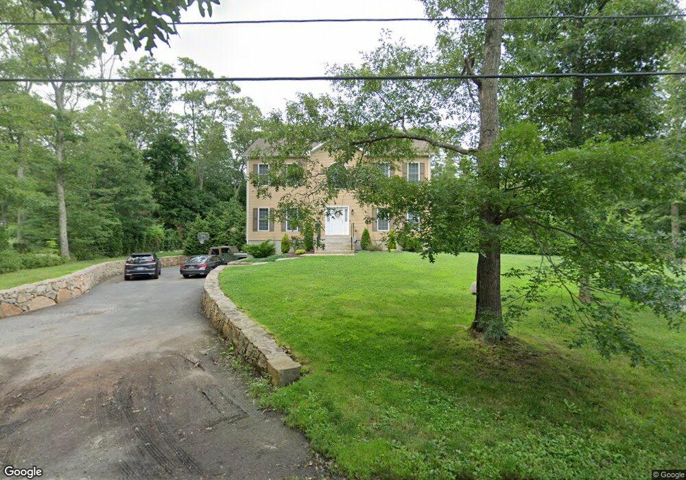
12 Maple Dr Tiverton, RI 02878
South Tiverton NeighborhoodEstimated Value: $701,000 - $742,000
3
Beds
3
Baths
2,314
Sq Ft
$312/Sq Ft
Est. Value
About This Home
This home is located at 12 Maple Dr, Tiverton, RI 02878 and is currently estimated at $721,002, approximately $311 per square foot. 12 Maple Dr is a home with nearby schools including Tiverton High School.
Ownership History
Date
Name
Owned For
Owner Type
Purchase Details
Closed on
Jul 31, 2020
Sold by
Carvalho Brian T and Valencia Carolyn
Bought by
Carvalho Brian T and Valencia Carolyn
Current Estimated Value
Purchase Details
Closed on
Jun 30, 2000
Sold by
Woodlot 12 Subdivision
Bought by
Jps Realty Mtg Co
Home Financials for this Owner
Home Financials are based on the most recent Mortgage that was taken out on this home.
Original Mortgage
$50,000
Interest Rate
8.59%
Mortgage Type
Purchase Money Mortgage
Create a Home Valuation Report for This Property
The Home Valuation Report is an in-depth analysis detailing your home's value as well as a comparison with similar homes in the area
Home Values in the Area
Average Home Value in this Area
Purchase History
| Date | Buyer | Sale Price | Title Company |
|---|---|---|---|
| Carvalho Brian T | -- | None Available | |
| Jps Realty Mtg Co | $55,000 | -- |
Source: Public Records
Mortgage History
| Date | Status | Borrower | Loan Amount |
|---|---|---|---|
| Previous Owner | Jps Realty Mtg Co | $31,300 | |
| Previous Owner | Jps Realty Mtg Co | $292,000 | |
| Previous Owner | Jps Realty Mtg Co | $50,000 |
Source: Public Records
Tax History
| Year | Tax Paid | Tax Assessment Tax Assessment Total Assessment is a certain percentage of the fair market value that is determined by local assessors to be the total taxable value of land and additions on the property. | Land | Improvement |
|---|---|---|---|---|
| 2025 | $6,692 | $605,600 | $120,800 | $484,800 |
| 2024 | $6,692 | $605,600 | $120,800 | $484,800 |
| 2023 | $6,276 | $421,200 | $102,000 | $319,200 |
| 2022 | $6,162 | $421,200 | $102,000 | $319,200 |
| 2021 | $6,011 | $421,200 | $102,000 | $319,200 |
| 2020 | $5,859 | $361,900 | $91,600 | $270,300 |
| 2019 | $5,714 | $361,900 | $91,600 | $270,300 |
| 2018 | $5,932 | $361,900 | $91,600 | $270,300 |
| 2017 | $6,287 | $330,000 | $91,600 | $238,400 |
| 2016 | $6,316 | $330,000 | $91,600 | $238,400 |
| 2015 | $6,316 | $330,000 | $91,600 | $238,400 |
| 2014 | $6,296 | $326,200 | $91,600 | $234,600 |
Source: Public Records
Map
Nearby Homes
- 1070 Crandall Rd Unit 4
- 394 Lake Rd
- 374 Crandall Rd
- 24 Cala Ave
- 10 Elise Michelle Way
- 3118 Main Rd
- 0 Seapowet Ave
- 50 Tower Hill Rd
- 301 Bulgarmarsh Rd
- 3622 Main Rd
- 214 Sawdy Dr
- 8 Campion Ave
- 47 Robert St
- 32 Arrowhead Dr
- 179 Robert St
- 89 North Ct
- 1282 East Rd
- 0 Riverscape Ln Unit 73452278
- 1023 Old Stafford Rd
- 68 Riverscape Ln
Your Personal Tour Guide
Ask me questions while you tour the home.