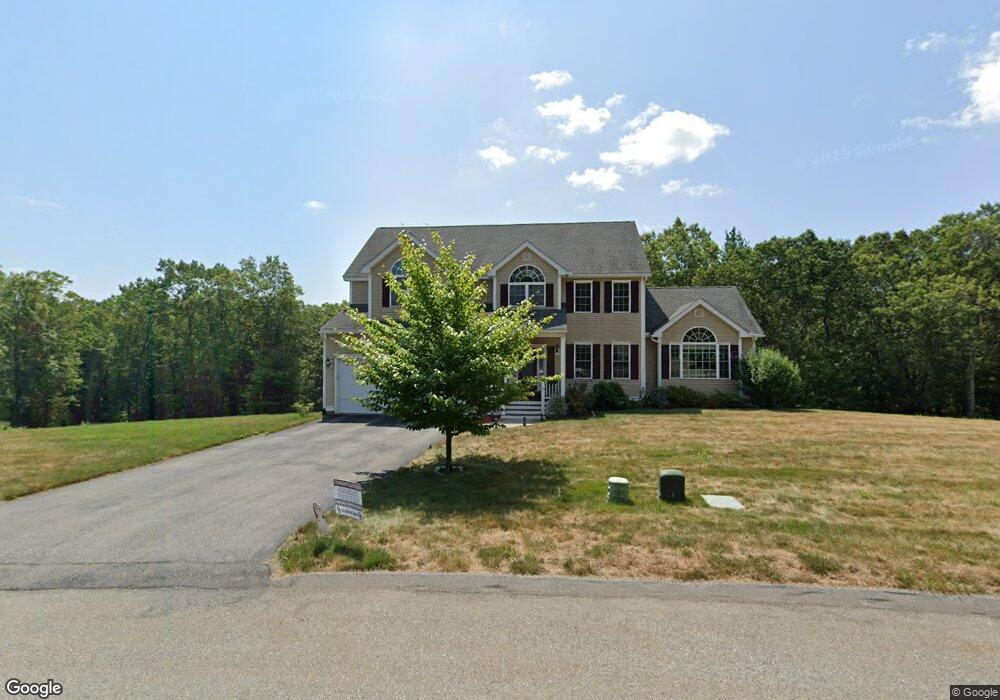
12 Mockingbird Hill Rd Groton, MA 01450
Estimated Value: $1,074,000 - $1,286,000
4
Beds
5
Baths
2,825
Sq Ft
$416/Sq Ft
Est. Value
About This Home
This home is located at 12 Mockingbird Hill Rd, Groton, MA 01450 and is currently estimated at $1,175,075, approximately $415 per square foot. 12 Mockingbird Hill Rd is a home with nearby schools including Groton Dunstable Regional High School, Groton Community School, and Seven Hills At Groton.
Ownership History
Date
Name
Owned For
Owner Type
Purchase Details
Closed on
Apr 17, 2018
Sold by
Moulton Construction C
Bought by
Sreepathi Ananth and Sreepathi Chaitanya
Current Estimated Value
Home Financials for this Owner
Home Financials are based on the most recent Mortgage that was taken out on this home.
Original Mortgage
$645,000
Outstanding Balance
$538,460
Interest Rate
3.25%
Mortgage Type
Unknown
Estimated Equity
$636,615
Create a Home Valuation Report for This Property
The Home Valuation Report is an in-depth analysis detailing your home's value as well as a comparison with similar homes in the area
Home Values in the Area
Average Home Value in this Area
Purchase History
| Date | Buyer | Sale Price | Title Company |
|---|---|---|---|
| Sreepathi Ananth | $739,000 | -- | |
| Sreepathi Ananth | $739,000 | -- |
Source: Public Records
Mortgage History
| Date | Status | Borrower | Loan Amount |
|---|---|---|---|
| Open | Sreepathi Ananth | $645,000 | |
| Closed | Sreepathi Ananth | $645,000 |
Source: Public Records
Tax History Compared to Growth
Tax History
| Year | Tax Paid | Tax Assessment Tax Assessment Total Assessment is a certain percentage of the fair market value that is determined by local assessors to be the total taxable value of land and additions on the property. | Land | Improvement |
|---|---|---|---|---|
| 2025 | $15,836 | $1,038,400 | $301,300 | $737,100 |
| 2024 | $15,733 | $1,042,600 | $301,300 | $741,300 |
| 2023 | $14,872 | $950,900 | $301,300 | $649,600 |
| 2022 | $12,769 | $742,800 | $239,700 | $503,100 |
| 2021 | $12,744 | $724,100 | $217,400 | $506,700 |
| 2020 | $13,289 | $764,600 | $235,500 | $529,100 |
| 2019 | $12,840 | $709,000 | $253,600 | $455,400 |
| 2018 | $4,453 | $238,500 | $110,600 | $127,900 |
| 2017 | $2,020 | $110,600 | $110,600 | $0 |
| 2016 | $1,797 | $95,700 | $95,700 | $0 |
| 2015 | $1,748 | $95,700 | $95,700 | $0 |
Source: Public Records
Map
Nearby Homes
- 95 Hummingbird Ln Unit 22
- 35 Oxbow Ln
- 8 Mulberry Cir
- Lot 6 Noble Path
- Lot 7 Noble Path
- 222 Forge Village Rd
- 6 Little Hollow Ln
- 12 Oriole Dr
- 4 Spectacle Pond Rd
- 12 Brookfield Dr Unit A
- 49 Boat House Rd
- 239 Ayer Rd Unit 16
- 36 Whitetail Way
- 227 Boston Rd
- 72 Dale Ln
- 65 Skyfields Dr
- PL 639 Indian Hill Rd
- 0 Arrow Trail
- 75 Sandy Pond Rd Unit 44
- 75 Sandy Pond Rd Unit 7
- Lot 25 Mockingbird Hill Rd
- lot 22 Mockingbird Hill Rd
- Lot 24 Mockingbird Hill
- 14 Mockingbird Hill Rd
- 8 Mockingbird Hill Rd
- 7 Mockingbird Hill Rd
- 16 Mockingbird Hill Rd
- 31 Mockingbird Hill Rd
- 9 Mockingbird Hill Rd
- 6 Mockingbird Hill Rd
- 26 Mockingbird Hill Rd
- 30 Mockingbird Hill Rd
- 18 Mockingbird Hill Rd
- 5 Mockingbird Hill Rd
- 144 Robin Hill Rd
- 4 Mockingbird Hill Rd
- 108 Robin Hill Rd
- 140 Robin Hill Rd
- 150 Mockingbird Hill Rd
- 3 Mockingbird Hill Rd