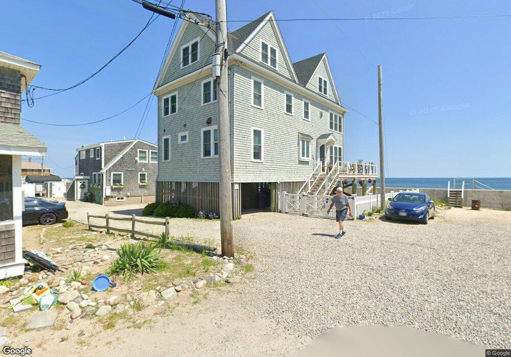
12 Monitor Rd Marshfield, MA 02050
Ocean Bluff-Brant Rock NeighborhoodEstimated Value: $2,179,000 - $2,873,000
3
Beds
2
Baths
1,500
Sq Ft
$1,682/Sq Ft
Est. Value
About This Home
This home is located at 12 Monitor Rd, Marshfield, MA 02050 and is currently estimated at $2,522,560, approximately $1,681 per square foot. 12 Monitor Rd is a home located in Plymouth County with nearby schools including Daniel Webster, Furnace Brook Middle School, and Marshfield High School.
Ownership History
Date
Name
Owned For
Owner Type
Purchase Details
Closed on
Jun 6, 2022
Sold by
Cox William and Cox Ann
Bought by
Suchoff Andrew and Suchoff Sandra
Current Estimated Value
Home Financials for this Owner
Home Financials are based on the most recent Mortgage that was taken out on this home.
Original Mortgage
$1,600,000
Outstanding Balance
$1,490,503
Interest Rate
3.5%
Mortgage Type
Purchase Money Mortgage
Estimated Equity
$1,032,057
Purchase Details
Closed on
Sep 27, 2021
Sold by
Maher Stephen M and Maher Sheryl H
Bought by
Cox William and Cox Ann
Purchase Details
Closed on
Jun 24, 2005
Sold by
Mcclellan Jane H
Bought by
Maher Stephen M and Khoury Sheryl H
Purchase Details
Closed on
Nov 25, 2002
Sold by
Masiello Helen C
Bought by
Mcclellan Jane H
Home Financials for this Owner
Home Financials are based on the most recent Mortgage that was taken out on this home.
Original Mortgage
$672,000
Interest Rate
6.07%
Mortgage Type
Purchase Money Mortgage
Create a Home Valuation Report for This Property
The Home Valuation Report is an in-depth analysis detailing your home's value as well as a comparison with similar homes in the area
Home Values in the Area
Average Home Value in this Area
Purchase History
| Date | Buyer | Sale Price | Title Company |
|---|---|---|---|
| Suchoff Andrew | $2,400,000 | None Available | |
| Cox William | $1,900,000 | None Available | |
| Maher Stephen M | $825,000 | -- | |
| Maher Stephen M | $825,000 | -- | |
| Mcclellan Jane H | $590,000 | -- | |
| Mcclellan Jane H | $590,000 | -- |
Source: Public Records
Mortgage History
| Date | Status | Borrower | Loan Amount |
|---|---|---|---|
| Open | Suchoff Andrew | $1,600,000 | |
| Previous Owner | Mcclellan Jane H | $672,000 |
Source: Public Records
Tax History Compared to Growth
Tax History
| Year | Tax Paid | Tax Assessment Tax Assessment Total Assessment is a certain percentage of the fair market value that is determined by local assessors to be the total taxable value of land and additions on the property. | Land | Improvement |
|---|---|---|---|---|
| 2025 | $22,638 | $2,286,700 | $833,500 | $1,453,200 |
| 2024 | $21,564 | $2,075,500 | $754,100 | $1,321,400 |
| 2023 | $19,456 | $1,865,100 | $714,400 | $1,150,700 |
| 2022 | $19,456 | $1,502,400 | $545,700 | $956,700 |
| 2021 | $12,598 | $955,100 | $466,300 | $488,800 |
| 2020 | $12,168 | $912,800 | $436,600 | $476,200 |
| 2019 | $11,875 | $887,500 | $436,600 | $450,900 |
| 2018 | $11,752 | $879,000 | $436,600 | $442,400 |
| 2017 | $11,639 | $848,300 | $436,600 | $411,700 |
| 2016 | $11,423 | $823,000 | $436,600 | $386,400 |
| 2015 | $9,290 | $699,000 | $516,000 | $183,000 |
| 2014 | $8,603 | $647,300 | $476,300 | $171,000 |
Source: Public Records
Map
Nearby Homes
- 12 Monitor Rd
- 16R Monitor Rd
- 16 Monitor Rd
- 18 Monitor Rd
- 13 Monitor Rd
- 17 Monitor Rd
- 11 Constellation Rd
- 17 Constellation Rd
- 24 Monitor Rd
- 23 Constellation Rd
- 23 Constellation Rd Unit 1
- 12 Farragut Rd
- 21 Monitor Rd
- 21 Monitor Rd Unit R
- 10 Constellation Rd
- 18 Constellation Rd
- 22 Farragut Rd
- 30 Monitor Rd
- 24 Constellation Rd
- 24 Constellation Rd Unit 24