Estimated Value: $1,382,446 - $1,838,000
4
Beds
4
Baths
3,735
Sq Ft
$415/Sq Ft
Est. Value
About This Home
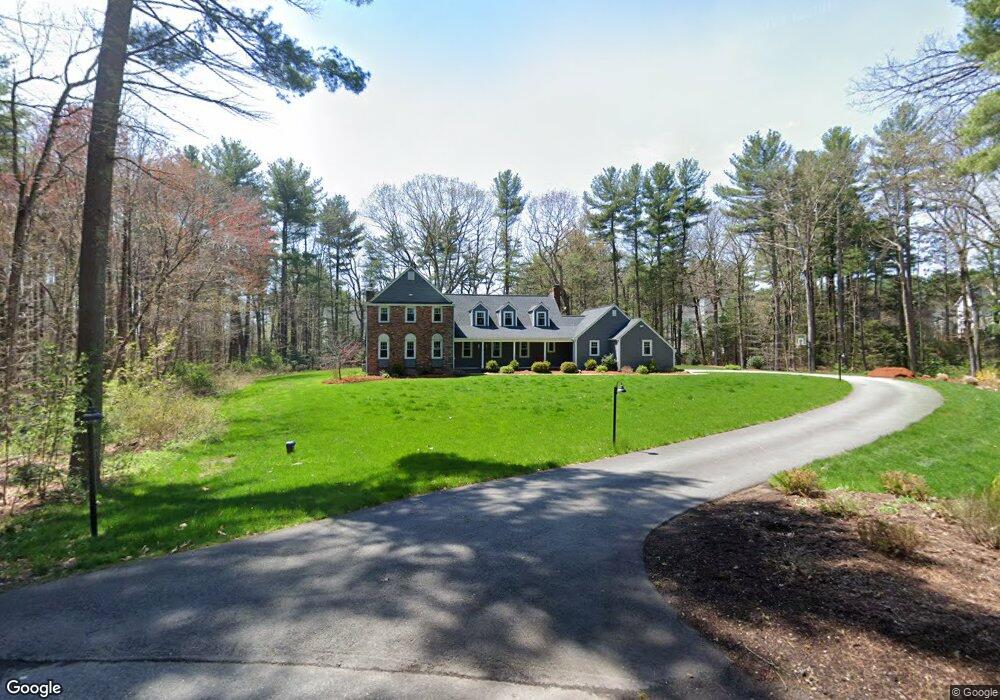
This home is located at 12 Partridge Pond Rd, Acton, MA 01720 and is currently estimated at $1,551,112, approximately $415 per square foot. 12 Partridge Pond Rd is a home located in Middlesex County with nearby schools including Acton-Boxborough Regional High School.
Ownership History
Date
Name
Owned For
Owner Type
Purchase Details
Closed on
Apr 15, 1994
Sold by
Brook David E and Brook Arlene D
Bought by
Kelly Mark J and Kelly Cynthia D
Current Estimated Value
Create a Home Valuation Report for This Property
The Home Valuation Report is an in-depth analysis detailing your home's value as well as a comparison with similar homes in the area
Home Values in the Area
Average Home Value in this Area
Purchase History
| Date | Buyer | Sale Price | Title Company |
|---|---|---|---|
| Kelly Mark J | $415,000 | -- |
Source: Public Records
Mortgage History
| Date | Status | Borrower | Loan Amount |
|---|---|---|---|
| Open | Kelly Mark J | $200,000 | |
| Open | Kelly Mark J | $300,000 |
Source: Public Records
Tax History
| Year | Tax Paid | Tax Assessment Tax Assessment Total Assessment is a certain percentage of the fair market value that is determined by local assessors to be the total taxable value of land and additions on the property. | Land | Improvement |
|---|---|---|---|---|
| 2025 | $24,451 | $1,425,700 | $443,100 | $982,600 |
| 2024 | $22,730 | $1,363,500 | $443,100 | $920,400 |
| 2023 | $20,884 | $1,189,300 | $403,100 | $786,200 |
| 2022 | $19,763 | $1,016,100 | $351,900 | $664,200 |
| 2021 | $19,684 | $973,000 | $326,300 | $646,700 |
| 2020 | $17,784 | $924,300 | $326,300 | $598,000 |
| 2019 | $17,220 | $889,000 | $326,300 | $562,700 |
| 2018 | $16,870 | $870,500 | $326,300 | $544,200 |
| 2017 | $16,426 | $861,800 | $326,300 | $535,500 |
| 2016 | $16,332 | $849,300 | $326,300 | $523,000 |
| 2015 | $15,693 | $823,800 | $326,300 | $497,500 |
| 2014 | $15,095 | $776,100 | $326,300 | $449,800 |
Source: Public Records
Map
Nearby Homes
- 3 Stacys Way
- 11 Partridge Pond Rd
- 7 Stacys Way
- 5 Stacys Way
- 10 Partridge Pond Rd
- 9 Partridge Pond Rd
- 1 Stacys Way
- 12 Stacys Way
- Lot 10 Stacy's Way
- 4 Stacy's Way Unit 4
- 7 Partridge Pond Rd
- 8 Partridge Pond Rd
- 8 Stacys Way
- 6 Stacys Way
- 10 Stacys Way
- 2 Stacys Way
- 9 Barker Rd
- 10 Huckleberry Ln
- 4 Stacys Way
- 7 Barker Rd
Your Personal Tour Guide
Ask me questions while you tour the home.