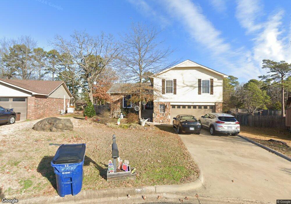
12 Pinehurst Way Maumelle, AR 72113
Estimated Value: $228,000 - $249,000
4
Beds
3
Baths
1,761
Sq Ft
$135/Sq Ft
Est. Value
About This Home
This home is located at 12 Pinehurst Way, Maumelle, AR 72113 and is currently estimated at $237,209, approximately $134 per square foot. 12 Pinehurst Way is a home located in Pulaski County with nearby schools including Pine Forest Elementary School, Maumelle Middle School, and Maumelle High School.
Ownership History
Date
Name
Owned For
Owner Type
Purchase Details
Closed on
Jul 20, 2005
Sold by
Gillam Michael and Gillam Arlene
Bought by
Mccormick Dennis and Mccormick Teresa
Current Estimated Value
Home Financials for this Owner
Home Financials are based on the most recent Mortgage that was taken out on this home.
Original Mortgage
$133,000
Outstanding Balance
$69,068
Interest Rate
5.58%
Mortgage Type
Fannie Mae Freddie Mac
Estimated Equity
$168,141
Create a Home Valuation Report for This Property
The Home Valuation Report is an in-depth analysis detailing your home's value as well as a comparison with similar homes in the area
Home Values in the Area
Average Home Value in this Area
Purchase History
| Date | Buyer | Sale Price | Title Company |
|---|---|---|---|
| Mccormick Dennis | $140,000 | Standard Abstract & Title Co |
Source: Public Records
Mortgage History
| Date | Status | Borrower | Loan Amount |
|---|---|---|---|
| Open | Mccormick Dennis | $133,000 |
Source: Public Records
Tax History Compared to Growth
Tax History
| Year | Tax Paid | Tax Assessment Tax Assessment Total Assessment is a certain percentage of the fair market value that is determined by local assessors to be the total taxable value of land and additions on the property. | Land | Improvement |
|---|---|---|---|---|
| 2025 | $2,050 | $36,418 | $4,000 | $32,418 |
| 2024 | $2,102 | $36,418 | $4,000 | $32,418 |
| 2023 | $2,102 | $36,418 | $4,000 | $32,418 |
| 2022 | $1,796 | $36,418 | $4,000 | $32,418 |
| 2021 | $1,911 | $30,380 | $5,600 | $24,780 |
| 2020 | $1,536 | $30,380 | $5,600 | $24,780 |
| 2019 | $1,536 | $30,380 | $5,600 | $24,780 |
| 2018 | $1,561 | $30,380 | $5,600 | $24,780 |
| 2017 | $1,561 | $30,380 | $5,600 | $24,780 |
| 2016 | $1,563 | $30,420 | $5,600 | $24,820 |
| 2015 | $1,897 | $30,161 | $5,600 | $24,561 |
| 2014 | $1,897 | $27,641 | $5,600 | $22,041 |
Source: Public Records
Map
Nearby Homes
- 2 Kingspark Dr
- 9 Oak Ridge Dr
- 43 Prince Dr
- 40 Prince Dr
- 31 Kingspark Dr
- 10 Willow Oak Loop
- 18 Willow Oak Loop
- 9 Smoking Oaks Dr
- 8 Millstone Cove
- 78 Garden Oaks Dr
- 11 Millstone Cove
- 2 Bishop Ct
- 16 Rockledge Place
- 101 Pine Forest Dr
- 58 Vantage Dr
- 200 Pine Forest Dr
- 37 Garden Oaks Dr
- Lot 8 Ellia's Cove
- Lot 12 Ellia's Cove
- Lot 11 Ellia's Cove
- 13 Pinehurst Way
- 11 Pinehurst Way
- 10 Pinehurst Way
- 1 Piney Cove Manor
- 9 Piney Cove Manor
- 49 Oak Forest Loop
- 4 Kingspark Dr
- 47 Oak Forest Loop
- 2 Pinehurst Way
- 3 Piney Cove Manor
- 45 Oak Forest Loop
- 51 Oak Forest Loop
- 1 Kingspark Dr
- 6 Kingspark Dr
- 0 Oak Forest Dr
- 19 Pinecrest Ln
- 0 Pinehurst Way
- 43 Oak Forest Loop
- 18 Pinecrest Ln
- 20 Pinecrest Ln