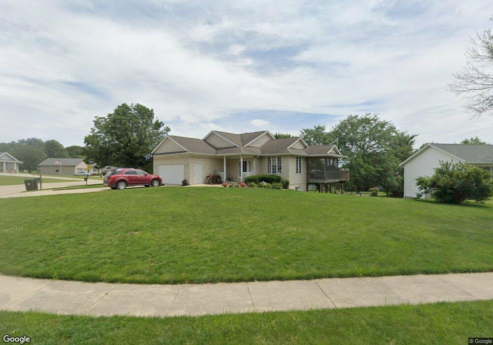
12 Red Maple Ct Central City, IA 52214
Estimated Value: $267,291 - $291,000
4
Beds
5
Baths
1,056
Sq Ft
$266/Sq Ft
Est. Value
About This Home
This home is located at 12 Red Maple Ct, Central City, IA 52214 and is currently estimated at $280,823, approximately $265 per square foot. 12 Red Maple Ct is a home located in Linn County with nearby schools including Central City Elementary School and Central City Junior High School.
Ownership History
Date
Name
Owned For
Owner Type
Purchase Details
Closed on
Oct 26, 2001
Sold by
Union Planters Bank National Assn
Bought by
Whitson Scott A and Whitson Staci L
Current Estimated Value
Home Financials for this Owner
Home Financials are based on the most recent Mortgage that was taken out on this home.
Original Mortgage
$107,200
Interest Rate
7.07%
Mortgage Type
Purchase Money Mortgage
Purchase Details
Closed on
Oct 20, 1998
Sold by
Village Green Ltd
Bought by
Scofield Larry J and Scofield Molly J
Purchase Details
Closed on
Aug 19, 1998
Sold by
Village Green Ltd
Bought by
Scofield Larry J and Scofield Molly J
Home Financials for this Owner
Home Financials are based on the most recent Mortgage that was taken out on this home.
Original Mortgage
$155,550
Interest Rate
7.12%
Mortgage Type
Purchase Money Mortgage
Create a Home Valuation Report for This Property
The Home Valuation Report is an in-depth analysis detailing your home's value as well as a comparison with similar homes in the area
Purchase History
We collect this data history from publicly available records. To have your information removed, we recommend requesting removal directly through your county’s website.
| Date | Buyer | Sale Price | Title Company |
|---|---|---|---|
| Whitson Scott A | $133,500 | -- | |
| Scofield Larry J | -- | -- | |
| Scofield Larry J | $144,000 | -- |
Source: Public Records
Mortgage History
We collect this data history from publicly available records. To have your information removed, we recommend requesting removal directly through your county’s website.
| Date | Status | Borrower | Loan Amount |
|---|---|---|---|
| Previous Owner | Whitson Scott A | $107,200 | |
| Previous Owner | Scofield Larry J | $155,550 |
Source: Public Records
Tax History
| Year | Tax Paid | Tax Assessment Tax Assessment Total Assessment is a certain percentage of the fair market value that is determined by local assessors to be the total taxable value of land and additions on the property. | Land | Improvement |
|---|---|---|---|---|
| 2025 | $3,614 | $257,100 | $31,900 | $225,200 |
| 2024 | $3,476 | $246,400 | $31,900 | $214,500 |
| 2023 | $3,476 | $246,400 | $31,900 | $214,500 |
| 2022 | $3,528 | $192,400 | $31,900 | $160,500 |
| 2021 | $3,270 | $192,400 | $31,900 | $160,500 |
| 2020 | $3,270 | $171,300 | $31,900 | $139,400 |
| 2019 | $3,180 | $167,300 | $31,900 | $135,400 |
| 2018 | $3,114 | $167,300 | $31,900 | $135,400 |
| 2017 | $3,149 | $158,400 | $31,900 | $126,500 |
| 2016 | $3,149 | $158,400 | $31,900 | $126,500 |
| 2015 | $3,160 | $158,400 | $31,900 | $126,500 |
| 2014 | $2,986 | $158,400 | $31,900 | $126,500 |
| 2013 | $2,926 | $158,400 | $31,900 | $126,500 |
Source: Public Records
Map
Nearby Homes
- 626 Grove St
- 4889 Valley Farm Rd
- 28 W Maple St
- 4903 Valley Farm Rd
- 50 W Broadway St
- 0 Marion Rd S
- 0 Jordans Grove Rd
- 1350 Waubeek Rd
- 0 Tbd Boy Scout Rd Unit 24471680
- TBD Boy Scouts Rd
- 100 5th Ave Ct
- 403 3rd St S
- 130 3rd Ave E
- 113 E Vinton St
- 1962 Turner Rd
- 5718 Quality Ridge Rd
- 3866 Whittier Rd
- 0 Wendy Oaks Rd
- 214 Donald Dr
- 121 Moothart St
- 22 Red Maple Ct
- 20 Red Maple Ct
- 24 Red Maple Ct
- 26 Red Maple Ct
- 527 Southview Dr
- 506 Prairie Hills Dr
- 28 Red Maple Ct
- 529 Southview Dr
- 523 Southview Dr
- 504 Prairie Hills Dr
- 45 Red Maple Ct
- 16 Red Maple Ct
- 502 Prairie Hills Dr
- 401 Southview Dr
- 14 Red Maple Ct
- 555 6th St N
- 27 Red Maple Ct
- 29 Red Maple Ct
- 366 Terrace Dr
- 552 6th St N
Your Personal Tour Guide
Ask me questions while you tour the home.