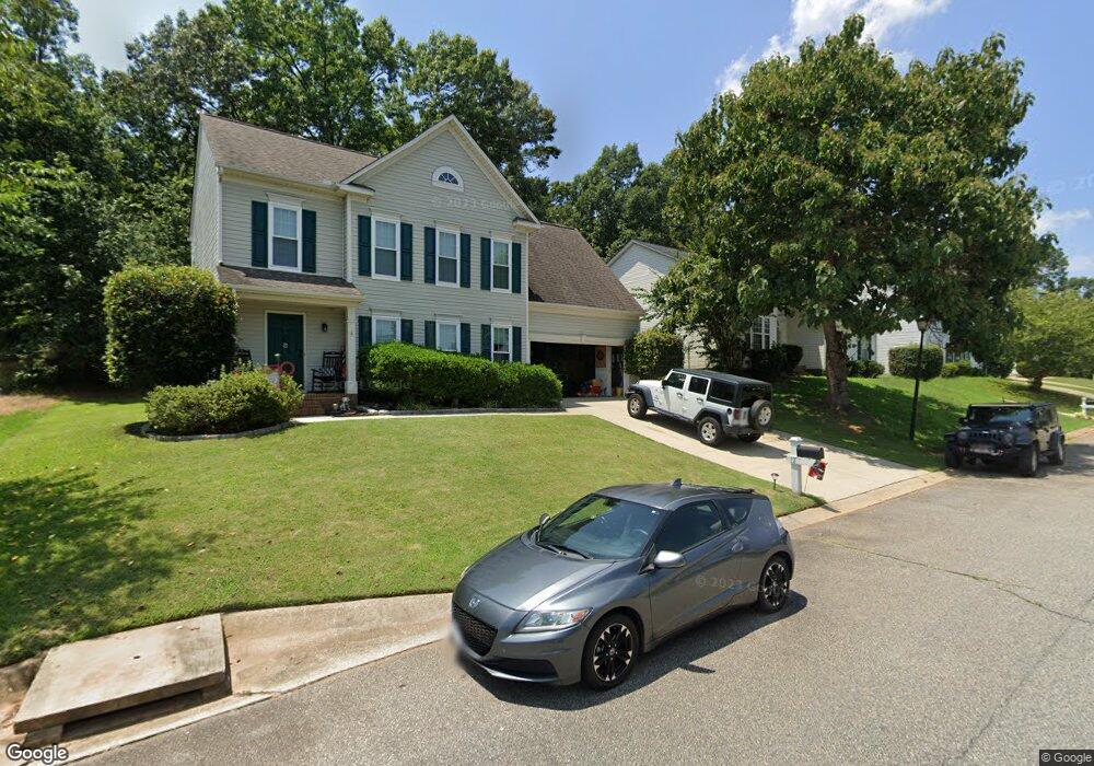
12 Renforth Rd Simpsonville, SC 29681
Estimated Value: $323,000 - $347,000
3
Beds
3
Baths
1,952
Sq Ft
$172/Sq Ft
Est. Value
About This Home
This home is located at 12 Renforth Rd, Simpsonville, SC 29681 and is currently estimated at $336,450, approximately $172 per square foot. 12 Renforth Rd is a home located in Greenville County with nearby schools including Bell's Crossing Elementary School, Hillcrest Middle School, and Hillcrest High School.
Ownership History
Date
Name
Owned For
Owner Type
Purchase Details
Closed on
Feb 25, 2005
Sold by
Ladoon Dale W
Bought by
Maloy Alison
Current Estimated Value
Home Financials for this Owner
Home Financials are based on the most recent Mortgage that was taken out on this home.
Original Mortgage
$29,000
Interest Rate
5.61%
Mortgage Type
Purchase Money Mortgage
Purchase Details
Closed on
Mar 3, 2003
Sold by
Vandeputte Thomas W
Bought by
Ladoon Dale W
Purchase Details
Closed on
Sep 25, 2001
Sold by
Nvr Inc
Bought by
Vandeputte Thomas W
Create a Home Valuation Report for This Property
The Home Valuation Report is an in-depth analysis detailing your home's value as well as a comparison with similar homes in the area
Home Values in the Area
Average Home Value in this Area
Purchase History
| Date | Buyer | Sale Price | Title Company |
|---|---|---|---|
| Maloy Alison | $145,000 | -- | |
| Ladoon Dale W | $126,400 | -- | |
| Vandeputte Thomas W | $141,110 | -- |
Source: Public Records
Mortgage History
| Date | Status | Borrower | Loan Amount |
|---|---|---|---|
| Closed | Vandeputte Thomas W | $29,000 |
Source: Public Records
Tax History
| Year | Tax Paid | Tax Assessment Tax Assessment Total Assessment is a certain percentage of the fair market value that is determined by local assessors to be the total taxable value of land and additions on the property. | Land | Improvement |
|---|---|---|---|---|
| 2025 | $26 | $14,095 | $0 | $0 |
| 2024 | $26 | $7,330 | $1,010 | $6,320 |
| 2023 | $1,160 | $7,330 | $1,010 | $6,320 |
| 2022 | $1,131 | $7,330 | $1,010 | $6,320 |
| 2021 | $1,132 | $7,330 | $1,010 | $6,320 |
| 2020 | $1,040 | $6,370 | $880 | $5,490 |
| 2019 | $1,040 | $6,370 | $880 | $5,490 |
| 2018 | $1,085 | $6,370 | $880 | $5,490 |
| 2017 | $1,087 | $6,370 | $880 | $5,490 |
| 2016 | $1,044 | $159,300 | $22,000 | $137,300 |
| 2015 | $1,046 | $159,300 | $22,000 | $137,300 |
| 2014 | $938 | $149,486 | $24,042 | $125,444 |
Source: Public Records
Map
Nearby Homes
- 104 Morell Dr
- 112 Bathurst Ln
- 5 Bathurst Ln
- 112 Brown Ln
- 220 Waters Run Ln
- 117 Moorish Cir
- 119 Moorish Cir
- 124 Moorish Cir
- 104 Brown Ln
- 135 Adams Creek Place
- 5 Kinglet Ct
- 1504 Plantation Dr
- 104 Laurel Oak Trail
- 1214 Plantation Dr
- 712 Spring Lake Loop
- 102 Spring Lake Loop
- 1202 Plantation Dr
- 9 Arabian Way
- 16 Verona Cir
- 14 Manorwood Ct
- 14 Renforth Rd
- 10 Renforth Rd
- 16 Renforth Rd
- 8 Renforth Rd
- 5 Digby Place
- 3 Digby Place
- 107 Moncton Place
- 18 Renforth Rd
- 13 Renforth Rd
- 11 Renforth Rd
- 17 Renforth Rd
- 6 Renforth Rd
- 109 Moncton Place
- 105 Moncton Place
- 8 Digby Place
- 9 Renforth Rd
- 19 Renforth Rd
- 111 Moncton Place
- 103 Moncton Place
- 7 Renforth Rd
Your Personal Tour Guide
Ask me questions while you tour the home.