Estimated Value: $1,012,000 - $1,330,000
5
Beds
2
Baths
768
Sq Ft
$1,466/Sq Ft
Est. Value
About This Home
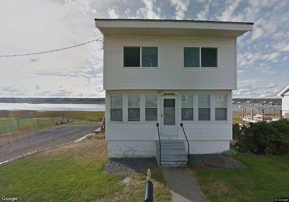
This home is located at 12 Riverside Dr, Wells, ME 04090 and is currently estimated at $1,125,813, approximately $1,465 per square foot. 12 Riverside Dr is a home located in York County with nearby schools including Wells Junior High School, Wells Elementary School, and Wells High School.
Ownership History
Date
Name
Owned For
Owner Type
Purchase Details
Closed on
Mar 28, 2019
Sold by
Sullivan Helen E
Bought by
Shine Daniel P and Shine Elizabeth A
Current Estimated Value
Purchase Details
Closed on
Aug 16, 2006
Sold by
Sullivan Helen E and Burke Joan M
Bought by
Sullivan Helen E
Create a Home Valuation Report for This Property
The Home Valuation Report is an in-depth analysis detailing your home's value as well as a comparison with similar homes in the area
Home Values in the Area
Average Home Value in this Area
Purchase History
| Date | Buyer | Sale Price | Title Company |
|---|---|---|---|
| Shine Daniel P | -- | -- | |
| Shine Daniel P | -- | -- | |
| Sullivan Helen E | -- | -- | |
| Sullivan Helen E | -- | -- |
Source: Public Records
Mortgage History
| Date | Status | Borrower | Loan Amount |
|---|---|---|---|
| Previous Owner | Sullivan Helen E | $810,000 | |
| Previous Owner | Sullivan Helen E | $10,000 | |
| Previous Owner | Sullivan Helen E | $189,000 | |
| Previous Owner | Sullivan Helen E | $158,000 |
Source: Public Records
Tax History Compared to Growth
Tax History
| Year | Tax Paid | Tax Assessment Tax Assessment Total Assessment is a certain percentage of the fair market value that is determined by local assessors to be the total taxable value of land and additions on the property. | Land | Improvement |
|---|---|---|---|---|
| 2024 | $6,285 | $1,033,680 | $828,100 | $205,580 |
| 2023 | $6,161 | $1,033,680 | $828,100 | $205,580 |
| 2022 | $6,331 | $605,270 | $485,520 | $119,750 |
| 2021 | $6,367 | $605,270 | $485,520 | $119,750 |
| 2020 | $6,343 | $605,270 | $485,520 | $119,750 |
| 2019 | $6,307 | $605,270 | $485,520 | $119,750 |
| 2018 | $6,134 | $605,270 | $485,520 | $119,750 |
| 2017 | $6,150 | $605,270 | $485,520 | $119,750 |
| 2016 | $6,089 | $605,270 | $485,520 | $119,750 |
| 2015 | $6,022 | $605,270 | $485,520 | $119,750 |
| 2013 | $5,520 | $605,270 | $485,520 | $119,750 |
Source: Public Records
Map
Nearby Homes
- 446 Atlantic Ave
- 500 Atlantic Ave Unit 2
- 9 Robert Ln
- 229 Atlantic Ave
- 225 Atlantic Ave
- 163 Island Beach Rd
- 75 Ox Cart Ln Unit 2
- 61 Atlantic Ave Unit 3
- 46 Ox Cart Ln
- 1801 Post Rd Unit 190
- 1801 Post Rd Unit 180
- 1801 Post Rd Unit 143
- 1733 Post Rd
- 1516 Post Rd
- 42 Rachel Carson Ln
- 1373 Post Rd Unit 1F
- 1373 Post Rd Unit 6B
- 1373 Post Rd Unit 10A
- 4 Tidal Ct
- 1830 Post Rd
- 16 Riverside Dr
- 20 Riverside Dr
- 400 Atlantic Ave Unit C
- 400 Atlantic Ave Unit B
- 400 Atlantic Ave Unit A
- 400 Atlantic Ave Unit D
- 396 Atlantic Ave
- 404 Atlantic Ave
- 408 Atlantic Ave
- 412 Atlantic Ave
- 388 Atlantic Ave
- 32 Riverside Dr
- 416 Atlantic Ave
- 0 Riverside Dr Unit 549095
- 0 Riverside Dr Unit 546953
- 0 Riverside Dr Unit 593693
- 0 Riverside Dr Unit 586257
- 0 Riverside Dr Unit 575333
- 0 Riverside Dr Unit 547353
- 0 Riverside Dr Unit 930466