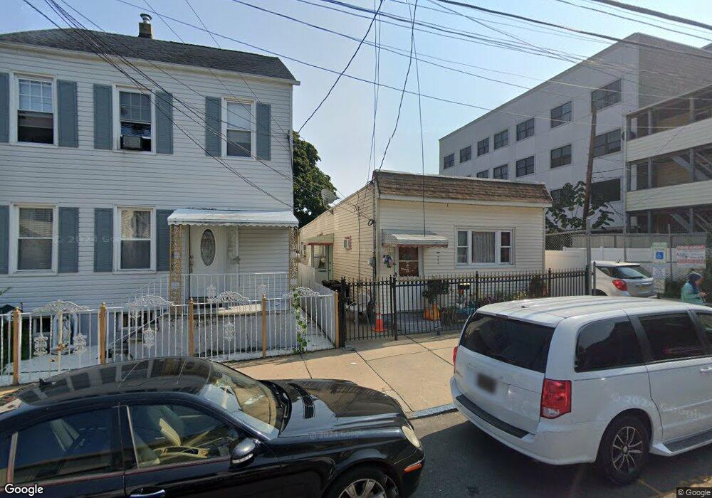
12 Thomas St Paterson, NJ 07503
South Paterson NeighborhoodEstimated Value: $308,000 - $532,000
Studio
--
Bath
958
Sq Ft
$421/Sq Ft
Est. Value
About This Home
This home is located at 12 Thomas St, Paterson, NJ 07503 and is currently estimated at $403,018, approximately $420 per square foot. 12 Thomas St is a home located in Passaic County with nearby schools including Dale Avenue Elementary School, Edward W. Kilpatrick School of Discovery, and Paterson Public School No. 3.
Ownership History
Date
Name
Owned For
Owner Type
Purchase Details
Closed on
Jul 12, 2005
Sold by
Coombs Shelly D
Bought by
Ramirez Jesus and Ramirez Matilde
Current Estimated Value
Home Financials for this Owner
Home Financials are based on the most recent Mortgage that was taken out on this home.
Original Mortgage
$116,000
Outstanding Balance
$60,208
Interest Rate
5.67%
Estimated Equity
$342,810
Create a Home Valuation Report for This Property
The Home Valuation Report is an in-depth analysis detailing your home's value as well as a comparison with similar homes in the area
Home Values in the Area
Average Home Value in this Area
Purchase History
| Date | Buyer | Sale Price | Title Company |
|---|---|---|---|
| Ramirez Jesus | $145,000 | -- |
Source: Public Records
Mortgage History
| Date | Status | Borrower | Loan Amount |
|---|---|---|---|
| Open | Ramirez Jesus | $116,000 |
Source: Public Records
Tax History
| Year | Tax Paid | Tax Assessment Tax Assessment Total Assessment is a certain percentage of the fair market value that is determined by local assessors to be the total taxable value of land and additions on the property. | Land | Improvement |
|---|---|---|---|---|
| 2025 | $6,246 | $122,600 | $41,500 | $81,100 |
| 2024 | $6,011 | $122,600 | $41,500 | $81,100 |
| 2022 | $5,691 | $122,600 | $41,500 | $81,100 |
| 2021 | $5,488 | $122,600 | $41,500 | $81,100 |
| 2020 | $5,119 | $122,600 | $41,500 | $81,100 |
| 2019 | $4,948 | $119,700 | $40,500 | $79,200 |
| 2018 | $5,109 | $118,100 | $40,100 | $78,000 |
| 2017 | $4,876 | $117,200 | $39,900 | $77,300 |
| 2016 | $5,367 | $123,700 | $42,000 | $81,700 |
| 2015 | $5,082 | $123,700 | $42,000 | $81,700 |
| 2014 | $5,986 | $206,400 | $138,500 | $67,900 |
Source: Public Records
Map
Nearby Homes
- 27 Robert St Unit 29
- 7 Montclair Ave
- 146-148 Bloomfield Ave
- 92 Bloomfield Ave
- 355-357 Getty Ave
- 357-361 Getty Ave
- 339 Paxton St
- 80 Newark Ave
- 45 Dey St
- 235 Dakota St Unit 10
- 11 Adams St
- 28 Butler St
- 35-37 Montclair Ave
- 19 Inwood St
- 65 Levine St
- 445 Marshall St
- 439 Marshall St
- 69-71 Crooks Ave
- 209 Michigan Ave Unit 211
- 148 Barclay St
- 14 Thomas St Unit 16
- 14-16 Thomas St
- 10 Thomas St
- 16 Thomas St Unit 18
- 20 Thomas St Unit 22
- 941 Main St Unit 2D
- 941 Main St
- 939 Main St Unit 4
- 939 Main St Unit 3
- 939 Main St
- 13 Thomas St Unit 17
- 933 Main St
- 941-945 Main St
- 22 Thomas St Unit 24
- 13 George St
- 947 Main St
- 15 George St Unit 17
- 19 Thomas St Unit 21
- 26 Thomas St Unit 28
- 23 Thomas St Unit 25
Your Personal Tour Guide
Ask me questions while you tour the home.