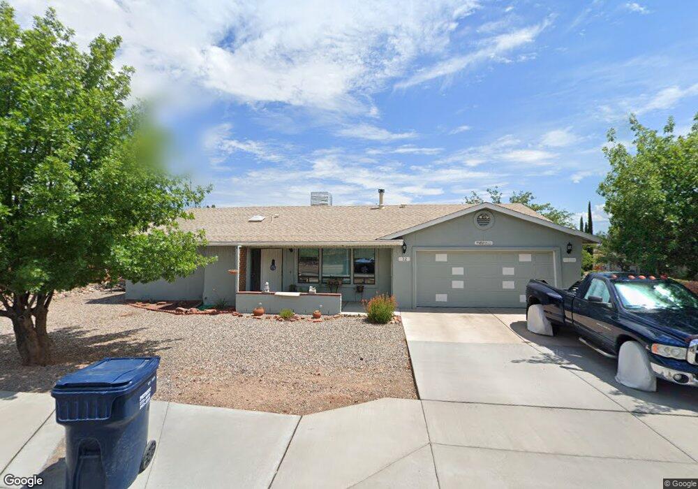
12 W Fir St Unit 8 Cottonwood, AZ 86326
Cottonwood NeighborhoodEstimated Value: $413,000 - $430,000
2
Beds
2
Baths
1,590
Sq Ft
$265/Sq Ft
Est. Value
About This Home
This home is located at 12 W Fir St Unit 8, Cottonwood, AZ 86326 and is currently estimated at $421,423, approximately $265 per square foot. 12 W Fir St Unit 8 is a home located in Yavapai County with nearby schools including Dr Daniel Bright Elementary School, Cottonwood Elementary School, and Cottonwood Community School.
Ownership History
Date
Name
Owned For
Owner Type
Purchase Details
Closed on
May 30, 2018
Sold by
Moore Arthur F and Moore Heidemarie C
Bought by
Moore Arthur F and Moore Heidemarie C
Current Estimated Value
Purchase Details
Closed on
Apr 13, 2016
Sold by
Hipp Don
Bought by
Moore Arthur F and Moore Heidemarie C
Home Financials for this Owner
Home Financials are based on the most recent Mortgage that was taken out on this home.
Original Mortgage
$139,900
Outstanding Balance
$110,996
Interest Rate
3.64%
Mortgage Type
New Conventional
Estimated Equity
$310,427
Purchase Details
Closed on
Apr 9, 1996
Sold by
Hipp Peggy Lou
Bought by
Hipp Peggy Lou
Create a Home Valuation Report for This Property
The Home Valuation Report is an in-depth analysis detailing your home's value as well as a comparison with similar homes in the area
Home Values in the Area
Average Home Value in this Area
Purchase History
| Date | Buyer | Sale Price | Title Company |
|---|---|---|---|
| Moore Arthur F | -- | None Available | |
| Moore Arthur F | $195,000 | Yavapai Title Agency Inc | |
| Hipp Peggy Lou | -- | -- |
Source: Public Records
Mortgage History
| Date | Status | Borrower | Loan Amount |
|---|---|---|---|
| Open | Moore Arthur F | $139,900 |
Source: Public Records
Tax History Compared to Growth
Tax History
| Year | Tax Paid | Tax Assessment Tax Assessment Total Assessment is a certain percentage of the fair market value that is determined by local assessors to be the total taxable value of land and additions on the property. | Land | Improvement |
|---|---|---|---|---|
| 2026 | $1,104 | $33,771 | -- | -- |
| 2024 | $1,082 | $33,361 | -- | -- |
| 2023 | $1,082 | $26,948 | $3,534 | $23,414 |
| 2022 | $1,079 | $22,164 | $2,854 | $19,310 |
| 2021 | $1,173 | $20,729 | $2,985 | $17,744 |
| 2020 | $1,165 | $0 | $0 | $0 |
| 2019 | $1,159 | $0 | $0 | $0 |
| 2018 | $1,113 | $0 | $0 | $0 |
| 2017 | $1,066 | $0 | $0 | $0 |
| 2016 | $1,048 | $0 | $0 | $0 |
| 2015 | $1,049 | $0 | $0 | $0 |
| 2014 | -- | $0 | $0 | $0 |
Source: Public Records
Map
Nearby Homes
- 1063 S Viejo Dr
- 1239 S Navajo Dr
- 304 W Mesquite Dr Unit 8
- 1191 S Vista Grande Dr
- 1041 S Vista Grande Dr
- 320 E Fir St
- 1203 S Settlers Cir Unit 8
- 609 W Fir St
- 910 S Tigres Trail
- 570 E La Jolla Cir
- 1381 S Saddleback Dr
- 807 S Tigres Trail
- 912 S 6th St
- 630 E Elm St
- 1514 S Mano Ln
- 1860 Sunset Dr
- 9 E Crimson Rd Unit Lot 18
- 421 Boulder Ln
- 601 Clover Way Unit 7
- 5 W Cottonwood St Unit 23