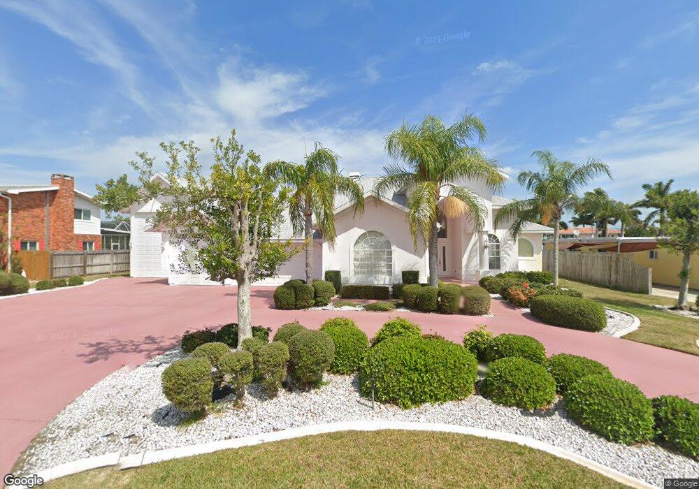
12 West Point Dr Cocoa Beach, FL 32931
Estimated Value: $1,270,062 - $1,521,000
4
Beds
3
Baths
2,536
Sq Ft
$550/Sq Ft
Est. Value
About This Home
This home is located at 12 West Point Dr, Cocoa Beach, FL 32931 and is currently estimated at $1,395,016, approximately $550 per square foot. 12 West Point Dr is a home located in Brevard County with nearby schools including Theodore Roosevelt Elementary School, Cocoa Beach Junior/Senior High School, and Cocoa Beach Christian School.
Ownership History
Date
Name
Owned For
Owner Type
Purchase Details
Closed on
Jun 22, 2021
Sold by
Krill John B
Bought by
Dempsey Martin Joseph and The Rocket Real Estate Trust
Current Estimated Value
Purchase Details
Closed on
Jan 16, 2007
Sold by
Krill John B and Krill Rose Mary
Bought by
Krill John B and Krill Rose Mary
Purchase Details
Closed on
Jul 2, 1997
Sold by
Eaton Charles V and Eaton Esther O
Bought by
Krill John B and Krill Rose Mary
Home Financials for this Owner
Home Financials are based on the most recent Mortgage that was taken out on this home.
Original Mortgage
$380,000
Interest Rate
7.98%
Create a Home Valuation Report for This Property
The Home Valuation Report is an in-depth analysis detailing your home's value as well as a comparison with similar homes in the area
Home Values in the Area
Average Home Value in this Area
Purchase History
| Date | Buyer | Sale Price | Title Company |
|---|---|---|---|
| Dempsey Martin Joseph | $1,030,000 | Dockside Title Llc | |
| Krill John B | -- | None Available | |
| Krill John B | $380,000 | -- |
Source: Public Records
Mortgage History
| Date | Status | Borrower | Loan Amount |
|---|---|---|---|
| Previous Owner | Krill John B | $380,000 |
Source: Public Records
Tax History
| Year | Tax Paid | Tax Assessment Tax Assessment Total Assessment is a certain percentage of the fair market value that is determined by local assessors to be the total taxable value of land and additions on the property. | Land | Improvement |
|---|---|---|---|---|
| 2025 | $13,992 | $1,125,790 | -- | -- |
| 2024 | $12,832 | $1,168,920 | -- | -- |
| 2023 | $12,832 | $1,025,650 | $430,000 | $595,650 |
| 2022 | $11,758 | $975,310 | $0 | $0 |
| 2021 | $5,471 | $428,500 | $0 | $0 |
| 2020 | $5,429 | $422,590 | $0 | $0 |
| 2019 | $5,398 | $413,090 | $0 | $0 |
| 2018 | $5,437 | $405,390 | $0 | $0 |
| 2017 | $5,531 | $397,060 | $0 | $0 |
| 2016 | $5,662 | $388,900 | $230,000 | $158,900 |
| 2015 | $5,861 | $386,200 | $200,000 | $186,200 |
| 2014 | $5,916 | $383,140 | $200,000 | $183,140 |
Source: Public Records
Map
Nearby Homes
- 1790 Bayshore Dr
- 1675 Bayshore Dr
- 1375 Bayshore Dr
- 2 River Falls Dr
- 1531 S Orlando Ave
- 1299 S Orlando Ave
- 2050 S Atlantic Ave
- 1277 S Orlando Ave Unit 4B
- 24 Olive St
- 1527 S Atlantic Ave Unit 201
- 1563 S Atlantic Ave Unit 13
- 1515 S Atlantic Ave Unit 404
- 1305 S Atlantic Ave Unit 110
- 1800 S Orlando Ave Unit 1
- 1700 S Atlantic Ave Unit 104
- 1139 S Brevard Ave
- 2001 Julep Dr Unit 206- 3rd Floor
- 1155 S Atlantic Ave Unit 203
- 1835 S Atlantic Ave Unit 301
- 2021 S Orlando Ave
- 12 W Point Dr
- 11 W Point Dr
- 13 West Point Dr
- 11 West Point Dr
- 13 W Point Dr
- 14 W Point Dr
- 14 West Point Dr
- 10 West Point Dr
- 24 West Point Dr
- 23 West Point Dr
- 23 W Point Dr
- 25 W Point Dr
- 25 West Point Dr
- 22 West Point Dr
- 9 W Point Dr
- 1770 Bayshore Dr
- 1754 Bayshore Dr
- 9 West Point Dr
- 22 W Point Dr
- 1800 Bayshore Dr
Your Personal Tour Guide
Ask me questions while you tour the home.