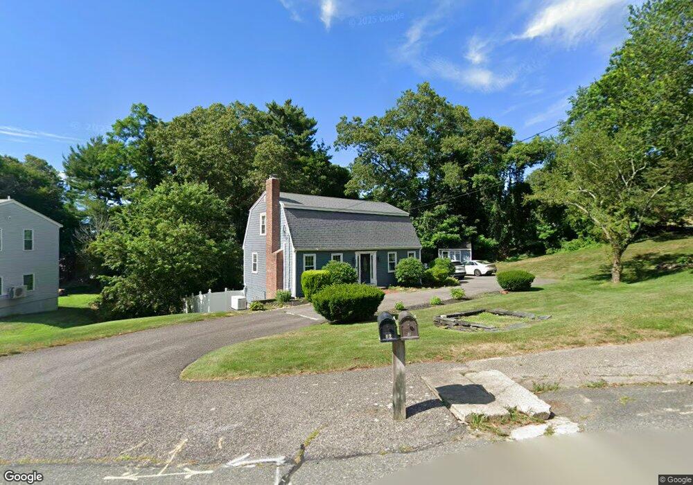
12 Whitford Cir Marshfield, MA 02050
Estimated Value: $725,367 - $831,000
3
Beds
2
Baths
1,800
Sq Ft
$445/Sq Ft
Est. Value
About This Home
This home is located at 12 Whitford Cir, Marshfield, MA 02050 and is currently estimated at $800,342, approximately $444 per square foot. 12 Whitford Cir is a home located in Plymouth County with nearby schools including Governor Edward Winslow School, Furnace Brook Middle School, and Marshfield High School.
Ownership History
Date
Name
Owned For
Owner Type
Purchase Details
Closed on
Mar 9, 2023
Sold by
Gillis Janet E
Bought by
Janet E Gillis Ret and Gillis
Current Estimated Value
Purchase Details
Closed on
Jun 25, 2004
Sold by
Kelliher James M and Kelliher Karen L
Bought by
Peterson David W and Peterson Janet E
Purchase Details
Closed on
Apr 28, 1995
Sold by
Odonnell Linda M
Bought by
Lamarca Karen M and Kelliher James M
Home Financials for this Owner
Home Financials are based on the most recent Mortgage that was taken out on this home.
Original Mortgage
$115,600
Interest Rate
8.33%
Mortgage Type
Purchase Money Mortgage
Create a Home Valuation Report for This Property
The Home Valuation Report is an in-depth analysis detailing your home's value as well as a comparison with similar homes in the area
Home Values in the Area
Average Home Value in this Area
Purchase History
| Date | Buyer | Sale Price | Title Company |
|---|---|---|---|
| Janet E Gillis Ret | -- | None Available | |
| Peterson David W | $415,500 | -- | |
| Peterson David W | $415,500 | -- | |
| Lamarca Karen M | $144,500 | -- |
Source: Public Records
Mortgage History
| Date | Status | Borrower | Loan Amount |
|---|---|---|---|
| Previous Owner | Lamarca Karen M | $110,000 | |
| Previous Owner | Lamarca Karen M | $115,600 |
Source: Public Records
Tax History
| Year | Tax Paid | Tax Assessment Tax Assessment Total Assessment is a certain percentage of the fair market value that is determined by local assessors to be the total taxable value of land and additions on the property. | Land | Improvement |
|---|---|---|---|---|
| 2025 | $6,850 | $691,900 | $303,100 | $388,800 |
| 2024 | $6,679 | $642,800 | $288,600 | $354,200 |
| 2023 | $6,403 | $565,600 | $257,700 | $307,900 |
| 2022 | $6,198 | $478,600 | $216,500 | $262,100 |
| 2021 | $5,953 | $451,300 | $216,500 | $234,800 |
| 2020 | $5,649 | $423,800 | $195,900 | $227,900 |
| 2019 | $5,480 | $409,600 | $195,900 | $213,700 |
| 2018 | $5,415 | $405,000 | $195,900 | $209,100 |
| 2017 | $5,293 | $385,800 | $195,900 | $189,900 |
| 2016 | $5,165 | $372,100 | $195,900 | $176,200 |
| 2015 | $4,884 | $367,500 | $195,900 | $171,600 |
| 2014 | $4,767 | $358,700 | $195,900 | $162,800 |
Source: Public Records
Map
Nearby Homes
- 568 Webster St
- 86 Barouche Dr
- 116 Outlook Rd
- 412 Moraine St
- 184 King Phillips Pathe
- 431 Moraine St
- 42 Carr Rd
- 242 Enterprise St
- 7 Pierce Rd
- 6 Maple Ln
- 30 Chandler Dr
- 152 Acorn St
- 92 Salt Meadow Waye
- 129 Franklin St
- 290 S River St
- 66 Simmons Dr
- 11 Simmons Dr
- 4 Rachael's Ln
- 315 Church St
- 155 Quincy Ave
- 22 Whitford Dr
- 22 Whitford Cir
- 15 Whitford Cir
- 7 Whitford Cir
- 29 Whitford Dr
- 14 Whitford Dr
- 32 Whitford Cir
- 25 Whitford Cir
- 201 Whitford Cir
- 17 Whitford Dr
- 192 Whitford Cir
- 551 Webster St
- 533 Webster St
- 33 Whitford Cir
- 6 Whitford Dr
- 99 Whitford Cir
- 91 Whitford Cir
- 189 Whitford Cir
- 509 Webster St
- 545 Webster St
Your Personal Tour Guide
Ask me questions while you tour the home.