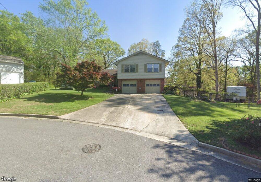
120 Ansted Ln Atlanta, GA 30349
Estimated Value: $188,000 - $263,000
3
Beds
3
Baths
1,736
Sq Ft
$134/Sq Ft
Est. Value
About This Home
This home is located at 120 Ansted Ln, Atlanta, GA 30349 and is currently estimated at $233,065, approximately $134 per square foot. 120 Ansted Ln is a home located in Fulton County with nearby schools including Nolan Elementary School, Mcnair Middle School, and Banneker High School.
Ownership History
Date
Name
Owned For
Owner Type
Purchase Details
Closed on
Sep 6, 2013
Sold by
Hayes William R
Bought by
Hayes William R and Andrews Donna Michele
Current Estimated Value
Home Financials for this Owner
Home Financials are based on the most recent Mortgage that was taken out on this home.
Original Mortgage
$50,000
Interest Rate
4.39%
Mortgage Type
New Conventional
Create a Home Valuation Report for This Property
The Home Valuation Report is an in-depth analysis detailing your home's value as well as a comparison with similar homes in the area
Home Values in the Area
Average Home Value in this Area
Purchase History
| Date | Buyer | Sale Price | Title Company |
|---|---|---|---|
| Hayes William R | -- | -- | |
| Hayes William R | -- | -- | |
| Hayes William R | -- | -- |
Source: Public Records
Mortgage History
| Date | Status | Borrower | Loan Amount |
|---|---|---|---|
| Previous Owner | Hayes William R | $50,000 |
Source: Public Records
Tax History Compared to Growth
Tax History
| Year | Tax Paid | Tax Assessment Tax Assessment Total Assessment is a certain percentage of the fair market value that is determined by local assessors to be the total taxable value of land and additions on the property. | Land | Improvement |
|---|---|---|---|---|
| 2025 | $184 | $87,440 | $13,560 | $73,880 |
| 2023 | $2,339 | $82,880 | $19,080 | $63,800 |
| 2022 | $328 | $68,200 | $15,720 | $52,480 |
| 2021 | $320 | $28,800 | $5,680 | $23,120 |
| 2020 | $318 | $28,440 | $5,600 | $22,840 |
| 2019 | $309 | $27,960 | $5,520 | $22,440 |
| 2018 | $308 | $27,320 | $5,400 | $21,920 |
| 2017 | $301 | $26,240 | $5,160 | $21,080 |
| 2016 | $300 | $26,240 | $5,160 | $21,080 |
| 2015 | $300 | $26,240 | $5,160 | $21,080 |
| 2014 | $106 | $15,720 | $3,200 | $12,520 |
Source: Public Records
Map
Nearby Homes
- 2535 Hallie Mill Rd Unit 1
- 6860 Earlhurst Rd
- 2540 Thornton Dr
- 130 W Village Ct
- 2650 Ashley Downs Ln
- 7050 Galloway Point
- 6990 Old National Hwy
- 6785 Marlborough Cir S
- 2643 Haligan Point
- 2433 Wood Bend Ln
- 0 Old National Hwy Unit 7196041
- 7041 Livia Point
- 2565 Wood Bend Ln
- 2303 Pine Tree Trail
- 1008 Pine Tree Trail
- 1901 Creel Ln
- 1006 Pine Tree Trail
- 2720 Thornbury Way
- 3206 Pine Tree Trail Unit 15C
- 110 Ansted Ln
- 130 Ansted Ln
- 130 Ansted Ln
- 2485 Hallie Mill Rd
- 2495 Hallie Mill Rd Unit 1
- 2475 Hallie Mill Rd
- 110 Hallie Ln
- 140 Ansted Ln Unit 1
- 100 Ansted Ln
- 2505 Hallie Mill Rd
- 2530 Ravencliff Rd
- 0 Ansted Ln Unit 3129567
- 0 Ansted Ln Unit 8061936
- 0 Ansted Ln
- 135 Ansted Ln
- 120 Hallie Ln
- 150 Ansted Ln
- 120 Rimel Ln Unit 1
- 100 Hallie Ln
- 2515 Hallie Mill Rd