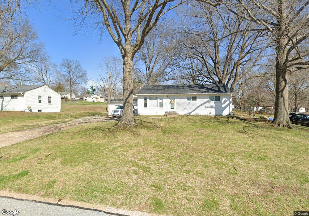
120 Applegate Ln Ballwin, MO 63011
Estimated Value: $252,000 - $279,000
3
Beds
1
Bath
1,000
Sq Ft
$267/Sq Ft
Est. Value
About This Home
This home is located at 120 Applegate Ln, Ballwin, MO 63011 and is currently estimated at $267,456, approximately $267 per square foot. 120 Applegate Ln is a home located in St. Louis County with nearby schools including Westridge Elementary School, Crestview Middle School, and Marquette Sr. High School.
Ownership History
Date
Name
Owned For
Owner Type
Purchase Details
Closed on
May 22, 2002
Sold by
Kale Pamela M and Vogelgesang Vincent E
Bought by
Vogelgesang Vincent E and Vogelgesang Pamela K
Current Estimated Value
Purchase Details
Closed on
May 22, 2001
Sold by
Kale Pamela M and Kale Gary V
Bought by
Kale Pamela M and Vogelgesang Vincent E
Home Financials for this Owner
Home Financials are based on the most recent Mortgage that was taken out on this home.
Original Mortgage
$113,400
Interest Rate
7.07%
Purchase Details
Closed on
Jul 24, 1998
Sold by
Norris Paul H and Norris Janet M
Bought by
Kale Pamela M and Kale Gary
Home Financials for this Owner
Home Financials are based on the most recent Mortgage that was taken out on this home.
Original Mortgage
$100,782
Interest Rate
6.94%
Mortgage Type
FHA
Purchase Details
Closed on
Apr 14, 1998
Sold by
Norris Paul H
Bought by
Norris Paul B and Charlene Norris Harris L
Create a Home Valuation Report for This Property
The Home Valuation Report is an in-depth analysis detailing your home's value as well as a comparison with similar homes in the area
Home Values in the Area
Average Home Value in this Area
Purchase History
| Date | Buyer | Sale Price | Title Company |
|---|---|---|---|
| Vogelgesang Vincent E | -- | -- | |
| Kale Pamela M | -- | First American Title | |
| Kale Pamela M | -- | -- | |
| Norris Paul B | -- | -- |
Source: Public Records
Mortgage History
| Date | Status | Borrower | Loan Amount |
|---|---|---|---|
| Previous Owner | Kale Pamela M | $113,400 | |
| Previous Owner | Kale Pamela M | $100,782 |
Source: Public Records
Tax History
| Year | Tax Paid | Tax Assessment Tax Assessment Total Assessment is a certain percentage of the fair market value that is determined by local assessors to be the total taxable value of land and additions on the property. | Land | Improvement |
|---|---|---|---|---|
| 2025 | $2,858 | $46,330 | $29,930 | $16,400 |
| 2024 | $2,858 | $40,700 | $21,380 | $19,320 |
| 2023 | $2,856 | $40,700 | $21,380 | $19,320 |
| 2022 | $2,575 | $34,050 | $23,520 | $10,530 |
| 2021 | $2,556 | $34,050 | $23,520 | $10,530 |
| 2020 | $2,502 | $31,770 | $17,860 | $13,910 |
| 2019 | $2,512 | $31,770 | $17,860 | $13,910 |
| 2018 | $2,432 | $28,990 | $14,060 | $14,930 |
| 2016 | $1,982 | $23,220 | $9,960 | $13,260 |
Source: Public Records
Map
Nearby Homes
- 127 Ivy Ct
- 53 Log Hill Ln
- 239 E Skyline Dr
- 112 Shirley Ln
- 131 Romine Cir
- 609 Log Hill Ct
- 634 Parker Dr
- 521 Kehrs Mill Rd
- 107 Falmouth Dr
- 815 Wendevy Ct Unit 16B
- 140 Burtonwood Dr
- 128 Shadalane Walk Unit A
- 835 Lilybud Ct Unit 5C
- 832 Wendevy Ct Unit 8B
- 807 Portsdown Rd Unit 33D
- 839 Lilybud Ct Unit 5A
- 842 Wendevy Ct
- 845 Wendevy Ct Unit 12B
- 557 Happy Ct
- 103 Denbigh Terrace
- 122 Applegate Ln
- 118 Applegate Ln
- 124 Applegate Ln
- 119 Birchwood Dr
- 116 Applegate Ln
- 121 Birchwood Dr
- 119 Applegate Ln
- 117 Applegate Ln
- 121 Applegate Ln
- 123 Birchwood Dr
- 126 Applegate Ln
- 114 Applegate Ln
- 115 Applegate Ln
- 123 Applegate Ln
- 125 Birchwood Dr
- 113 Birchwood Dr
- 125 Applegate Ln
- 113 Applegate Ln
- 128 Applegate Ln
Your Personal Tour Guide
Ask me questions while you tour the home.