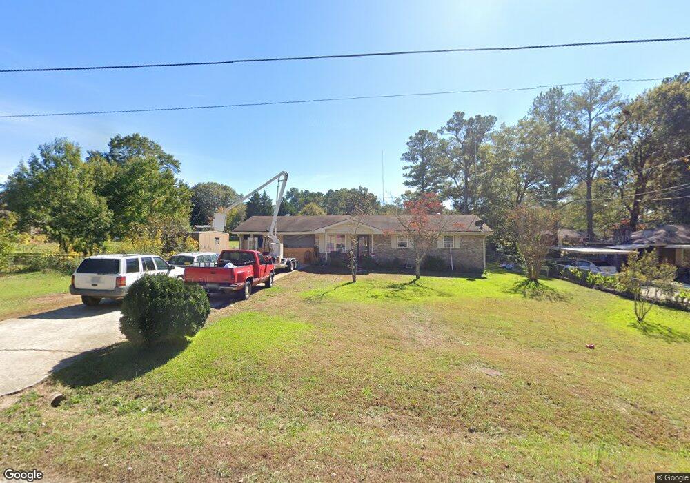
120 Carroll Cir Carrollton, GA 30117
Estimated Value: $215,000 - $229,000
3
Beds
2
Baths
1,190
Sq Ft
$187/Sq Ft
Est. Value
About This Home
This home is located at 120 Carroll Cir, Carrollton, GA 30117 and is currently estimated at $222,090, approximately $186 per square foot. 120 Carroll Cir is a home located in Carroll County with nearby schools including Carrollton Elementary School, Carrollton Upper Elementary School, and Carrollton Middle School.
Ownership History
Date
Name
Owned For
Owner Type
Purchase Details
Closed on
Aug 18, 2021
Sold by
Hardegree Martha N
Bought by
Mcdaniel Freddie Elaine and Hardegree Martha N
Current Estimated Value
Purchase Details
Closed on
Jun 4, 2021
Sold by
Tee Properties Inc
Bought by
Hardegree Martha N and Mcdaniel Freddie Elaine
Purchase Details
Closed on
Jan 1, 1989
Sold by
Jtrs Fortson J and Jtrs Louise G
Bought by
Fortson Louise G
Purchase Details
Closed on
Nov 1, 1986
Sold by
Baskos Don
Bought by
Fortson Fortson J and Fortson Louise G
Purchase Details
Closed on
Feb 18, 1977
Sold by
Cobb Lafaye
Bought by
Bakos Don
Purchase Details
Closed on
Apr 2, 1974
Sold by
Vangray Alonzo
Bought by
Cobb Lafaye
Purchase Details
Closed on
Mar 31, 1973
Sold by
Mcdowell Const Co
Bought by
Vangray Alonzo
Create a Home Valuation Report for This Property
The Home Valuation Report is an in-depth analysis detailing your home's value as well as a comparison with similar homes in the area
Home Values in the Area
Average Home Value in this Area
Purchase History
| Date | Buyer | Sale Price | Title Company |
|---|---|---|---|
| Mcdaniel Freddie Elaine | -- | -- | |
| Hardegree Martha N | $180,000 | -- | |
| Fortson Louise G | -- | -- | |
| Fortson Fortson J | $44,900 | -- | |
| Bakos Don | -- | -- | |
| Cobb Lafaye | -- | -- | |
| Vangray Alonzo | $24,000 | -- |
Source: Public Records
Tax History Compared to Growth
Tax History
| Year | Tax Paid | Tax Assessment Tax Assessment Total Assessment is a certain percentage of the fair market value that is determined by local assessors to be the total taxable value of land and additions on the property. | Land | Improvement |
|---|---|---|---|---|
| 2024 | $1,468 | $53,732 | $6,000 | $47,732 |
| 2023 | $1,468 | $49,514 | $6,000 | $43,514 |
| 2022 | $1,194 | $40,898 | $6,000 | $34,898 |
| 2021 | $1,053 | $36,065 | $6,000 | $30,065 |
| 2020 | $228 | $32,986 | $6,000 | $26,986 |
| 2019 | $223 | $30,539 | $6,000 | $24,539 |
| 2018 | $219 | $28,257 | $6,000 | $22,257 |
| 2017 | $188 | $22,660 | $6,000 | $16,660 |
| 2016 | $189 | $22,660 | $6,000 | $16,660 |
| 2015 | $207 | $24,488 | $6,000 | $18,489 |
| 2014 | $209 | $24,489 | $6,000 | $18,489 |
Source: Public Records
Map
Nearby Homes
- 0 Carroll Cir Unit LOTS 4-8 10571562
- 403 Burns Rd
- 150 Cedar Park Way
- 0 Carroll Cir- Lots 4-8 Unit 148012
- 204 Burns Rd
- 3 Burns Rd
- 2 Burns Rd
- 0 Burns Rd Unit LOT 2 10571612
- 0 Burns Rd Unit LOT 3 10571635
- 0 Burns Rd Unit LOT 1 10571595
- 0 Burns Rd Unit 148013
- 223 N Lakeshore Dr
- 231 N Lakeshore Dr
- 114 Green Point Way
- 325 Almon Rd
- 1711B Bankhead Hwy
- 123 Autumn Glen Dr
- 119 Oxford Square
- 8 Horsley Mill Rd
- 9 Horsley Mill Rd
- 122 Carroll Cir
- 112 Shannon Dr
- 118 Shannon Dr
- 118 Shannon Dr
- 118 Shannon Dr
- 118 Shannon Dr
- 118 Shannon Dr
- 148 Carroll Cir
- 150 Carroll Cir
- 124 Carroll Cir
- 146 Carroll Cir Unit 6
- 146 Carroll Cir
- 152 Carroll Cir
- 109 Carroll Cir
- 144 Carroll Cir
- 126 Carroll Cir
- 108 Shannon Dr
- 113 Shannon Dr
- 154 Carroll Cir
- 134 Carroll Cir