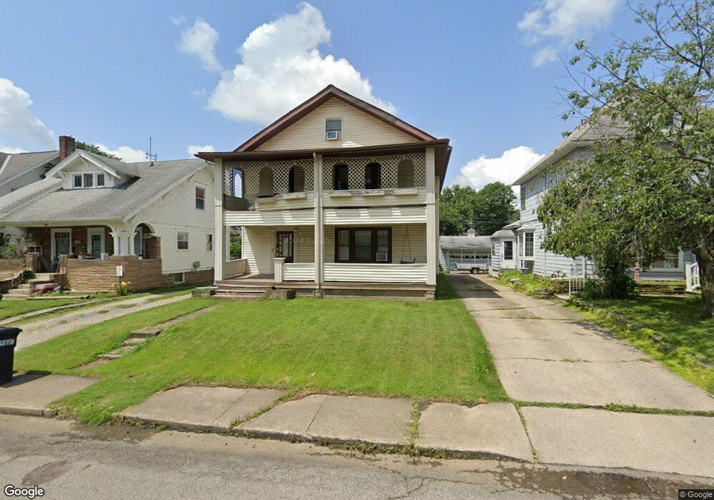
120 Dawson Ave Mansfield, OH 44906
Estimated Value: $130,000 - $146,000
4
Beds
2
Baths
2,540
Sq Ft
$54/Sq Ft
Est. Value
About This Home
This home is located at 120 Dawson Ave, Mansfield, OH 44906 and is currently estimated at $137,893, approximately $54 per square foot. 120 Dawson Ave is a home located in Richland County with nearby schools including Goal Digital Academy, St. Peter's High School/Junior High, and Discovery School.
Ownership History
Date
Name
Owned For
Owner Type
Purchase Details
Closed on
May 31, 1996
Sold by
Schaad Scott D
Bought by
Bartlett Christopher B and Bartlett Charmaine J
Current Estimated Value
Home Financials for this Owner
Home Financials are based on the most recent Mortgage that was taken out on this home.
Original Mortgage
$56,851
Interest Rate
7.99%
Mortgage Type
FHA
Purchase Details
Closed on
Apr 1, 1985
Create a Home Valuation Report for This Property
The Home Valuation Report is an in-depth analysis detailing your home's value as well as a comparison with similar homes in the area
Home Values in the Area
Average Home Value in this Area
Purchase History
| Date | Buyer | Sale Price | Title Company |
|---|---|---|---|
| Bartlett Christopher B | $56,900 | -- | |
| -- | $33,000 | -- |
Source: Public Records
Mortgage History
| Date | Status | Borrower | Loan Amount |
|---|---|---|---|
| Previous Owner | Bartlett Christopher B | $56,851 |
Source: Public Records
Tax History Compared to Growth
Tax History
| Year | Tax Paid | Tax Assessment Tax Assessment Total Assessment is a certain percentage of the fair market value that is determined by local assessors to be the total taxable value of land and additions on the property. | Land | Improvement |
|---|---|---|---|---|
| 2024 | $1,447 | $30,220 | $4,420 | $25,800 |
| 2023 | $1,447 | $30,220 | $4,420 | $25,800 |
| 2022 | $909 | $15,910 | $3,590 | $12,320 |
| 2021 | $915 | $15,910 | $3,590 | $12,320 |
| 2020 | $936 | $15,910 | $3,590 | $12,320 |
| 2019 | $1,038 | $15,910 | $3,590 | $12,320 |
| 2018 | $1,024 | $15,910 | $3,590 | $12,320 |
| 2017 | $877 | $15,910 | $3,590 | $12,320 |
| 2016 | $757 | $11,730 | $4,020 | $7,710 |
| 2015 | $723 | $11,730 | $4,020 | $7,710 |
| 2014 | $714 | $11,730 | $4,020 | $7,710 |
| 2012 | $1,239 | $27,320 | $4,020 | $23,300 |
Source: Public Records
Map
Nearby Homes
- 126 Dawson Ave
- 88 Sherman Ave
- 71 Glenwood Blvd
- 76 Bartley Ave
- 24 Stewart Ave S
- 118 Parkwood Blvd
- 21 Glenwood Blvd
- 41 Parkwood Blvd
- 38 Baldwin Ave
- 37 Baldwin Ave
- 114 Vennum Ave
- 118 Lind Ave
- 470 Woodward Ave
- 80 Rowland Ave
- 129 Fairlawn Ave
- 135 Fairlawn Ave
- 143 Fairlawn Ave
- 96 Helen Ave
- 191 Fairlawn Ave
- 679 Coleman Rd
- 126 Stewart Ave S
- 116 Dawson Ave
- 114 Dawson Ave
- 130 Dawson Ave
- 108 Dawson Ave
- 134 Dawson Ave
- 121 Stewart Ave S
- 117 Stewart Ave S
- 104 Dawson Ave
- 113 Stewart Ave S
- 136 Dawson Ave
- 127 Stewart Ave S
- 119 Dawson Ave Unit 121
- 117 Dawson Ave
- 125 Dawson Ave
- 109 Stewart Ave S
- 133 Stewart Ave S
- 115 Dawson Ave
- 129 Dawson Ave
- 142 Dawson Ave