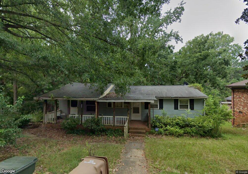
120 Dunlap St Waxhaw, NC 28173
Estimated Value: $155,000 - $297,878
3
Beds
1
Bath
1,434
Sq Ft
$151/Sq Ft
Est. Value
About This Home
This home is located at 120 Dunlap St, Waxhaw, NC 28173 and is currently estimated at $215,970, approximately $150 per square foot. 120 Dunlap St is a home located in Union County with nearby schools including Waxhaw Elementary School, Parkwood Middle School, and Parkwood High School.
Ownership History
Date
Name
Owned For
Owner Type
Purchase Details
Closed on
Mar 19, 2024
Sold by
Lewis Linda Horton and Lewis John W
Bought by
Investcar Llc
Current Estimated Value
Purchase Details
Closed on
Mar 14, 2024
Sold by
Investcar Llc
Bought by
Aly Holdings Group Llc
Purchase Details
Closed on
Jul 1, 2014
Sold by
Horton Docia Huey
Bought by
Elliott Gloria H and Lewis Linda H
Purchase Details
Closed on
Aug 14, 2002
Sold by
Horton Docia Huey
Bought by
Horton Docia Huey
Create a Home Valuation Report for This Property
The Home Valuation Report is an in-depth analysis detailing your home's value as well as a comparison with similar homes in the area
Home Values in the Area
Average Home Value in this Area
Purchase History
| Date | Buyer | Sale Price | Title Company |
|---|---|---|---|
| Investcar Llc | $145,000 | None Listed On Document | |
| Investcar Llc | $145,000 | None Listed On Document | |
| Aly Holdings Group Llc | $168,000 | None Listed On Document | |
| Aly Holdings Group Llc | $168,000 | None Listed On Document | |
| Elliott Gloria H | -- | None Available | |
| Horton Docia Huey | -- | -- |
Source: Public Records
Tax History Compared to Growth
Tax History
| Year | Tax Paid | Tax Assessment Tax Assessment Total Assessment is a certain percentage of the fair market value that is determined by local assessors to be the total taxable value of land and additions on the property. | Land | Improvement |
|---|---|---|---|---|
| 2024 | $1,528 | $149,000 | $53,100 | $95,900 |
| 2023 | $1,512 | $149,000 | $53,100 | $95,900 |
| 2022 | $1,512 | $149,000 | $53,100 | $95,900 |
| 2021 | $1,510 | $149,000 | $53,100 | $95,900 |
| 2020 | $747 | $95,330 | $21,930 | $73,400 |
| 2019 | $1,115 | $95,330 | $21,930 | $73,400 |
| 2018 | $748 | $95,330 | $21,930 | $73,400 |
| 2017 | $1,127 | $95,300 | $21,900 | $73,400 |
| 2016 | $1,108 | $95,330 | $21,930 | $73,400 |
| 2015 | $776 | $95,330 | $21,930 | $73,400 |
| 2014 | $526 | $74,870 | $21,670 | $53,200 |
Source: Public Records
Map
Nearby Homes
- 8388 Waxhaw Hwy
- 8256 Waxhaw Hwy
- 639 Boxcar Bend
- 6369 S Providence St
- 113 Dawn View Ln
- 403 Old Town Village Rd
- 309 Old Town Village Rd
- Duncan Plan at Old Town Village
- Wilson Plan at Old Town Village
- Price Plan at Old Town Village
- Hudson Plan at Old Town Village
- 305 Mckibben St
- 412 Old Town Village Rd
- 416 Old Town Village Rd
- 8215 N Carolina 75
- 432 Old Town Village Rd
- 317 Old Town Village Rd
- 451 Old Town Village Rd
- 106 Arbor Dr
- 3415 Waxhaw Indian Trail Rd S
- 116 Dunlap St
- 00 Cureton St
- 108 Dunlap St
- 638 Howie Mine Rd
- 612 Howie Mine Rd
- 616 Howie Mine Rd
- 8616 Union Central Ct
- 8620 Union Central Ct
- 104 Dunlap St
- 8604 Union Central Ct Unit 17
- 8600 Union Central Ct Unit 18
- 108 Howie Mine Rd
- 627 Howie Mine Rd
- 629 Howie Mine Rd
- 8520 Union Central Ct
- 8516 Union Central Ct
- 8609 Union Central Ct
- 8512 Union Central Ct
- 8613 Union Central Ct
- 8605 Union Central Ct