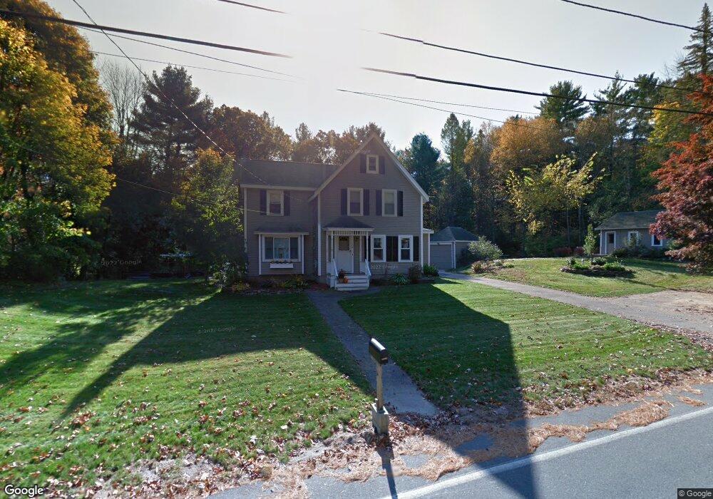
120 Mill St Hopedale, MA 01747
Estimated Value: $605,000 - $680,000
3
Beds
2
Baths
2,259
Sq Ft
$282/Sq Ft
Est. Value
About This Home
This home is located at 120 Mill St, Hopedale, MA 01747 and is currently estimated at $636,005, approximately $281 per square foot. 120 Mill St is a home located in Worcester County with nearby schools including Memorial Elementary School, Hopedale Jr Sr High School, and Bethany Christian Academy.
Ownership History
Date
Name
Owned For
Owner Type
Purchase Details
Closed on
Feb 7, 2019
Sold by
Watson Timothy J
Bought by
Watson Timothy J and Watson Marianne A
Current Estimated Value
Purchase Details
Closed on
Mar 30, 2009
Sold by
Rae Marion F and Frances Rae M
Bought by
Orff-Jacaruso Janet
Home Financials for this Owner
Home Financials are based on the most recent Mortgage that was taken out on this home.
Original Mortgage
$263,700
Interest Rate
5.14%
Mortgage Type
Purchase Money Mortgage
Create a Home Valuation Report for This Property
The Home Valuation Report is an in-depth analysis detailing your home's value as well as a comparison with similar homes in the area
Home Values in the Area
Average Home Value in this Area
Purchase History
| Date | Buyer | Sale Price | Title Company |
|---|---|---|---|
| Watson Timothy J | -- | -- | |
| Orff-Jacaruso Janet | $220,000 | -- |
Source: Public Records
Mortgage History
| Date | Status | Borrower | Loan Amount |
|---|---|---|---|
| Previous Owner | Orff-Jacaruso Janet | $263,700 |
Source: Public Records
Tax History Compared to Growth
Tax History
| Year | Tax Paid | Tax Assessment Tax Assessment Total Assessment is a certain percentage of the fair market value that is determined by local assessors to be the total taxable value of land and additions on the property. | Land | Improvement |
|---|---|---|---|---|
| 2025 | $9,425 | $567,400 | $176,900 | $390,500 |
| 2024 | $9,123 | $549,600 | $168,500 | $381,100 |
| 2023 | $8,101 | $501,600 | $165,800 | $335,800 |
| 2022 | $7,936 | $463,800 | $152,000 | $311,800 |
| 2021 | $7,563 | $423,200 | $138,100 | $285,100 |
| 2020 | $7,105 | $408,100 | $138,100 | $270,000 |
| 2019 | $6,573 | $374,100 | $132,100 | $242,000 |
| 2018 | $6,355 | $361,500 | $126,100 | $235,400 |
| 2017 | $5,880 | $340,100 | $119,300 | $220,800 |
| 2016 | $5,508 | $327,300 | $119,300 | $208,000 |
| 2015 | $5,316 | $320,600 | $119,300 | $201,300 |
Source: Public Records
Map
Nearby Homes
- 164 Greene St
- 2 Crestview Dr
- 108 Laurelwood Dr Unit 108
- 11 Heron Ln
- 25 Bens Way
- 23 Bens Way
- The Brooklyn Plan at Harmony - Subdivision
- The Meadow Plan at Harmony - Subdivision
- The Layla Plan at Harmony - Subdivision
- The Ashley Plan at Harmony - Subdivision
- The Everleigh Plan at Harmony - Subdivision
- The Tucker Plan at Harmony - Subdivision
- The Iris Plan at Harmony - Subdivision
- 29 Harmony Trail
- 3 Birch Cir
- 26 Brookview Ln Unit 26
- 211A S Main St
- 6 Mellen St
- 267 S Main St
- 256 S Main St
- 123 Mill St
- 119 Mill St
- 113 Mill St Unit 115
- 113-115 Mill St Unit 113
- 108 Mill St Unit 110
- 125 Mill St
- 136 Mill St
- 110 Mill St Unit 110
- 129 Mill St
- 100 Mill St Unit 102
- 140 Mill St
- 142 Mill St
- 131 Mill St
- 220 Laurelwood Dr
- 219 Laurelwood Dr
- 218 Laurelwood Dr
- 220 Laurelwood Dr Unit 220
- 219 Laurelwood Dr Unit 219
- 0 Laurelwood Dr Unit D 72423318
- 0 Laurelwood Dr Unit E 72409759