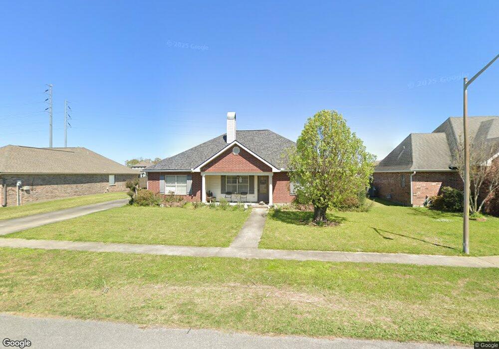
120 Nicole Dr Youngsville, LA 70592
Estimated Value: $261,000 - $284,000
--
Bed
--
Bath
1,811
Sq Ft
$150/Sq Ft
Est. Value
About This Home
This home is located at 120 Nicole Dr, Youngsville, LA 70592 and is currently estimated at $272,448, approximately $150 per square foot. 120 Nicole Dr is a home located in Lafayette Parish with nearby schools including Green T. Lindon Elementary School, Youngsville Middle School, and Southside High School.
Ownership History
Date
Name
Owned For
Owner Type
Purchase Details
Closed on
Nov 12, 2014
Sold by
Baudry Purtle Kenneth Ray and Baudry Purtle Amy
Bought by
Thompson Mark D and Thompson Melanie S
Current Estimated Value
Home Financials for this Owner
Home Financials are based on the most recent Mortgage that was taken out on this home.
Original Mortgage
$215,650
Outstanding Balance
$166,465
Interest Rate
4.21%
Mortgage Type
New Conventional
Estimated Equity
$105,983
Create a Home Valuation Report for This Property
The Home Valuation Report is an in-depth analysis detailing your home's value as well as a comparison with similar homes in the area
Home Values in the Area
Average Home Value in this Area
Purchase History
| Date | Buyer | Sale Price | Title Company |
|---|---|---|---|
| Thompson Mark D | $227,000 | Dsld Title Llc |
Source: Public Records
Mortgage History
| Date | Status | Borrower | Loan Amount |
|---|---|---|---|
| Open | Thompson Mark D | $215,650 |
Source: Public Records
Tax History Compared to Growth
Tax History
| Year | Tax Paid | Tax Assessment Tax Assessment Total Assessment is a certain percentage of the fair market value that is determined by local assessors to be the total taxable value of land and additions on the property. | Land | Improvement |
|---|---|---|---|---|
| 2024 | $1,588 | $22,926 | $2,100 | $20,826 |
| 2023 | $1,588 | $22,021 | $2,100 | $19,921 |
| 2022 | $2,162 | $22,021 | $2,100 | $19,921 |
| 2021 | $2,169 | $22,021 | $2,100 | $19,921 |
| 2020 | $2,168 | $22,021 | $2,100 | $19,921 |
| 2019 | $1,197 | $22,021 | $2,100 | $19,921 |
| 2018 | $1,481 | $22,021 | $2,100 | $19,921 |
| 2017 | $1,479 | $22,021 | $2,100 | $19,921 |
| 2015 | $1,174 | $20,210 | $2,100 | $18,110 |
| 2013 | -- | $18,870 | $2,100 | $16,770 |
Source: Public Records
Map
Nearby Homes
- 202 Rue Cordorcet
- 209 Rue Cordorcet
- 224 Tall Oaks Ln
- 133 Peak Run
- 206 Oak Hill Ln
- 204 Verger Dr
- 200 Oak Hill Ln
- 101 Verger Dr
- 4304 Chemin Metairie Pkwy Unit 5
- 4308 Chemin Metairie Pkwy Unit 6
- 4309 Chemin Metairie Pkwy Unit 1
- 4300 Chemin Metairie Pkwy Unit 4
- 4301 Chemin Metairie Pkwy Unit 3
- 4305 Chemin Metairie Pkwy Unit 2
- 206 Green Ridge Dr
- 203 Bennington Ln
- 202 Bennington Ln
- 101 Peak Run
- 3030 Chemin Metairie Pkwy
- 403 Hill Ridge Dr