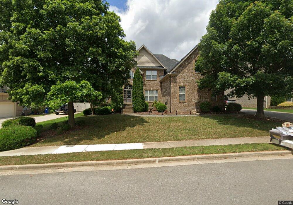
120 Ramsbrook Dr Madison, AL 35757
Harvest-Cluttsville NeighborhoodEstimated Value: $437,000 - $552,000
Studio
--
Bath
2,060
Sq Ft
$243/Sq Ft
Est. Value
About This Home
This home is located at 120 Ramsbrook Dr, Madison, AL 35757 and is currently estimated at $500,132, approximately $242 per square foot. 120 Ramsbrook Dr is a home with nearby schools including Endeavor Elementary School, Monrovia Middle School, and Sparkman High School.
Ownership History
Date
Name
Owned For
Owner Type
Purchase Details
Closed on
May 25, 2007
Sold by
Killian Home Builders Llc
Bought by
Lindley Joshua M
Current Estimated Value
Home Financials for this Owner
Home Financials are based on the most recent Mortgage that was taken out on this home.
Original Mortgage
$339,925
Outstanding Balance
$205,754
Interest Rate
6.17%
Mortgage Type
New Conventional
Estimated Equity
$294,378
Create a Home Valuation Report for This Property
The Home Valuation Report is an in-depth analysis detailing your home's value as well as a comparison with similar homes in the area
Home Values in the Area
Average Home Value in this Area
Purchase History
| Date | Buyer | Sale Price | Title Company |
|---|---|---|---|
| Lindley Joshua M | -- | -- |
Source: Public Records
Mortgage History
| Date | Status | Borrower | Loan Amount |
|---|---|---|---|
| Open | Lindley Joshua M | $339,925 |
Source: Public Records
Tax History
| Year | Tax Paid | Tax Assessment Tax Assessment Total Assessment is a certain percentage of the fair market value that is determined by local assessors to be the total taxable value of land and additions on the property. | Land | Improvement |
|---|---|---|---|---|
| 2025 | $1,793 | $51,060 | $7,500 | $43,560 |
| 2024 | $1,793 | $49,540 | $7,500 | $42,040 |
| 2023 | $1,738 | $48,040 | $7,500 | $40,540 |
| 2022 | $1,511 | $43,320 | $7,500 | $35,820 |
| 2021 | $1,318 | $37,800 | $4,500 | $33,300 |
| 2020 | $1,236 | $35,560 | $4,500 | $31,060 |
| 2019 | $1,185 | $34,160 | $4,500 | $29,660 |
| 2018 | $1,101 | $31,860 | $0 | $0 |
| 2017 | $1,101 | $31,860 | $0 | $0 |
| 2016 | $1,101 | $31,860 | $0 | $0 |
| 2015 | $1,101 | $31,860 | $0 | $0 |
| 2014 | $1,163 | $33,560 | $0 | $0 |
Source: Public Records
Map
Nearby Homes
- 108 Bilton Dr
- 204 NW Hawks Crest Dr
- 301 Kenneth Blvd NW
- 222 Legendwood Dr NW
- 306 Kenneth Blvd NW
- 203 Allegro Cir
- 372 Clutts Rd
- 209 Allegro Cir
- 213 Bumper Crop Ln NW
- 120 Flintridge Dr
- 128 Flintridge Dr
- 609 Quiet Creek Cir NW
- 134 Flintridge Dr
- 313 Pecos Ridge Cir
- 403 Ledgeway Dr
- 410 Ledgeway Dr
- 412 Ledgeway Dr
- 414 Ledgeway Dr
- 409 Ledgeway Dr
- 319 Pecos Ridge Cir
- 118 Ramsbrook Dr
- 122 Ramsbrook Dr
- 116 Ramsbrook Dr
- 125 Ramsbrook Dr
- 101 Carthage Ct
- 124 Ramsbrook Dr
- 114 Ramsbrook Dr
- 114 Ramsbrook Dr
- 126 Ramsbrook Dr
- 131 Ramsbrook Dr
- 103 Carthage Ct
- 128 Ramsbrook Dr
- 100 Carthage Ct
- 112 Ramsbrook Dr
- 130 Ramsbrook Dr
- 133 Ramsbrook Dr
- 105 Carthage Ct
- 102 Carthage Ct
- 132 Ramsbrook Dr
- 110 Ramsbrook Dr
Your Personal Tour Guide
Ask me questions while you tour the home.