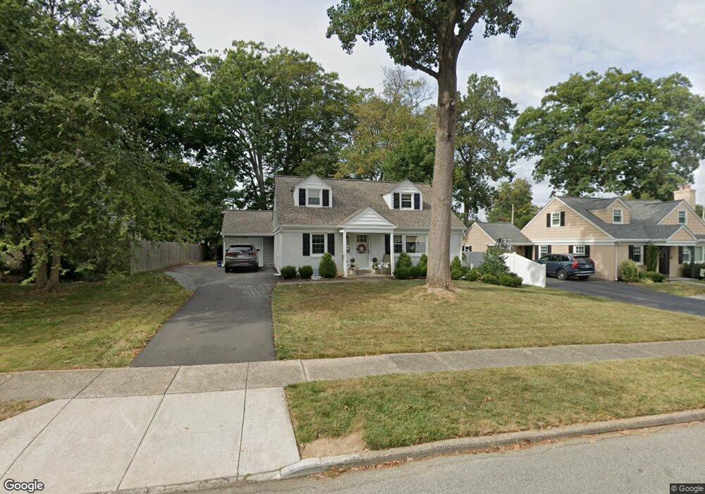
120 Rodney Cir Bryn Mawr, PA 19010
Estimated Value: $641,000 - $811,000
4
Beds
2
Baths
1,767
Sq Ft
$428/Sq Ft
Est. Value
About This Home
This home is located at 120 Rodney Cir, Bryn Mawr, PA 19010 and is currently estimated at $756,025, approximately $427 per square foot. 120 Rodney Cir is a home located in Delaware County with nearby schools including Coopertown Elementary School, Haverford Middle School, and Haverford Senior High School.
Ownership History
Date
Name
Owned For
Owner Type
Purchase Details
Closed on
Nov 29, 2021
Sold by
Eggers Vicki S and Yore Timothy L
Bought by
Gleeton Patrick and Gleeton Lauren
Current Estimated Value
Home Financials for this Owner
Home Financials are based on the most recent Mortgage that was taken out on this home.
Original Mortgage
$444,000
Outstanding Balance
$408,254
Interest Rate
3.09%
Mortgage Type
New Conventional
Estimated Equity
$347,771
Purchase Details
Closed on
May 20, 2021
Sold by
Strieb Christine and Greenwood William J
Bought by
Eggers Vicki S and Yohe Timothy L
Purchase Details
Closed on
Nov 14, 2003
Sold by
Rundell Marjorie and Saltarelli Mollie
Bought by
Greenwood William J
Purchase Details
Closed on
Jul 6, 2001
Sold by
Greenwood Fern A
Bought by
Greenwood Fern A and Fern A Greenwood Trust
Create a Home Valuation Report for This Property
The Home Valuation Report is an in-depth analysis detailing your home's value as well as a comparison with similar homes in the area
Home Values in the Area
Average Home Value in this Area
Purchase History
| Date | Buyer | Sale Price | Title Company |
|---|---|---|---|
| Gleeton Patrick | $635,000 | None Available | |
| Eggers Vicki S | $88,000 | Community Setmnt Harrisburg | |
| Greenwood William J | -- | -- | |
| Greenwood Fern A | -- | -- |
Source: Public Records
Mortgage History
| Date | Status | Borrower | Loan Amount |
|---|---|---|---|
| Open | Gleeton Patrick | $444,000 |
Source: Public Records
Tax History Compared to Growth
Tax History
| Year | Tax Paid | Tax Assessment Tax Assessment Total Assessment is a certain percentage of the fair market value that is determined by local assessors to be the total taxable value of land and additions on the property. | Land | Improvement |
|---|---|---|---|---|
| 2025 | $10,258 | $398,960 | $132,550 | $266,410 |
| 2024 | $10,258 | $398,960 | $132,550 | $266,410 |
| 2023 | $9,967 | $398,960 | $132,550 | $266,410 |
| 2022 | $9,734 | $398,960 | $132,550 | $266,410 |
| 2021 | $15,858 | $398,960 | $132,550 | $266,410 |
| 2020 | $8,884 | $191,150 | $67,560 | $123,590 |
| 2019 | $8,720 | $191,150 | $67,560 | $123,590 |
| 2018 | $8,571 | $191,150 | $0 | $0 |
| 2017 | $8,389 | $191,150 | $0 | $0 |
| 2016 | $1,049 | $191,150 | $0 | $0 |
| 2015 | $1,070 | $191,150 | $0 | $0 |
| 2014 | $1,070 | $191,150 | $0 | $0 |
Source: Public Records
Map
Nearby Homes
- 128 Clemson Rd
- 145 Landover Rd
- 173 Clemson Rd
- 258 Lee Cir
- 741 County Line Rd
- 732 Buck Ln
- 815 Penn St
- 14 Westview Rd
- 75 S Merion Ave
- 390 S Bryn Mawr Ave
- 50 Prospect Ave
- 27 S Merion Ave
- 53 Parkridge Dr
- 28 S Warner Ave
- 62 Parkridge Dr Unit 62
- 67 Parkridge Dr
- 307 B B000 Summit Dr Unit B
- 202 Summit Dr Unit B
- 103 Summit Dr Unit B
- 215 Cornell Dr