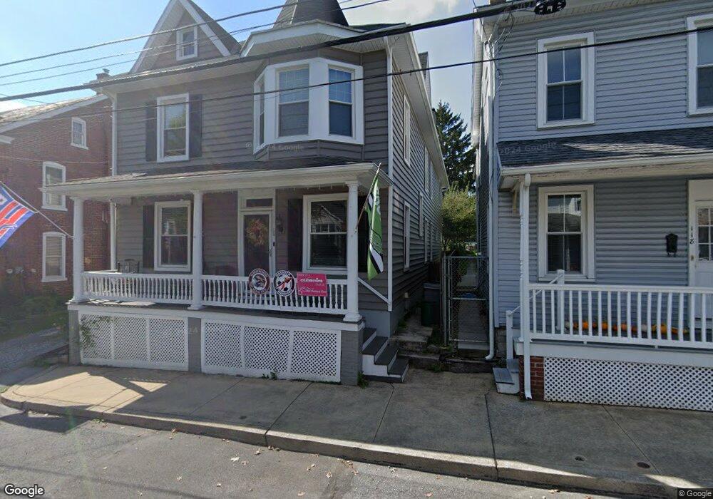
120 S Cedar St Lititz, PA 17543
Estimated Value: $527,765 - $654,000
4
Beds
3
Baths
3,120
Sq Ft
$189/Sq Ft
Est. Value
About This Home
This home is located at 120 S Cedar St, Lititz, PA 17543 and is currently estimated at $589,191, approximately $188 per square foot. 120 S Cedar St is a home located in Lancaster County with nearby schools including Warwick Senior High School, Lititz Christian School, and Linden Hall.
Ownership History
Date
Name
Owned For
Owner Type
Purchase Details
Closed on
May 17, 2011
Sold by
Sensenig Mark E and Sensenig Catherine
Bought by
Pluta Michael P and Pluta Maura E
Current Estimated Value
Home Financials for this Owner
Home Financials are based on the most recent Mortgage that was taken out on this home.
Original Mortgage
$211,850
Outstanding Balance
$147,226
Interest Rate
4.88%
Mortgage Type
New Conventional
Estimated Equity
$441,965
Purchase Details
Closed on
Sep 29, 2010
Sold by
More Susan J and Lefever Mary Carolyn
Bought by
Sensenig Mark E
Home Financials for this Owner
Home Financials are based on the most recent Mortgage that was taken out on this home.
Original Mortgage
$90,000
Interest Rate
4.44%
Mortgage Type
Purchase Money Mortgage
Create a Home Valuation Report for This Property
The Home Valuation Report is an in-depth analysis detailing your home's value as well as a comparison with similar homes in the area
Home Values in the Area
Average Home Value in this Area
Purchase History
| Date | Buyer | Sale Price | Title Company |
|---|---|---|---|
| Pluta Michael P | $223,000 | None Available | |
| Sensenig Mark E | $105,000 | None Available |
Source: Public Records
Mortgage History
| Date | Status | Borrower | Loan Amount |
|---|---|---|---|
| Open | Pluta Michael P | $211,850 | |
| Previous Owner | Sensenig Mark E | $90,000 |
Source: Public Records
Tax History Compared to Growth
Tax History
| Year | Tax Paid | Tax Assessment Tax Assessment Total Assessment is a certain percentage of the fair market value that is determined by local assessors to be the total taxable value of land and additions on the property. | Land | Improvement |
|---|---|---|---|---|
| 2025 | $5,210 | $230,300 | $48,700 | $181,600 |
| 2024 | $5,210 | $230,300 | $48,700 | $181,600 |
| 2023 | $5,189 | $230,300 | $48,700 | $181,600 |
| 2022 | $4,901 | $230,300 | $48,700 | $181,600 |
| 2021 | $4,901 | $230,300 | $48,700 | $181,600 |
| 2020 | $3,801 | $178,600 | $48,700 | $129,900 |
| 2019 | $3,801 | $178,600 | $48,700 | $129,900 |
| 2018 | $2,924 | $178,600 | $48,700 | $129,900 |
| 2017 | $3,488 | $128,800 | $31,600 | $97,200 |
| 2016 | $3,488 | $128,800 | $31,600 | $97,200 |
| 2015 | $816 | $128,800 | $31,600 | $97,200 |
| 2014 | $2,539 | $128,800 | $31,600 | $97,200 |
Source: Public Records
Map
Nearby Homes
- 44 E Center St
- 256 Cedar St S
- 133 S Spruce St
- LOT 12 Thaton Rd
- LOT 14 Thaton Rd
- 131 N Cedar St
- 128 E New St
- 421 Laurel Ave
- 301 S Locust St
- 129 Forney Dr
- 34 E Market St
- 47 W Lincoln Ave
- 417 Woodcrest Ave
- 409 Hensley St
- 601 E Main St
- 210 Noble St
- 319 N Broad St
- 398 Hensley St
- 108 Meadows Bend
- 394 Hensley St