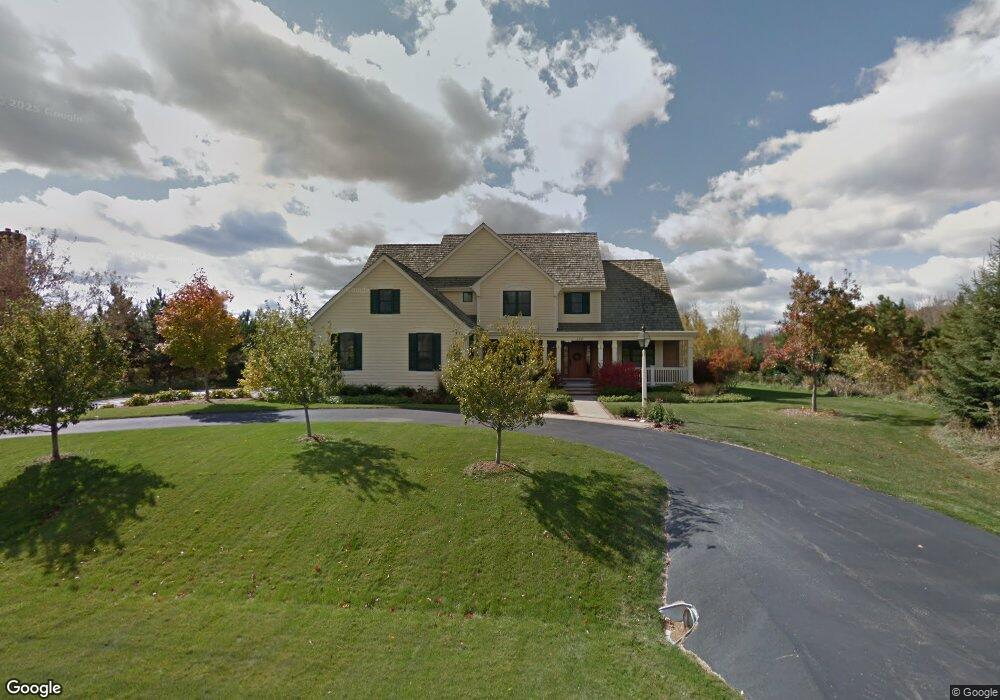
120 S Laurel Cir Delafield, WI 53018
Estimated Value: $1,386,000 - $1,572,000
5
Beds
5
Baths
--
Sq Ft
1.51
Acres
About This Home
This home is located at 120 S Laurel Cir, Delafield, WI 53018 and is currently estimated at $1,462,265. 120 S Laurel Cir is a home located in Waukesha County with nearby schools including Cushing Elementary School, Kettle Moraine Middle School, and Kettle Moraine High School.
Ownership History
Date
Name
Owned For
Owner Type
Purchase Details
Closed on
Oct 17, 2007
Sold by
Loepfe Robert P and Loepfe Carola C
Bought by
Thompson Michael A and Thompson Kelly M
Current Estimated Value
Home Financials for this Owner
Home Financials are based on the most recent Mortgage that was taken out on this home.
Original Mortgage
$768,000
Outstanding Balance
$486,715
Interest Rate
6.5%
Mortgage Type
Purchase Money Mortgage
Estimated Equity
$975,550
Purchase Details
Closed on
Sep 21, 2007
Sold by
Bostrom Elizabeth
Bought by
Loepfe Robert P and Loepfe Carola C
Home Financials for this Owner
Home Financials are based on the most recent Mortgage that was taken out on this home.
Original Mortgage
$768,000
Outstanding Balance
$486,715
Interest Rate
6.5%
Mortgage Type
Purchase Money Mortgage
Estimated Equity
$975,550
Create a Home Valuation Report for This Property
The Home Valuation Report is an in-depth analysis detailing your home's value as well as a comparison with similar homes in the area
Home Values in the Area
Average Home Value in this Area
Purchase History
| Date | Buyer | Sale Price | Title Company |
|---|---|---|---|
| Thompson Michael A | $960,900 | None Available | |
| Loepfe Robert P | -- | None Available |
Source: Public Records
Mortgage History
| Date | Status | Borrower | Loan Amount |
|---|---|---|---|
| Open | Thompson Michael A | $768,000 |
Source: Public Records
Tax History Compared to Growth
Tax History
| Year | Tax Paid | Tax Assessment Tax Assessment Total Assessment is a certain percentage of the fair market value that is determined by local assessors to be the total taxable value of land and additions on the property. | Land | Improvement |
|---|---|---|---|---|
| 2024 | $16,207 | $1,207,600 | $188,500 | $1,019,100 |
| 2023 | $15,799 | $1,207,600 | $188,500 | $1,019,100 |
| 2022 | $15,198 | $1,207,600 | $188,500 | $1,019,100 |
| 2021 | $14,889 | $921,800 | $158,300 | $763,500 |
| 2020 | $14,955 | $921,800 | $158,300 | $763,500 |
| 2019 | $14,295 | $921,800 | $158,300 | $763,500 |
| 2018 | $13,947 | $921,800 | $158,300 | $763,500 |
| 2017 | $13,811 | $921,800 | $158,300 | $763,500 |
| 2016 | $14,040 | $921,800 | $158,300 | $763,500 |
| 2015 | $14,513 | $921,800 | $158,300 | $763,500 |
| 2014 | $15,262 | $921,800 | $158,300 | $763,500 |
| 2013 | $15,262 | $929,600 | $159,900 | $769,700 |
Source: Public Records
Map
Nearby Homes
- 389 Juniper Ct
- 1958 Hillcrest Dr
- 2937 N Mill Rd
- 372 Birch Rd
- 34352 Valley Rd
- 708 Lake St
- 805 Wells St Unit 4
- 805 Wells St Unit 2
- 805 Wells St Unit 3
- 805 Wells St Unit 1
- 711 Division St
- 351 Stocks Dr
- 1001 Park Way
- 1026 Park Way
- 1025 Park Way
- 3127 Monona Ct
- 637 1st St
- N42W33349 Glen View Ct
- N41W32881 Neptune Bight
- 1603 Milwaukee St
- 121 S Laurel Cir
- 125 S Laurel Cir
- 126 S Laurel Cir
- 129 S Laurel Cir
- 191 N Fieldstone Rd
- 130 S Laurel Cir
- 150 N Fieldstone Rd
- 133 S Laurel Cir
- 180 N Fieldstone Rd
- 138 S Laurel Cir
- 280 Spruce Ct
- 141 S Laurel Cir
- 300 Spruce Ct Unit Lt55
- 300 Spruce Ct Unit 300
- 320 Spruce Ct Unit Lt54
- 320 Spruce Ct Unit 320
- 142 S Laurel Cir
- 174 N Fieldstone Rd
- 190 Spruce Ct Unit Lt60
- 260 Spruce Ct Unit Lt57