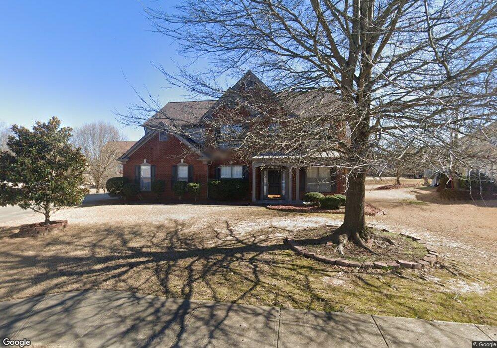
120 Splinter Ct Suwanee, GA 30024
Estimated Value: $687,000 - $738,000
4
Beds
3
Baths
2,800
Sq Ft
$253/Sq Ft
Est. Value
About This Home
This home is located at 120 Splinter Ct, Suwanee, GA 30024 and is currently estimated at $707,748, approximately $252 per square foot. 120 Splinter Ct is a home located in Fulton County with nearby schools including Shakerag Elementary School, River Trail Middle School, and Northview High School.
Ownership History
Date
Name
Owned For
Owner Type
Purchase Details
Closed on
May 29, 2003
Sold by
Kayarthodi Raviprakasha R
Bought by
Kayarthodi Raviprakasha R and Kayarthodi Shubhalaxmi
Current Estimated Value
Home Financials for this Owner
Home Financials are based on the most recent Mortgage that was taken out on this home.
Original Mortgage
$209,080
Interest Rate
5.79%
Mortgage Type
New Conventional
Create a Home Valuation Report for This Property
The Home Valuation Report is an in-depth analysis detailing your home's value as well as a comparison with similar homes in the area
Purchase History
| Date | Buyer | Sale Price | Title Company |
|---|---|---|---|
| Kayarthodi Raviprakasha R | -- | -- | |
| Kayarthodi Raviprakasha R | $261,400 | -- |
Source: Public Records
Mortgage History
| Date | Status | Borrower | Loan Amount |
|---|---|---|---|
| Previous Owner | Kayarthodi Raviprakasha R | $209,080 |
Source: Public Records
Tax History
| Year | Tax Paid | Tax Assessment Tax Assessment Total Assessment is a certain percentage of the fair market value that is determined by local assessors to be the total taxable value of land and additions on the property. | Land | Improvement |
|---|---|---|---|---|
| 2025 | $3,951 | $282,600 | $64,960 | $217,640 |
| 2023 | $6,402 | $226,800 | $68,920 | $157,880 |
| 2022 | $3,763 | $175,840 | $35,760 | $140,080 |
| 2021 | $3,725 | $146,080 | $40,480 | $105,600 |
| 2020 | $3,745 | $142,120 | $43,840 | $98,280 |
| 2019 | $427 | $139,560 | $43,040 | $96,520 |
| 2018 | $4,040 | $136,320 | $42,040 | $94,280 |
| 2017 | $3,496 | $114,880 | $29,560 | $85,320 |
| 2016 | $3,438 | $114,880 | $29,560 | $85,320 |
| 2015 | $3,475 | $114,880 | $29,560 | $85,320 |
| 2014 | $3,129 | $101,760 | $32,320 | $69,440 |
Source: Public Records
Map
Nearby Homes
- 135 Splinter Ct
- 555 Midhurst Place
- 11032 Ellsworth Cove
- 8320 Village Place
- 764 Morganton Dr
- 7950 Laurel Creek Dr
- 7942 Laurel Crest Dr
- 8305 Grenadier Trail
- 2773 Apperson Way Trail
- 2789 Apperson Way Trail
- 124 Laurel Crest Aly
- 7826 Laurel Crest Dr
- 7809 Laurel Crest Dr
- 10950 Regal Forest Dr
- 11510 Crestview Terrace
- 6535 Fairfield Trace
- 8590 River Walk Landing
- 7670 Bellemont Ridge
- 8935 Muirfield Ct
- 845 Saint Marks Walk
- 110 Splinter Ct
- 8104 Cannock Ct
- 130 Splinter Ct
- 8020 Cavendish Place
- 8101 Cannock Ct
- 115 Cavendish Place
- 125 Splinter Ct
- 8106 Cannock Ct
- 8030 Cavendish Place
- 7995 Cavendish Place
- 8015 Cavendish Place
- 8103 Cannock Ct
- 7985 Cavendish Place
- 8025 Cavendish Place
- 7980 Cavendish Place
- 8040 Cavendish Place Unit 255
- 8040 Cavendish Place Unit None
- 8040 Cavendish Place
- 8105 Cannock Ct
- 8050 Cavendish Place
Your Personal Tour Guide
Ask me questions while you tour the home.