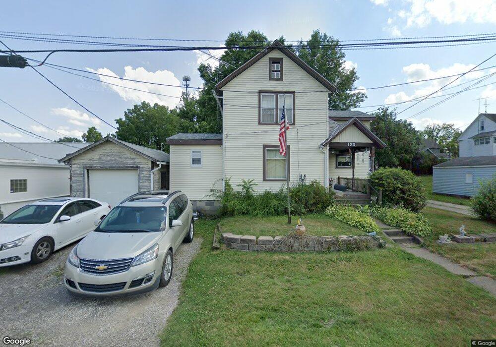
120 W 23rd St Alliance, OH 44601
Estimated Value: $107,000 - $197,000
2
Beds
2
Baths
1,498
Sq Ft
$97/Sq Ft
Est. Value
About This Home
This home is located at 120 W 23rd St, Alliance, OH 44601 and is currently estimated at $145,526, approximately $97 per square foot. 120 W 23rd St is a home located in Stark County with nearby schools including Alliance Elementary School at Rockhill, Alliance Intermediate School at Northside, and Alliance Middle School.
Ownership History
Date
Name
Owned For
Owner Type
Purchase Details
Closed on
Nov 22, 1995
Sold by
Hickman Edgar V
Bought by
Aeling Michael L and Aeling Christine
Current Estimated Value
Home Financials for this Owner
Home Financials are based on the most recent Mortgage that was taken out on this home.
Original Mortgage
$38,250
Outstanding Balance
$533
Interest Rate
7.56%
Mortgage Type
VA
Estimated Equity
$144,993
Purchase Details
Closed on
Aug 31, 1992
Purchase Details
Closed on
Nov 20, 1989
Create a Home Valuation Report for This Property
The Home Valuation Report is an in-depth analysis detailing your home's value as well as a comparison with similar homes in the area
Home Values in the Area
Average Home Value in this Area
Purchase History
| Date | Buyer | Sale Price | Title Company |
|---|---|---|---|
| Aeling Michael L | $37,500 | -- | |
| -- | $20,800 | -- | |
| -- | $20,500 | -- |
Source: Public Records
Mortgage History
| Date | Status | Borrower | Loan Amount |
|---|---|---|---|
| Open | Aeling Michael L | $38,250 |
Source: Public Records
Tax History Compared to Growth
Tax History
| Year | Tax Paid | Tax Assessment Tax Assessment Total Assessment is a certain percentage of the fair market value that is determined by local assessors to be the total taxable value of land and additions on the property. | Land | Improvement |
|---|---|---|---|---|
| 2025 | -- | $32,310 | $6,620 | $25,690 |
| 2024 | -- | $32,310 | $6,620 | $25,690 |
| 2023 | $684 | $26,190 | $8,370 | $17,820 |
| 2022 | $706 | $26,190 | $8,370 | $17,820 |
| 2021 | $706 | $26,190 | $8,370 | $17,820 |
| 2020 | $638 | $23,460 | $7,250 | $16,210 |
| 2019 | $629 | $23,460 | $7,250 | $16,210 |
| 2018 | $632 | $23,460 | $7,250 | $16,210 |
| 2017 | $502 | $20,240 | $6,090 | $14,150 |
| 2016 | $490 | $19,890 | $6,090 | $13,800 |
| 2015 | $494 | $19,890 | $6,090 | $13,800 |
| 2014 | $350 | $16,250 | $4,970 | $11,280 |
| 2013 | $174 | $16,250 | $4,970 | $11,280 |
Source: Public Records
Map
Nearby Homes
- 317 E State St
- 236 E Milton St
- 2460 S Arch Ave
- 112 E College St
- 2408 S Linden Ave
- 2218 S Freedom Ave
- 390 E College St
- 1846 S Freedom Ave
- 2376 S Seneca Ave
- 1475 Chatauqua Ct
- 2839 S Rockhill Ave
- 884 W College Rd
- 555 E Milton St
- 1515 S Rockhill Ave
- 1437 S Linden Ave
- 3101 Ridgehill Ave
- 853 Fairway Dr
- 1059 Oakwood Dr
- 815 Grace St
- 729 Waugh St
- 2324 Miller Ave
- 2324 Miller Ave
- 2306 Miller Ave
- 2328 1/2 Miller Ave
- 2328 Miller Ave
- 2328 Miller Ave
- 2330 Miller Ave
- 131 W 23rd St
- 121 W 23rd St
- 2248 Miller Ave
- 2334 Miller Ave
- 109 W 23rd St
- 2234 Miller Ave
- 2406 Miller Ave
- 2364 Miller Ave
- 2315 Miller Ave
- 2305 Miller Ave
- 2325 Miller Ave
- 2337 S Union Ave
- 2220 Miller Ave