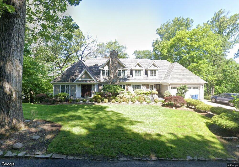
120 Winchip Rd Summit, NJ 07901
Estimated Value: $2,265,000 - $3,194,000
Studio
--
Bath
4,917
Sq Ft
$527/Sq Ft
Est. Value
About This Home
This home is located at 120 Winchip Rd, Summit, NJ 07901 and is currently estimated at $2,590,231, approximately $526 per square foot. 120 Winchip Rd is a home located in Union County with nearby schools including Columbia Middle School, Governor Livingston High School, and The Academy of Our Lady of Peace.
Ownership History
Date
Name
Owned For
Owner Type
Purchase Details
Closed on
Apr 16, 2010
Sold by
Zecca Andrew and Zecca Stephanie
Bought by
Dolan James and Dolan Stephanie
Current Estimated Value
Home Financials for this Owner
Home Financials are based on the most recent Mortgage that was taken out on this home.
Original Mortgage
$400,000
Interest Rate
4.38%
Mortgage Type
New Conventional
Purchase Details
Closed on
Feb 23, 2004
Sold by
Pfaltz Hugo
Bought by
Zecca Andrew and Zecca Stephanie
Home Financials for this Owner
Home Financials are based on the most recent Mortgage that was taken out on this home.
Original Mortgage
$414,000
Interest Rate
5.65%
Create a Home Valuation Report for This Property
The Home Valuation Report is an in-depth analysis detailing your home's value as well as a comparison with similar homes in the area
Home Values in the Area
Average Home Value in this Area
Purchase History
| Date | Buyer | Sale Price | Title Company |
|---|---|---|---|
| Dolan James | $1,425,000 | None Available | |
| Zecca Andrew | $460,000 | -- |
Source: Public Records
Mortgage History
| Date | Status | Borrower | Loan Amount |
|---|---|---|---|
| Closed | Dolan James | $400,000 | |
| Previous Owner | Zecca Andrew | $414,000 |
Source: Public Records
Tax History
| Year | Tax Paid | Tax Assessment Tax Assessment Total Assessment is a certain percentage of the fair market value that is determined by local assessors to be the total taxable value of land and additions on the property. | Land | Improvement |
|---|---|---|---|---|
| 2025 | $28,946 | $675,200 | $303,000 | $372,200 |
| 2024 | $28,527 | $675,200 | $303,000 | $372,200 |
| 2023 | $28,527 | $675,200 | $303,000 | $372,200 |
| 2022 | $28,352 | $675,200 | $303,000 | $372,200 |
| 2021 | $28,196 | $675,200 | $303,000 | $372,200 |
| 2020 | $28,345 | $675,200 | $303,000 | $372,200 |
| 2019 | $28,203 | $675,200 | $303,000 | $372,200 |
| 2018 | $27,616 | $675,200 | $303,000 | $372,200 |
| 2017 | $27,133 | $671,600 | $303,000 | $368,600 |
| 2016 | $26,656 | $671,600 | $303,000 | $368,600 |
| 2015 | $26,508 | $671,600 | $303,000 | $368,600 |
| 2014 | $25,816 | $671,600 | $303,000 | $368,600 |
Source: Public Records
Map
Nearby Homes
- 71 Dale Dr
- 113 Crest Dr
- 65 Seven Oaks Dr
- 63 Gallinson Dr
- 78 Seven Oaks Dr
- 39 Gallinson Dr
- 49 the Fellsway
- 61 Oakwood Dr
- 15 Alison Ct
- 22 Brook Hollow Ln
- 157 Grant Ave
- 11 Dorr Rd
- 27 Hunterdon Blvd
- 27 Grant Ave
- 199 Hickson Dr
- 226 Mountain Ave
- 65 Division Ave
- 491 Central Ave Unit 3
- 491 Central Ave Unit 2
- 491 Central Ave Unit 1
Your Personal Tour Guide
Ask me questions while you tour the home.