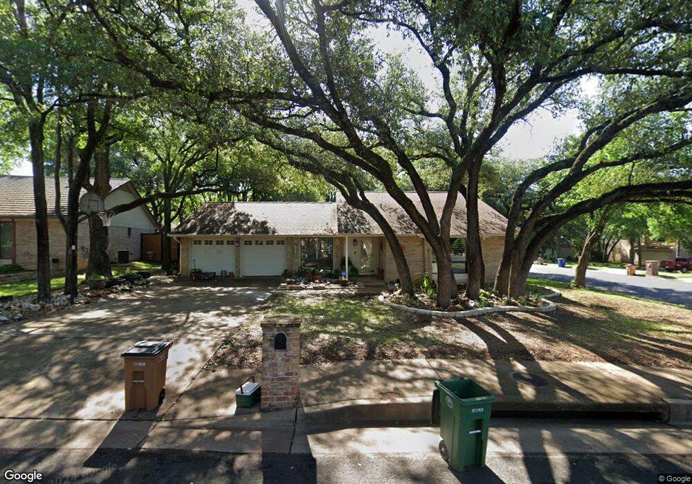
12001 Carmel Park Ln Austin, TX 78727
Milwood NeighborhoodEstimated Value: $481,794 - $585,000
--
Bed
2
Baths
1,872
Sq Ft
$281/Sq Ft
Est. Value
About This Home
This home is located at 12001 Carmel Park Ln, Austin, TX 78727 and is currently estimated at $525,449, approximately $280 per square foot. 12001 Carmel Park Ln is a home located in Travis County with nearby schools including Summitt Elementary School, Murchison Middle School, and Anderson High School.
Ownership History
Date
Name
Owned For
Owner Type
Purchase Details
Closed on
Apr 3, 2013
Sold by
Scheske Robert B and Scheske Teddy Jo
Bought by
Scheske Teddy Jo and Ellis Teddy Jo
Current Estimated Value
Purchase Details
Closed on
Jul 19, 2011
Sold by
Scheske Teddy Jo and Ellis Teddy Jo
Bought by
Scheske Robert B
Purchase Details
Closed on
Sep 27, 2005
Sold by
Eli John D
Bought by
Ellis Teddy Jo
Purchase Details
Closed on
Feb 20, 1998
Sold by
Ellis Michael Thomas
Bought by
Ellis Teddy Jo
Home Financials for this Owner
Home Financials are based on the most recent Mortgage that was taken out on this home.
Original Mortgage
$64,615
Interest Rate
6.92%
Mortgage Type
Seller Take Back
Create a Home Valuation Report for This Property
The Home Valuation Report is an in-depth analysis detailing your home's value as well as a comparison with similar homes in the area
Home Values in the Area
Average Home Value in this Area
Purchase History
| Date | Buyer | Sale Price | Title Company |
|---|---|---|---|
| Scheske Teddy Jo | -- | None Available | |
| Scheske Robert B | -- | None Available | |
| Ellis Teddy Jo | -- | -- | |
| Ellis Teddy Jo | -- | -- |
Source: Public Records
Mortgage History
| Date | Status | Borrower | Loan Amount |
|---|---|---|---|
| Previous Owner | Ellis Teddy Jo | $64,615 |
Source: Public Records
Tax History Compared to Growth
Tax History
| Year | Tax Paid | Tax Assessment Tax Assessment Total Assessment is a certain percentage of the fair market value that is determined by local assessors to be the total taxable value of land and additions on the property. | Land | Improvement |
|---|---|---|---|---|
| 2025 | $2,369 | $457,422 | $273,397 | $184,025 |
| 2023 | $2,369 | $507,353 | $0 | $0 |
| 2022 | $9,109 | $461,230 | $0 | $0 |
| 2021 | $9,127 | $419,300 | $180,000 | $239,300 |
| 2020 | $8,305 | $387,200 | $180,000 | $207,200 |
| 2018 | $7,286 | $329,112 | $180,000 | $154,216 |
| 2017 | $6,672 | $299,193 | $120,000 | $196,370 |
| 2016 | $6,066 | $271,994 | $100,000 | $181,866 |
| 2015 | $2,833 | $247,267 | $60,000 | $199,549 |
| 2014 | $2,833 | $224,788 | $60,000 | $164,788 |
Source: Public Records
Map
Nearby Homes
- 4400 Switch Willo Unit 21
- 12103 Wycliff Ln
- 4006 Eton Ln
- 3901 Skipton Dr
- 4508 Duval Rd Unit 6602
- 12203 Arrowwood Dr
- 11718 Running Fox Trail
- 11716 Running Fox Trail
- 12223 Antoinette Place
- 12319 Wycliff Ln
- 4503 Beaver Creek Dr
- 4606 Gray Fox Dr
- 4605 Beaver Creek Dr
- 4812 Pelham Dr
- 5001 Dull Knife Dr
- 12302 Havelock Dr
- 11602 Santa Cruz Dr
- 12404 Sceptre Cove
- 12208 Forsythe Dr
- 12005 Mustang Chase
- 12003 Carmel Park Ln
- 12000 Fremont Cove
- 12002 Fremont Cove
- 12000 Carmel Park Ln
- 11968 Dorsett Rd
- 12005 Carmel Park Ln
- 12002 Carmel Park Ln
- 12004 Fremont Cove
- 11970 Dorsett Rd
- 11966 Dorsett Rd
- 11964 Dorsett Rd
- 11972 Dorsett Rd
- 11962 Dorsett Rd
- 12006 Fremont Cove
- 12007 Carmel Park Ln
- 11960 Dorsett Rd
- 11974 Dorsett Rd
- 12004 Carmel Park Ln
- 12001 Fremont Cove
- 11958 Dorsett Rd