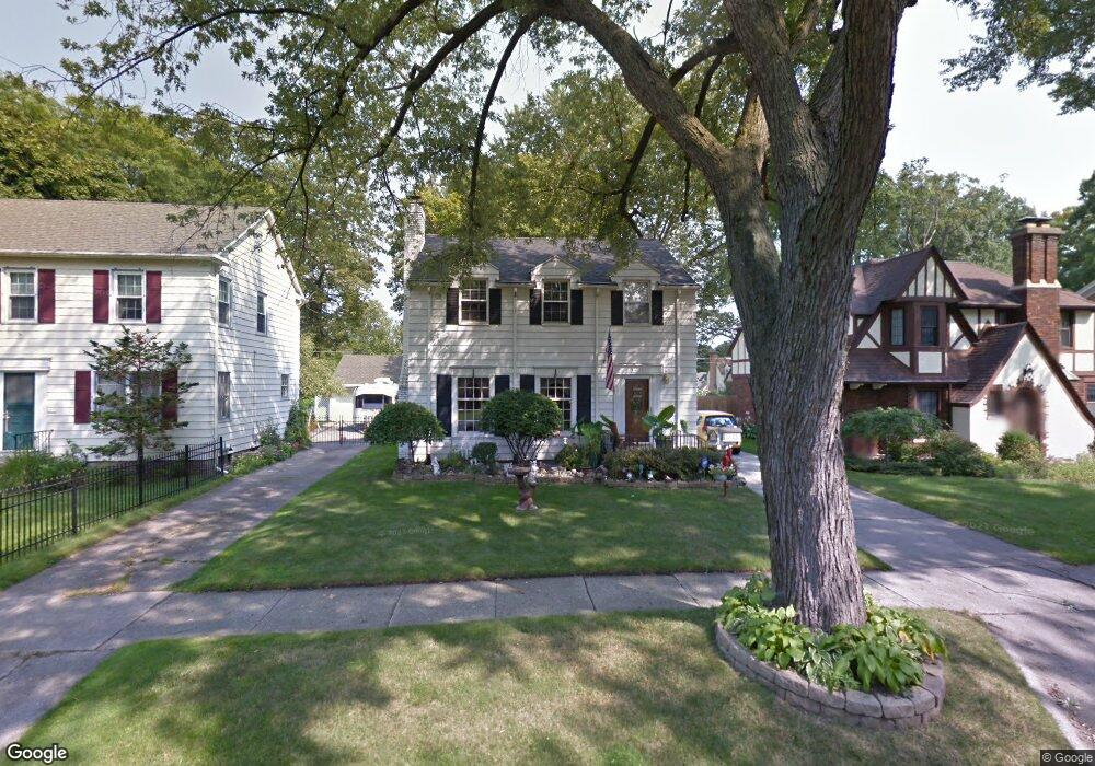
1201 Blanchard Ave Flint, MI 48503
College Cultural Neighborhood NeighborhoodEstimated Value: $157,418 - $205,000
Studio
2
Baths
1,615
Sq Ft
$113/Sq Ft
Est. Value
About This Home
This home is located at 1201 Blanchard Ave, Flint, MI 48503 and is currently estimated at $182,605, approximately $113 per square foot. 1201 Blanchard Ave is a home located in Genesee County with nearby schools including Pierce Elementary School, Flint Southwestern Classical Academy, and Flint Cultural Center Academy.
Ownership History
Date
Name
Owned For
Owner Type
Purchase Details
Closed on
Dec 14, 2007
Sold by
Marie J Taylor Living Trust
Bought by
Deming Carl E and Deming Lucinda L
Current Estimated Value
Home Financials for this Owner
Home Financials are based on the most recent Mortgage that was taken out on this home.
Original Mortgage
$118,044
Outstanding Balance
$73,392
Interest Rate
6.31%
Mortgage Type
FHA
Estimated Equity
$109,213
Purchase Details
Closed on
Jul 30, 2001
Sold by
Taylor Marie J and Taylor Burt W
Bought by
Taylor Marie J and Marie J Taylor Living Trust
Create a Home Valuation Report for This Property
The Home Valuation Report is an in-depth analysis detailing your home's value as well as a comparison with similar homes in the area
Home Values in the Area
Average Home Value in this Area
Purchase History
| Date | Buyer | Sale Price | Title Company |
|---|---|---|---|
| Deming Carl E | $119,000 | Cislo Title Co | |
| Taylor Marie J | -- | None Available |
Source: Public Records
Mortgage History
| Date | Status | Borrower | Loan Amount |
|---|---|---|---|
| Open | Deming Carl E | $118,044 |
Source: Public Records
Tax History
| Year | Tax Paid | Tax Assessment Tax Assessment Total Assessment is a certain percentage of the fair market value that is determined by local assessors to be the total taxable value of land and additions on the property. | Land | Improvement |
|---|---|---|---|---|
| 2025 | $1,593 | $71,200 | $0 | $0 |
| 2024 | $1,422 | $68,200 | $0 | $0 |
| 2023 | $1,385 | $56,400 | $0 | $0 |
| 2022 | $0 | $47,400 | $0 | $0 |
| 2021 | $1,453 | $45,000 | $0 | $0 |
| 2020 | $1,289 | $42,500 | $0 | $0 |
| 2019 | $1,243 | $38,200 | $0 | $0 |
| 2018 | $1,289 | $29,600 | $0 | $0 |
| 2017 | $1,248 | $0 | $0 | $0 |
| 2016 | $1,239 | $0 | $0 | $0 |
| 2015 | -- | $0 | $0 | $0 |
| 2014 | -- | $0 | $0 | $0 |
| 2012 | -- | $27,200 | $0 | $0 |
Source: Public Records
Map
Nearby Homes
- 1210 Blanchard Ave
- 1510 S Franklin Ave
- 1114 W Vernon Dr
- 2013 E Court St
- 2119 Mountain Ave
- 915 E 8th St
- 915 E Court #206 St Unit 206
- 915 E Court St
- 605 S Lynch St
- 1851 Seymour Ave
- 1701 Park St
- 1720 Park St
- 1814 Mcphail St
- 1840 Mcphail St
- 301 Chandler St
- 434 Chalmers St
- 2010 Crocker Ave
- 2029 Winans Ave
- 710 Pierson St
- 621 Pierson St
- 1205 Blanchard Ave
- 1117 Blanchard Ave
- 1113 Blanchard Ave
- 1209 Blanchard Ave
- 1213 Blanchard Ave
- 1122 Kensington Ave
- 1126 Kensington Ave
- 1118 Kensington Ave
- 1114 Kensington Ave
- 1130 Kensington Ave
- 1110 Blanchard Ave
- 1202 Blanchard Ave
- 1110 Kensington Ave
- 1118 Blanchard Ave
- 1206 Blanchard Ave
- 1105 Blanchard Ave
- 1138 Kensington Ave
- 1106 Kensington Ave
- 1301 Blanchard Ave Unit Bldg-Unit
- 1301 Blanchard Ave
Your Personal Tour Guide
Ask me questions while you tour the home.