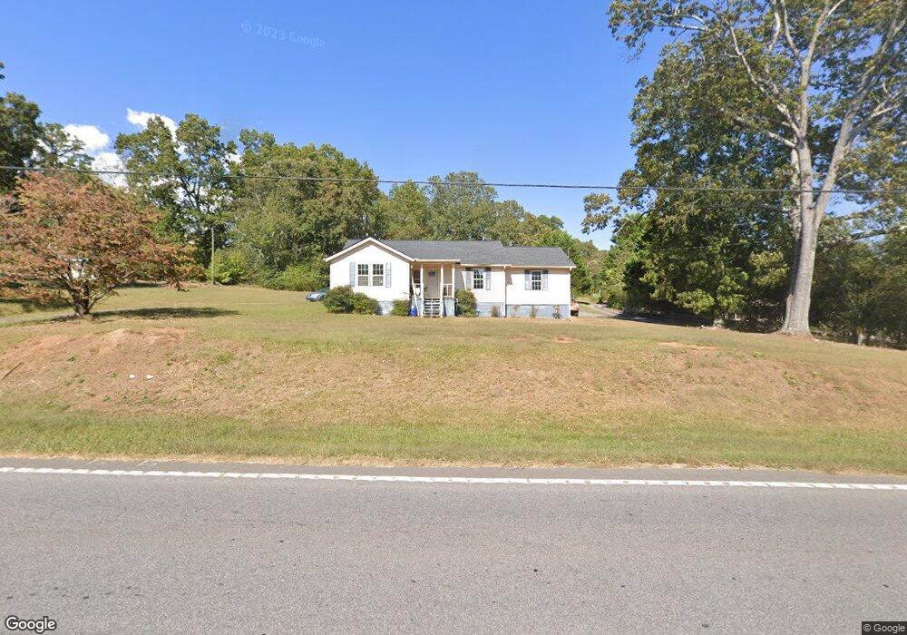
1201 Cannon Bridge Rd Demorest, GA 30535
Estimated Value: $266,000 - $340,012
4
Beds
2
Baths
1,800
Sq Ft
$162/Sq Ft
Est. Value
About This Home
This home is located at 1201 Cannon Bridge Rd, Demorest, GA 30535 and is currently estimated at $292,253, approximately $162 per square foot. 1201 Cannon Bridge Rd is a home located in Habersham County with nearby schools including Fairview Elementary School, South Habersham Middle School, and Habersham Success Academy.
Ownership History
Date
Name
Owned For
Owner Type
Purchase Details
Closed on
Apr 29, 2019
Sold by
Morgan Joe E
Bought by
Blasberg Rachel Lindsey
Current Estimated Value
Home Financials for this Owner
Home Financials are based on the most recent Mortgage that was taken out on this home.
Original Mortgage
$36,000
Interest Rate
4%
Mortgage Type
New Conventional
Purchase Details
Closed on
Feb 6, 2018
Sold by
Larsen Paula
Bought by
Morgan Joe
Purchase Details
Closed on
Mar 14, 2017
Sold by
Morgan Joe E
Bought by
Larsen Paula A
Create a Home Valuation Report for This Property
The Home Valuation Report is an in-depth analysis detailing your home's value as well as a comparison with similar homes in the area
Home Values in the Area
Average Home Value in this Area
Purchase History
| Date | Buyer | Sale Price | Title Company |
|---|---|---|---|
| Blasberg Rachel Lindsey | $46,000 | -- | |
| Morgan Joe | $102,520 | -- | |
| Larsen Paula A | -- | -- |
Source: Public Records
Mortgage History
| Date | Status | Borrower | Loan Amount |
|---|---|---|---|
| Closed | Blasberg Rachel Lindsey | $36,000 |
Source: Public Records
Tax History
| Year | Tax Paid | Tax Assessment Tax Assessment Total Assessment is a certain percentage of the fair market value that is determined by local assessors to be the total taxable value of land and additions on the property. | Land | Improvement |
|---|---|---|---|---|
| 2025 | $1,644 | $93,217 | $15,809 | $77,408 |
| 2024 | -- | $81,688 | $8,744 | $72,944 |
| 2023 | $962 | $69,760 | $8,744 | $61,016 |
| 2022 | $1,349 | $61,388 | $8,744 | $52,644 |
| 2021 | $1,249 | $53,060 | $5,464 | $47,596 |
| 2020 | $902 | $35,448 | $5,464 | $29,984 |
| 2019 | $546 | $46,988 | $5,464 | $41,524 |
| 2018 | $1,187 | $44,444 | $5,464 | $38,980 |
| 2017 | $1,101 | $41,008 | $4,372 | $36,636 |
| 2016 | $409 | $102,520 | $4,372 | $36,636 |
| 2015 | $396 | $102,410 | $4,328 | $36,636 |
| 2014 | $394 | $100,610 | $4,328 | $35,916 |
| 2013 | -- | $40,244 | $4,328 | $35,916 |
Source: Public Records
Map
Nearby Homes
- 308 Parthenia Dr
- 3750 Old Cleveland Rd
- 277 Stonebrook Dr
- 180 Springbrook Dr
- 114 Springbrook Dr
- 451 Spiral Hills Dr
- 660 Bald Ridge Cir
- 668 Bald Ridge Cir
- 515 Wauka Dr
- 539 Wauka Dr
- 545 Wauka Dr
- 159 Hardyville Cir
- 8.5 +/- Smith Loop
- 226 Chestnut Ave
- 241 Huntington Manor Ct
- 155 Brentwood Dr
- 107 Brasstown Ln
- 716 Westcrest Ln
- 264 Canyon Point Dr
- 256 Canyon Point Dr
- 1219 Cannon Bridge Rd
- 1135 Cannon Bridge Rd
- 1322 Cannon Bridge Rd
- 1322 Cannon Bridge Rd
- 152 Coldwater Dr
- 160 Cold Water Dr
- 1250 Cannon Bridge Rd
- 1293 Cannon Bridge Rd
- 107 Cannon Lily Cir
- 1370 Cannon Bridge Rd
- 152 Cold Water Dr
- 250 Christy Way
- 207 Christy Way
- 1129 Cannon Bridge Rd
- 1410 Cannon Bridge Rd
- 278 Christy Way
- 171 Cannon Lily Cir
- 175 Cannon Lily Cir
- 110 Squirrel Trail
- 105 Squirrel Trail
Your Personal Tour Guide
Ask me questions while you tour the home.