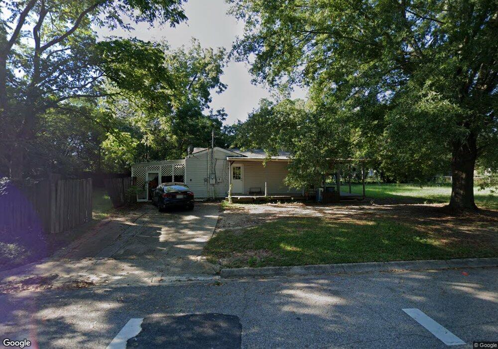
1201 Cannon Dr Dothan, AL 36301
Estimated Value: $94,000 - $111,000
2
Beds
1
Bath
1,152
Sq Ft
$91/Sq Ft
Est. Value
About This Home
This home is located at 1201 Cannon Dr, Dothan, AL 36301 and is currently estimated at $104,524, approximately $90 per square foot. 1201 Cannon Dr is a home located in Houston County with nearby schools including Dothan City Early Education Center, Beverlye Intermediate School, and Hidden Lake Elementary School.
Ownership History
Date
Name
Owned For
Owner Type
Purchase Details
Closed on
Nov 29, 2011
Sold by
Sunsouth Bank
Bought by
Mason Holdings Llc
Current Estimated Value
Home Financials for this Owner
Home Financials are based on the most recent Mortgage that was taken out on this home.
Original Mortgage
$30,000
Outstanding Balance
$20,436
Interest Rate
4.15%
Mortgage Type
Future Advance Clause Open End Mortgage
Estimated Equity
$84,088
Purchase Details
Closed on
Dec 14, 2010
Sold by
Flores Miguel A
Bought by
Sunsouth Bank
Create a Home Valuation Report for This Property
The Home Valuation Report is an in-depth analysis detailing your home's value as well as a comparison with similar homes in the area
Purchase History
| Date | Buyer | Sale Price | Title Company |
|---|---|---|---|
| Mason Holdings Llc | $18,000 | -- | |
| Sunsouth Bank | -- | -- |
Source: Public Records
Mortgage History
| Date | Status | Borrower | Loan Amount |
|---|---|---|---|
| Open | Sunsouth Bank | $30,000 |
Source: Public Records
Tax History
| Year | Tax Paid | Tax Assessment Tax Assessment Total Assessment is a certain percentage of the fair market value that is determined by local assessors to be the total taxable value of land and additions on the property. | Land | Improvement |
|---|---|---|---|---|
| 2025 | $596 | $16,560 | $0 | $0 |
| 2024 | $596 | $15,800 | $0 | $0 |
| 2023 | $569 | $13,660 | $0 | $0 |
| 2022 | $404 | $11,720 | $0 | $0 |
| 2021 | $315 | $13,280 | $0 | $0 |
| 2020 | $321 | $9,300 | $0 | $0 |
| 2019 | $342 | $9,580 | $0 | $0 |
| 2018 | $321 | $9,300 | $0 | $0 |
| 2017 | $314 | $9,100 | $0 | $0 |
| 2016 | $296 | $0 | $0 | $0 |
| 2015 | $296 | $0 | $0 | $0 |
| 2014 | $374 | $0 | $0 | $0 |
Source: Public Records
Map
Nearby Homes
- 1208 Jonathan St
- 1304 Jonathan St
- 211 Cumberland Dr
- 113 Cumberland Dr
- 408 Darlington Cir
- 1657 Third Ave
- 1437 E Selma St
- 209 Pearl St
- 901 Haven Dr
- 610 Pinto Dr
- 0 Maverick Dr
- 116 Radford Cir
- 808 Dutch St
- 305 Cyclone Cir
- 2103 Berryhill Dr
- 2316 Wilkins St
- 1447 Coe Dairy Rd
- 502 Vassar St
- 300 Reid Dr
- 207 Candace Ct
- 1203 Cannon Dr
- 1200 Bradley Rd
- 1205 Cannon Dr
- 612 Mustang Dr
- 610 Mustang Dr
- 1200 Cannon Dr
- 1202 Cannon Dr
- 1204 Bradley Rd
- 513 Explorer Cir
- 1207 Cannon Dr
- 1204 Cannon Dr
- 611 Mustang Dr
- 512 Explorer Cir
- 1206 Bradley Rd
- 1206 Cannon Dr
- 608 Mustang Dr
- 1209 Cannon Dr
- 1201 Travis Rd
- 1201 Bradley Rd
- 1203 Travis Rd
Your Personal Tour Guide
Ask me questions while you tour the home.