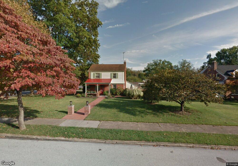
1201 Dorothy Ave Phoenixville, PA 19460
Estimated Value: $495,543 - $660,000
3
Beds
1
Bath
1,598
Sq Ft
$349/Sq Ft
Est. Value
About This Home
This home is located at 1201 Dorothy Ave, Phoenixville, PA 19460 and is currently estimated at $557,636, approximately $348 per square foot. 1201 Dorothy Ave is a home located in Chester County with nearby schools including Schuylkill Elementary School, Phoenixville Area Middle School, and Phoenixville Area High School.
Ownership History
Date
Name
Owned For
Owner Type
Purchase Details
Closed on
Mar 14, 2008
Sold by
Hynson Benjamin T
Bought by
Hynson Benjamin T and Hynson Lorraine E
Current Estimated Value
Purchase Details
Closed on
Oct 24, 2003
Sold by
Serhienko Linda Jane and Moyer Randee E
Bought by
Hynson Benjamin T
Home Financials for this Owner
Home Financials are based on the most recent Mortgage that was taken out on this home.
Original Mortgage
$185,000
Interest Rate
5.96%
Mortgage Type
Purchase Money Mortgage
Create a Home Valuation Report for This Property
The Home Valuation Report is an in-depth analysis detailing your home's value as well as a comparison with similar homes in the area
Home Values in the Area
Average Home Value in this Area
Purchase History
| Date | Buyer | Sale Price | Title Company |
|---|---|---|---|
| Hynson Benjamin T | -- | None Available | |
| Hynson Benjamin T | $235,000 | -- |
Source: Public Records
Mortgage History
| Date | Status | Borrower | Loan Amount |
|---|---|---|---|
| Previous Owner | Hynson Benjamin T | $185,000 | |
| Closed | Hynson Benjamin T | $26,000 |
Source: Public Records
Tax History Compared to Growth
Tax History
| Year | Tax Paid | Tax Assessment Tax Assessment Total Assessment is a certain percentage of the fair market value that is determined by local assessors to be the total taxable value of land and additions on the property. | Land | Improvement |
|---|---|---|---|---|
| 2025 | $7,033 | $153,230 | $55,710 | $97,520 |
| 2024 | $7,033 | $153,230 | $55,710 | $97,520 |
| 2023 | $6,877 | $153,230 | $55,710 | $97,520 |
| 2022 | $6,773 | $153,230 | $55,710 | $97,520 |
| 2021 | $6,676 | $153,230 | $55,710 | $97,520 |
| 2020 | $6,405 | $153,230 | $55,710 | $97,520 |
| 2019 | $6,287 | $153,230 | $55,710 | $97,520 |
| 2018 | $6,108 | $153,230 | $55,710 | $97,520 |
| 2017 | $6,014 | $153,230 | $55,710 | $97,520 |
| 2016 | $570 | $153,230 | $55,710 | $97,520 |
| 2015 | $570 | $153,230 | $55,710 | $97,520 |
| 2014 | $570 | $153,230 | $55,710 | $97,520 |
Source: Public Records
Map
Nearby Homes
- 41 Terrace Dr
- 13 2nd St
- 760 Starr St
- 415 Virginia Ave
- 519 W Anderson Ave
- 99 Starr St
- 308 Locust Dr
- 139 Rossiter Ave
- 200 Lincoln Ave Unit 311
- 345 Hall St
- 228 Church St
- 1005 Cherry St
- 32 Gay St
- 365 Church St
- 134 Bridge St Unit 201
- 4104 Tinker Hill Rd
- 429 Smithworks Blvd
- 431 Smithworks Blvd
- 637 Burcham St
- 433 Smithworks Blvd
- 1209 Dorothy Ave
- 13 Anderson Ave
- 1210 Natalie Rd
- 1215 Dorothy Ave
- 8 Anderson Ave
- 1200 Dorothy Ave
- 7 Anderson Ave
- 11 Anderson Ave
- 1210 Dorothy Ave
- 6 Anderson Ave
- 12 Anderson Ave
- 1219 Dorothy Ave
- 1214 Dorothy Ave
- 1220 Natalie Rd
- 5 Anderson Ave
- 14 Anderson Ave
- 1220 Dorothy Ave
- 15 Anderson Ave
- 1207 Natalie Rd
- 2 Melvin Rd