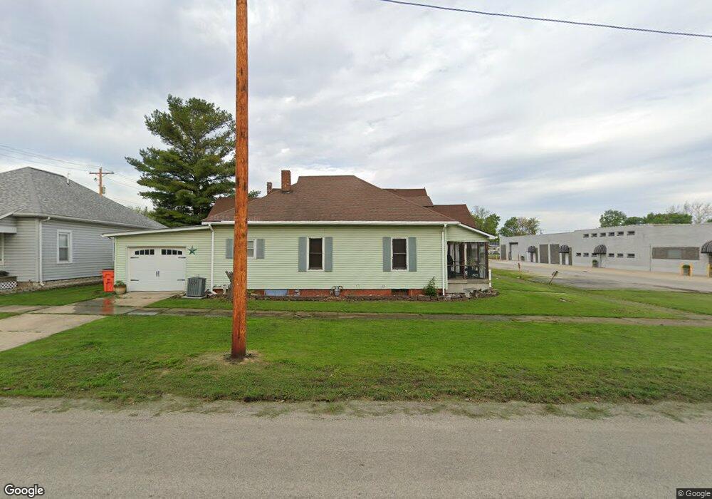
1201 Moultrie Ave Mattoon, IL 61938
Estimated Value: $60,074 - $84,000
2
Beds
1
Bath
1,092
Sq Ft
$68/Sq Ft
Est. Value
About This Home
This home is located at 1201 Moultrie Ave, Mattoon, IL 61938 and is currently estimated at $74,269, approximately $68 per square foot. 1201 Moultrie Ave is a home located in Coles County with nearby schools including Mattoon High School, St Mary School, and St. John's Lutheran School.
Ownership History
Date
Name
Owned For
Owner Type
Purchase Details
Closed on
Sep 12, 2007
Sold by
Hillerby Christopher R and Hillerby Beth M
Bought by
Slifer David L and Slifer Virginia M
Current Estimated Value
Home Financials for this Owner
Home Financials are based on the most recent Mortgage that was taken out on this home.
Original Mortgage
$52,250
Outstanding Balance
$33,318
Interest Rate
6.71%
Mortgage Type
New Conventional
Estimated Equity
$40,951
Create a Home Valuation Report for This Property
The Home Valuation Report is an in-depth analysis detailing your home's value as well as a comparison with similar homes in the area
Home Values in the Area
Average Home Value in this Area
Purchase History
| Date | Buyer | Sale Price | Title Company |
|---|---|---|---|
| Slifer David L | $55,000 | None Available |
Source: Public Records
Mortgage History
| Date | Status | Borrower | Loan Amount |
|---|---|---|---|
| Open | Slifer David L | $52,250 |
Source: Public Records
Tax History Compared to Growth
Tax History
| Year | Tax Paid | Tax Assessment Tax Assessment Total Assessment is a certain percentage of the fair market value that is determined by local assessors to be the total taxable value of land and additions on the property. | Land | Improvement |
|---|---|---|---|---|
| 2024 | $1,071 | $18,598 | $765 | $17,833 |
| 2023 | $903 | $16,605 | $683 | $15,922 |
| 2022 | $903 | $16,331 | $672 | $15,659 |
| 2021 | $885 | $15,000 | $617 | $14,383 |
| 2020 | $869 | $15,541 | $639 | $14,902 |
| 2019 | $786 | $14,454 | $2,184 | $12,270 |
| 2018 | $772 | $14,454 | $2,184 | $12,270 |
| 2017 | $769 | $14,454 | $2,184 | $12,270 |
| 2016 | $753 | $14,454 | $2,184 | $12,270 |
| 2015 | $568 | $14,454 | $2,184 | $12,270 |
| 2014 | $568 | $14,454 | $2,184 | $12,270 |
| 2013 | $568 | $14,454 | $2,184 | $12,270 |
Source: Public Records
Map
Nearby Homes
- 1205 Champaign Ave
- 1412 Champaign Ave
- 1 Brown Ct
- 916 Piatt Ave
- 812 N 8th St Unit 36
- 1612 Richmond Ave
- 1705 Dewitt Ave
- 816 Grant Ave
- 812 N 7th St Unit 73
- 909 Broadway Ave
- 1905 Dewitt Ave
- 1904 Dewitt Ave
- 1101 Wabash Ave
- 421 Dewitt Ave
- 1908 Dewitt Ave
- 1001 Wabash Ave
- 1401 N 10th St
- 1301 Lafayette Ave
- 1509 Lafayette Ave
- 2104 Moultrie Ave
- 513 N 12th St
- 520 N 12th St
- 1200 Shelby Ave
- 1206 Shelby Ave
- 1113 Moultrie Ave
- 1208 Moultrie Ave
- 1116 Shelby Ave
- 1109 Moultrie Ave
- 1112 Shelby Ave
- 1112 Moultrie Ave
- 1201 Dewitt Ave
- 1218 Shelby Ave
- 1101 Moultrie Ave
- 1108 Shelby Ave
- 1108 Moultrie Ave
- 1104 Moultrie Ave
- 1104 Shelby Ave
- 1213 Dewitt Ave
- 1121 Dewitt Ave
- 1300 Moultrie Ave