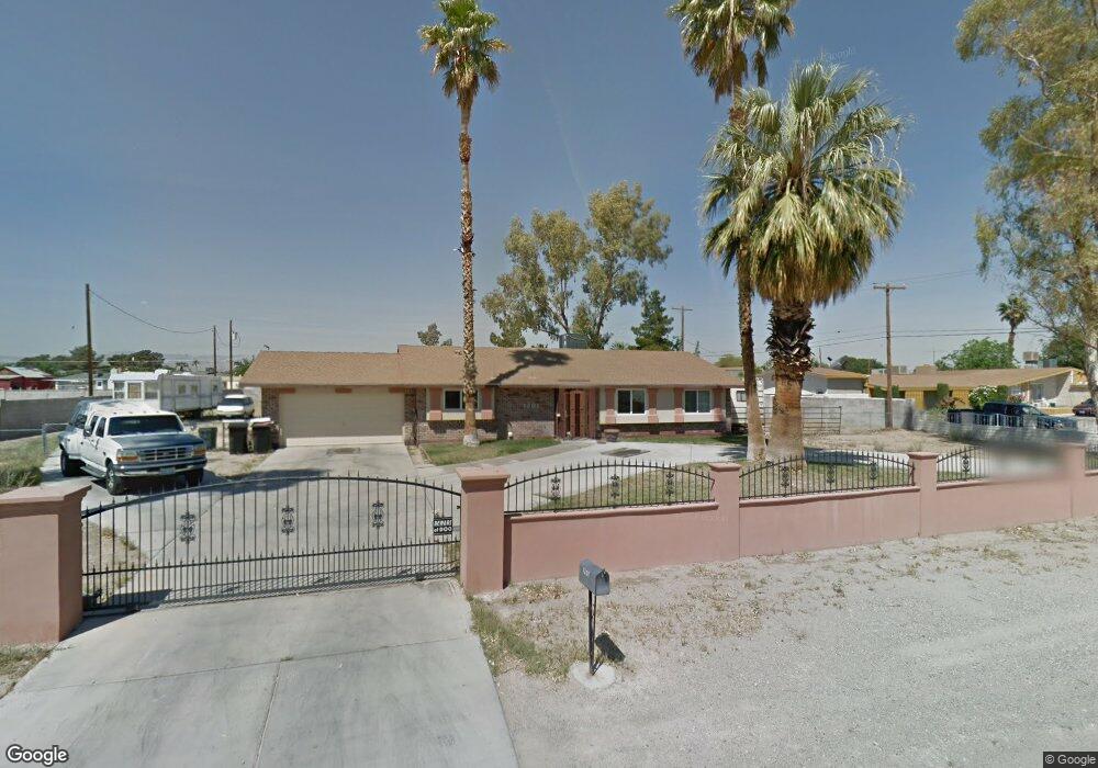
1201 Ralston Dr Las Vegas, NV 89106
West Las Vegas NeighborhoodEstimated Value: $391,000 - $642,000
3
Beds
2
Baths
2,080
Sq Ft
$259/Sq Ft
Est. Value
About This Home
This home is located at 1201 Ralston Dr, Las Vegas, NV 89106 and is currently estimated at $539,125, approximately $259 per square foot. 1201 Ralston Dr is a home located in Clark County with nearby schools including Wendell P. Williams Elementary School, West Prepatory Academy At Charlles I West Hall Sec, and Western High School.
Ownership History
Date
Name
Owned For
Owner Type
Purchase Details
Closed on
Sep 27, 2012
Sold by
Brown Terry Lynn and Brown Ann Miyuki
Bought by
Brown Terry Lynn
Current Estimated Value
Purchase Details
Closed on
Nov 2, 1995
Sold by
Holly Charles
Bought by
Brown Terry Lynn and Brown Ann Miyuki
Home Financials for this Owner
Home Financials are based on the most recent Mortgage that was taken out on this home.
Original Mortgage
$89,500
Interest Rate
7.58%
Purchase Details
Closed on
Aug 9, 1995
Sold by
Walker Lee E and Walker Delores A
Bought by
Holly Charles
Create a Home Valuation Report for This Property
The Home Valuation Report is an in-depth analysis detailing your home's value as well as a comparison with similar homes in the area
Home Values in the Area
Average Home Value in this Area
Purchase History
| Date | Buyer | Sale Price | Title Company |
|---|---|---|---|
| Brown Terry Lynn | -- | None Available | |
| Brown Terry Lynn | $117,500 | Stewart Title | |
| Holly Charles | $80,100 | First American Title Co |
Source: Public Records
Mortgage History
| Date | Status | Borrower | Loan Amount |
|---|---|---|---|
| Previous Owner | Brown Terry Lynn | $89,500 |
Source: Public Records
Tax History Compared to Growth
Tax History
| Year | Tax Paid | Tax Assessment Tax Assessment Total Assessment is a certain percentage of the fair market value that is determined by local assessors to be the total taxable value of land and additions on the property. | Land | Improvement |
|---|---|---|---|---|
| 2025 | $1,747 | $87,553 | $59,500 | $28,053 |
| 2024 | $1,618 | $87,553 | $59,500 | $28,053 |
| 2023 | $1,618 | $84,874 | $59,500 | $25,374 |
| 2022 | $1,498 | $72,004 | $49,350 | $22,654 |
| 2021 | $1,388 | $62,583 | $40,250 | $22,333 |
| 2020 | $1,286 | $56,170 | $33,250 | $22,920 |
| 2019 | $1,205 | $56,547 | $33,250 | $23,297 |
| 2018 | $1,150 | $47,475 | $24,500 | $22,975 |
| 2017 | $1,529 | $46,635 | $22,750 | $23,885 |
| 2016 | $1,077 | $42,573 | $17,500 | $25,073 |
| 2015 | $1,074 | $31,722 | $14,000 | $17,722 |
| 2014 | $1,040 | $35,284 | $10,500 | $24,784 |
Source: Public Records
Map
Nearby Homes
- 1713 Ophir Dr
- 1301 Madison Ave
- 1310 N Tonopah Dr
- 2133 Sleepy Ct
- 1121 W Monroe Ave
- 1101 Leonard Ave
- 2211 Sleepy Ct
- 2045 Rose Coral Ave
- 1641 K St
- 814 W Bonanza Rd
- 1636 J St
- 1018 I St
- 1648 J St
- 1117 Cunningham Dr
- 2400 Dutchmans Pipe Ct
- 211 W Monroe Ave
- 1219 Cunningham Dr
- 1604 Luning Dr
- 2100 Port Ave
- 2520 Bottle Palm Ct
- 1221 Ralston Dr
- 1230 Comstock Dr
- 1200 Comstock Dr
- 1200 Ralston Dr
- 1301 Ralston Dr
- 1131 Ralston Dr
- 1140 Ralston Dr
- 1220 Ralston Dr
- 1300 Comstock Dr
- 1134 Comstock Dr
- 1136 Ralston Dr
- 1300 Ralston Dr
- 1311 Ralston Dr
- 1123 Ralston Dr
- 1306 Comstock Dr
- 1124 Comstock Dr
- 1135 Comstock Dr
- 1233 Comstock Dr
- 1221 Sharon Rd
- 1130 Ralston Dr