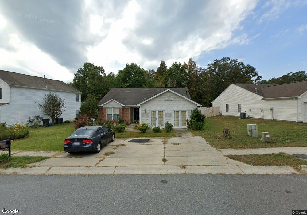
1201 Shenandoah Cir Rock Hill, SC 29730
Estimated Value: $252,445 - $337,000
--
Bed
--
Bath
1,612
Sq Ft
$184/Sq Ft
Est. Value
About This Home
This home is located at 1201 Shenandoah Cir, Rock Hill, SC 29730 and is currently estimated at $296,111, approximately $183 per square foot. 1201 Shenandoah Cir is a home located in York County with nearby schools including Mount Holly Elementary School, Saluda Trail Middle School, and South Pointe High School.
Ownership History
Date
Name
Owned For
Owner Type
Purchase Details
Closed on
Dec 1, 2008
Sold by
Westport Homes Of North Carolina Inc
Bought by
Liles Angela Thompson
Current Estimated Value
Home Financials for this Owner
Home Financials are based on the most recent Mortgage that was taken out on this home.
Original Mortgage
$97,680
Outstanding Balance
$65,325
Interest Rate
6.38%
Mortgage Type
FHA
Estimated Equity
$230,786
Purchase Details
Closed on
Oct 29, 2004
Sold by
Crossmann Communities Of Nc Inc
Bought by
Westport Homes Of North Carolina Inc
Create a Home Valuation Report for This Property
The Home Valuation Report is an in-depth analysis detailing your home's value as well as a comparison with similar homes in the area
Home Values in the Area
Average Home Value in this Area
Purchase History
| Date | Buyer | Sale Price | Title Company |
|---|---|---|---|
| Liles Angela Thompson | $120,000 | -- | |
| Westport Homes Of North Carolina Inc | $115,600 | -- |
Source: Public Records
Mortgage History
| Date | Status | Borrower | Loan Amount |
|---|---|---|---|
| Open | Liles Angela Thompson | $97,680 |
Source: Public Records
Tax History Compared to Growth
Tax History
| Year | Tax Paid | Tax Assessment Tax Assessment Total Assessment is a certain percentage of the fair market value that is determined by local assessors to be the total taxable value of land and additions on the property. | Land | Improvement |
|---|---|---|---|---|
| 2024 | $984 | $4,485 | $970 | $3,515 |
| 2023 | $987 | $4,485 | $969 | $3,516 |
| 2022 | $993 | $4,485 | $969 | $3,516 |
| 2021 | -- | $4,485 | $969 | $3,516 |
| 2020 | $996 | $4,485 | $0 | $0 |
| 2019 | $893 | $3,900 | $0 | $0 |
| 2018 | $892 | $3,900 | $0 | $0 |
| 2017 | $859 | $3,900 | $0 | $0 |
| 2016 | $851 | $3,900 | $0 | $0 |
| 2014 | $953 | $3,900 | $960 | $2,940 |
| 2013 | $953 | $4,580 | $1,120 | $3,460 |
Source: Public Records
Map
Nearby Homes
- 1209 Shenandoah Cir
- 1212 Shenandoah Cir
- 1361 Mount Holly Rd
- 1456 Hyacinthia Ln
- 421 Lakeside Dr
- 446 Eden Oaks Dr
- 1104 Parkmont Ln
- 1634 Dawson Ct
- 263 Fairway Cir
- 288 Fairway Cir
- 1631 Amanda Ln
- 306 Red Fox Trail
- 172 Fairway Cir
- 805 Brunswick Dr
- 846 Mallory Dr
- 264 Abigail Ct
- 753 Schuyler Dr
- 831 Yale St Unit 30
- 914 Bunker Trace
- 922 Bunker Trace
- 1195 Shenandoah Cir
- 1217 Shenandoah Cir
- 1187 Shenandoah Cir
- 1194 Shenandoah Cir
- 1204 Shenandoah Cir
- 1190 Shenandoah Cir
- 1225 Shenandoah Cir
- 1208 Shenandoah Cir
- 1181 Shenandoah Cir
- 1186 Shenandoah Cir
- 1229 Shenandoah Cir
- 1177 Shenandoah Cir
- 1216 Shenandoah Cir
- 1182 Shenandoah Cir
- 1233 Shenandoah Cir
- 1220 Shenandoah Cir
- 1173 Shenandoah Cir
- 1178 Shenandoah Cir
- 1224 Shenandoah Cir
- 1228 Shenandoah Cir