1201 Whitesville St Lagrange, GA 30240
Estimated payment $9,312/month
About This Lot
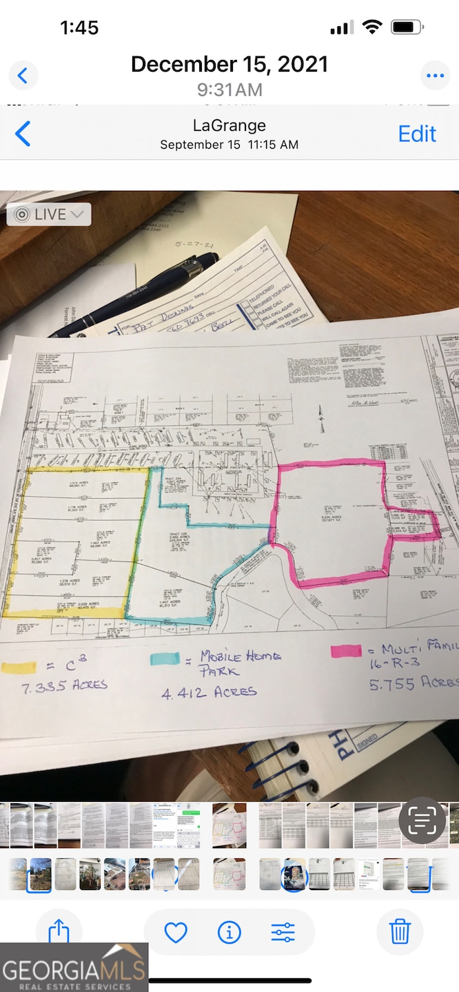
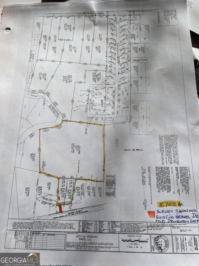
Investors Dream 6acres zone multi family with approved 60 units apartments 4.4 acres Zone Mobile Home park 7acres zoned commercial Double road frontage
Listing Agent
Stribling-Dupree Rlty & Appraisal License #107082 Listed on: 11/18/2025
Property Details
Property Type
- Land
Est. Annual Taxes
- $1,055
Lot Details
- 18 Acre Lot
- Property fronts a highway
Location
- City Lot
Schools
- Clearview Elementary School
- Gardner Newman Middle School
- Lagrange High School
Utilities
- High Speed Internet
- Phone Available
- Cable TV Available
Community Details
- No Home Owners Association
- Mallory Subdivision
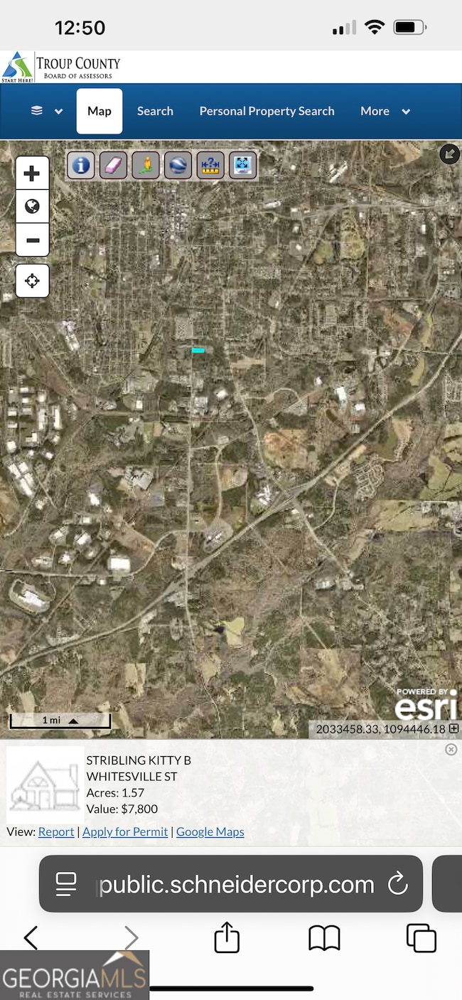
Map
Home Values in the Area
Average Home Value in this Area
Tax History
| Year | Tax Paid | Tax Assessment Tax Assessment Total Assessment is a certain percentage of the fair market value that is determined by local assessors to be the total taxable value of land and additions on the property. | Land | Improvement |
|---|---|---|---|---|
| 2024 | $63 | $2,320 | $2,320 | $0 |
| 2023 | $63 | $2,320 | $2,320 | $0 |
| 2022 | $65 | $2,320 | $2,320 | $0 |
| 2021 | $70 | $2,320 | $2,320 | $0 |
| 2020 | $70 | $2,320 | $2,320 | $0 |
| 2019 | $70 | $2,320 | $2,320 | $0 |
| 2018 | $70 | $2,320 | $2,320 | $0 |
| 2017 | $58 | $3,480 | $3,480 | $0 |
| 2016 | $151 | $5,015 | $3,510 | $1,505 |
| 2015 | $152 | $5,015 | $3,510 | $1,505 |
| 2014 | $149 | $4,936 | $3,510 | $1,426 |
| 2013 | -- | $5,025 | $3,510 | $1,515 |
Property History
| Date | Event | Price | List to Sale | Price per Sq Ft |
|---|---|---|---|---|
| 11/18/2025 11/18/25 | For Sale | $1,750,000 | -- | -- |
Purchase History
| Date | Type | Sale Price | Title Company |
|---|---|---|---|
| Limited Warranty Deed | $120,000 | -- | |
| Warranty Deed | $68,997 | -- | |
| Deed | -- | -- | |
| Deed | -- | -- | |
| Deed | -- | -- | |
| Deed | -- | -- |
Source: Georgia MLS
MLS Number: 10645676
APN: 051-2C-002-002
Disclaimer: Certain information contained herein is derived from information provided by parties other than Homes.com. All information provided is deemed reliable, but is not guaranteed to be accurate and should be independently verified.
![]() The data relating to real estate for sale on this web site comes in part from the Broker Reciprocity Program of Georgia MLS. Real estate listings held by brokerage firms other than Redfin are marked with the Broker Reciprocity logo and detailed information about them includes the name of the listing brokers. Information deemed reliable but not guaranteed. Copyright 2025 Georgia MLS. All rights reserved.
The data relating to real estate for sale on this web site comes in part from the Broker Reciprocity Program of Georgia MLS. Real estate listings held by brokerage firms other than Redfin are marked with the Broker Reciprocity logo and detailed information about them includes the name of the listing brokers. Information deemed reliable but not guaranteed. Copyright 2025 Georgia MLS. All rights reserved.
- 1191 Whitesville St
- 0 Bagley St
- 304 Butler St
- 0 Boggs St Unit 10550243
- 0 Boggs St Unit 10550231
- 0 Boggs St Unit 10550239
- 0 Boggs St Unit 10550250
- 101 Cedar St
- LOT 33 E Hillside Dr
- LOT 34 E Hillside Dr
- 1404-1406 Hamilton
- 1404 Hamilton Rd
- 109 Bell St
- 1186 Lindsey St
- 114 Brenda Blvd
- 1301 Polk St
- 901 Whiteline St
- 130 Edgewood Ave
- W W Crovat St
- 0 E Fendig St
- 129 Royal Ct
- 818 Truitt Ave
- 1411 Juniper St
- 1000 3rd Ave
- 510 Alford St Unit 510B
- 1705 Hamilton Rd
- 304 Boulevard
- 207 Harwell Ave Unit A4
- 207 Harwell Ave Unit A2
- 707 Jefferson St
- 105 Gardenia Ln Unit 105A
- 105 Gardenia Ln Unit 105B
- 709 Jefferson St
- 103 Gardenia Ln
- 615 Jefferson St Unit B
- 702 Jefferson St
- 109 Alicia Way
- 408 Jackson St
- 504 Broad St Unit 2
- 1007 Vernon St Unit A
