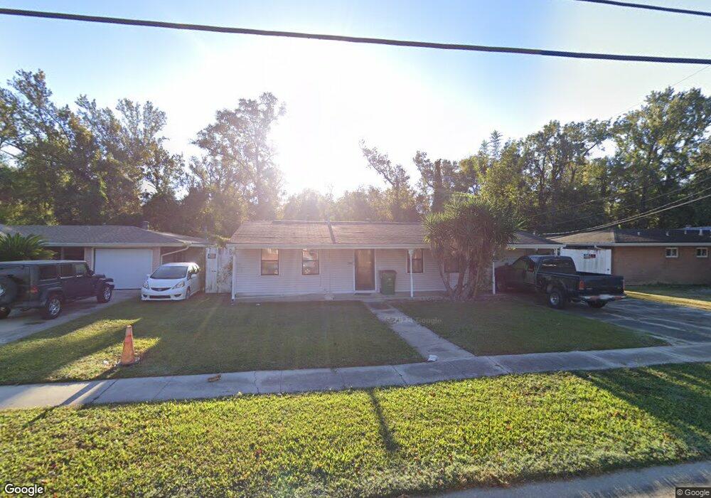
1201 Wiegand Dr Westwego, LA 70094
Estimated Value: $150,000 - $211,000
3
Beds
2
Baths
1,368
Sq Ft
$128/Sq Ft
Est. Value
About This Home
This home is located at 1201 Wiegand Dr, Westwego, LA 70094 and is currently estimated at $175,311, approximately $128 per square foot. 1201 Wiegand Dr is a home located in Jefferson Parish with nearby schools including Mildred S. Harris Elementary School, Ray St. Pierre Academy for Advanced Studies, and L.W. Higgins High School.
Ownership History
Date
Name
Owned For
Owner Type
Purchase Details
Closed on
Aug 19, 2011
Sold by
Secretary Housing Urban Dev
Bought by
Dalton Robert L
Current Estimated Value
Purchase Details
Closed on
Jun 17, 2011
Sold by
Wells Fargo Bank Na
Bought by
Secretary Housing Urban Dev
Purchase Details
Closed on
Mar 2, 2011
Sold by
Normand Sheriff Newell D and Wiley Daniel S
Bought by
Wells Fargo Bank Na
Purchase Details
Closed on
Mar 31, 2005
Sold by
Dufour Gayle
Bought by
Wiley Daniel
Home Financials for this Owner
Home Financials are based on the most recent Mortgage that was taken out on this home.
Original Mortgage
$113,223
Interest Rate
5.71%
Create a Home Valuation Report for This Property
The Home Valuation Report is an in-depth analysis detailing your home's value as well as a comparison with similar homes in the area
Home Values in the Area
Average Home Value in this Area
Purchase History
| Date | Buyer | Sale Price | Title Company |
|---|---|---|---|
| Dalton Robert L | $30,000 | -- | |
| Secretary Housing Urban Dev | $1,223 | -- | |
| Wells Fargo Bank Na | -- | -- | |
| Wiley Daniel | $115,000 | -- |
Source: Public Records
Mortgage History
| Date | Status | Borrower | Loan Amount |
|---|---|---|---|
| Previous Owner | Wiley Daniel | $113,223 |
Source: Public Records
Tax History Compared to Growth
Tax History
| Year | Tax Paid | Tax Assessment Tax Assessment Total Assessment is a certain percentage of the fair market value that is determined by local assessors to be the total taxable value of land and additions on the property. | Land | Improvement |
|---|---|---|---|---|
| 2024 | $231 | $12,500 | $3,780 | $8,720 |
| 2023 | $676 | $12,430 | $3,780 | $8,650 |
| 2022 | $1,663 | $12,430 | $3,780 | $8,650 |
| 2021 | $1,572 | $12,430 | $3,780 | $8,650 |
| 2020 | $1,562 | $12,430 | $3,780 | $8,650 |
| 2019 | $1,613 | $12,430 | $3,780 | $8,650 |
| 2018 | $599 | $12,430 | $3,780 | $8,650 |
| 2017 | $1,456 | $12,430 | $3,780 | $8,650 |
| 2016 | $1,431 | $12,430 | $3,780 | $8,650 |
| 2015 | $527 | $12,070 | $3,150 | $8,920 |
| 2014 | $527 | $12,070 | $3,150 | $8,920 |
Source: Public Records
Map
Nearby Homes
- 1120 Barnes St
- 1037 Hooter Rd
- 941 Oak Ave
- 210 Lafitte St
- 632 Wiegand Dr
- 171 11th St
- 905 N Claiborne Pkwy
- 104 Jefferson Heights Ave
- 107 Jefferson Heights Ave
- 112 Jefferson Heights Ave
- 19 Research Dr
- 4533 River Rd
- 4529 River Rd
- 4213 River Rd
- 7821 Alma St
- 204 Dodge Ave
- 136 38 Cherokee St
- 237 Vinet Ave
- 28 Broadway St
- 1125 Wiegand Dr
- 1205 Wiegand Dr
- 1121 Wiegand Dr
- 1209 Wiegand Dr
- 1200 Wiegand Dr
- 1000 Mono Ct
- 1117 Wiegand Dr
- 1213 Wiegand Dr
- 1006 Mono Ct
- 1117 Barnes St
- 1217 Wiegand Dr
- 1113 Wiegand Dr
- 1001 Mono Ct
- 1116 Wiegand Dr
- 1116 Barnes St
- 1113 Barnes St
- 1221 Wiegand Dr
- 1005 Mono Ct
- 1109 Wiegand Dr
- 1012 Mono Ct