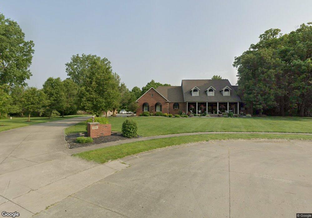
1201 Wildwood Cir Delphos, OH 45833
Estimated Value: $348,000 - $598,935
4
Beds
4
Baths
3,761
Sq Ft
$116/Sq Ft
Est. Value
About This Home
This home is located at 1201 Wildwood Cir, Delphos, OH 45833 and is currently estimated at $435,645, approximately $115 per square foot. 1201 Wildwood Cir is a home located in Van Wert County with nearby schools including Delphos St. John's High School and Delphos St. John's Elementary School.
Ownership History
Date
Name
Owned For
Owner Type
Purchase Details
Closed on
Jun 1, 2011
Sold by
Schwinnen Dean T and Schwinnen Christina M
Bought by
Schwinnen Dean T and Schwinnen Christina M
Current Estimated Value
Purchase Details
Closed on
Jan 26, 2001
Bought by
Schwinnen Dean T
Purchase Details
Closed on
Jan 17, 1995
Bought by
Dickman Kathy L
Create a Home Valuation Report for This Property
The Home Valuation Report is an in-depth analysis detailing your home's value as well as a comparison with similar homes in the area
Home Values in the Area
Average Home Value in this Area
Purchase History
| Date | Buyer | Sale Price | Title Company |
|---|---|---|---|
| Schwinnen Dean T | -- | None Available | |
| Schwinnen Dean T | $350,000 | -- | |
| Schwinnen Dean T | $350,000 | -- | |
| Dickman Kathy L | $17,000 | -- | |
| Dickman Kathy L | $17,000 | -- |
Source: Public Records
Tax History Compared to Growth
Tax History
| Year | Tax Paid | Tax Assessment Tax Assessment Total Assessment is a certain percentage of the fair market value that is determined by local assessors to be the total taxable value of land and additions on the property. | Land | Improvement |
|---|---|---|---|---|
| 2024 | $5,280 | $188,290 | $22,970 | $165,320 |
| 2023 | $5,280 | $188,290 | $22,970 | $165,320 |
| 2022 | $4,523 | $147,860 | $13,840 | $134,020 |
| 2021 | $4,539 | $147,860 | $13,840 | $134,020 |
| 2020 | $4,651 | $147,860 | $13,840 | $134,020 |
| 2019 | $3,752 | $131,380 | $13,840 | $117,540 |
| 2018 | $3,755 | $131,380 | $13,840 | $117,540 |
| 2017 | $3,779 | $131,380 | $13,840 | $117,540 |
| 2016 | $3,543 | $124,510 | $13,840 | $110,670 |
| 2015 | $3,542 | $124,510 | $13,840 | $110,670 |
| 2014 | $3,718 | $124,510 | $13,840 | $110,670 |
| 2013 | $3,695 | $116,310 | $13,840 | $102,470 |
Source: Public Records
Map
Nearby Homes
- 604 W 6th St
- 332 W 6th St
- 409 N Bredeick St
- 810 N Franklin St
- 610 N Washington St
- 704 N Franklin St
- 405 N Franklin St
- 210 E 3rd St
- 221 S Main St
- 1303 Carolyn Dr
- 1220 Rose Anna Dr
- 633 E 2nd St
- 521 Carolyn Dr
- 424 S Canal St
- 634 S Clay St
- 516 S Main St
- 483 S Franklin St
- 827 S Washington St
- 11630 Clearview Dr
- 1400 S Clay St Unit 17
- 1200 Wildwood Cir
- 1195 Wildwood Cir
- 1203 Gilliland Ave
- 1190 Wildwood Cir
- 1201 Gilliland Ave
- 1205 Gilliland Ave
- 1150 Wildwood Cir
- 1035 Gilliland Ave
- 1202 Gilliland Ave
- 1204 Gilliland Ave
- 1301 Gilliland Ave
- 1025 Gilliland Ave
- 1206 Gilliland Ave
- 1100 Wildwood Cir
- 1036 Gilliland Ave
- 1105 Wildwood Cir
- 1201 Dickman Ave
- 1026 Gilliland Ave
- 1017 Gilliland Ave
- 1205 Dickman Ave