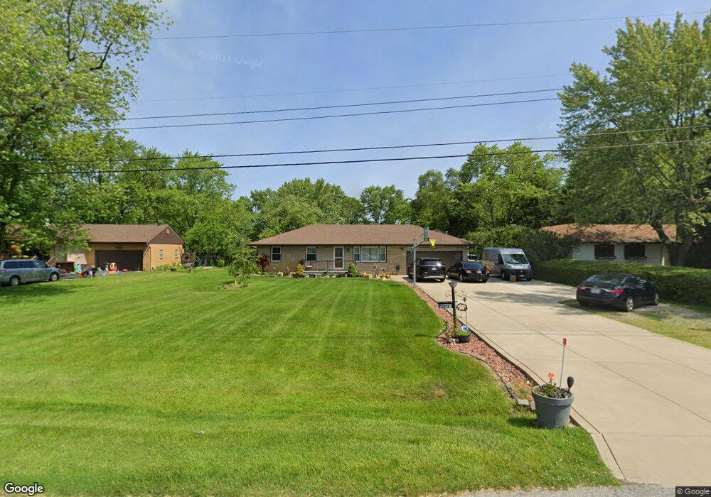
12012 79th Place Dyer, IN 46311
Hartsdale NeighborhoodEstimated Value: $266,000 - $325,358
3
Beds
2
Baths
1,053
Sq Ft
$283/Sq Ft
Est. Value
About This Home
This home is located at 12012 79th Place, Dyer, IN 46311 and is currently estimated at $298,090, approximately $283 per square foot. 12012 79th Place is a home located in Lake County with nearby schools including James H. Watson Elementary School, Michael Grimmer Middle School, and Lake Central High School.
Ownership History
Date
Name
Owned For
Owner Type
Purchase Details
Closed on
Dec 15, 2005
Sold by
Zasada John E and Meyer Zasada Sara A
Bought by
Riffe Alvin L and Riffe Wendee J
Current Estimated Value
Home Financials for this Owner
Home Financials are based on the most recent Mortgage that was taken out on this home.
Original Mortgage
$169,100
Outstanding Balance
$95,677
Interest Rate
6.48%
Mortgage Type
Fannie Mae Freddie Mac
Estimated Equity
$202,413
Create a Home Valuation Report for This Property
The Home Valuation Report is an in-depth analysis detailing your home's value as well as a comparison with similar homes in the area
Home Values in the Area
Average Home Value in this Area
Purchase History
| Date | Buyer | Sale Price | Title Company |
|---|---|---|---|
| Riffe Alvin L | -- | Ticor |
Source: Public Records
Mortgage History
| Date | Status | Borrower | Loan Amount |
|---|---|---|---|
| Open | Riffe Alvin L | $169,100 |
Source: Public Records
Tax History Compared to Growth
Tax History
| Year | Tax Paid | Tax Assessment Tax Assessment Total Assessment is a certain percentage of the fair market value that is determined by local assessors to be the total taxable value of land and additions on the property. | Land | Improvement |
|---|---|---|---|---|
| 2024 | $4,013 | $250,900 | $89,300 | $161,600 |
| 2023 | $1,949 | $243,000 | $93,000 | $150,000 |
| 2022 | $1,949 | $234,300 | $93,000 | $141,300 |
| 2021 | $1,762 | $222,000 | $93,000 | $129,000 |
| 2020 | $1,785 | $219,100 | $69,600 | $149,500 |
| 2019 | $1,907 | $211,500 | $46,400 | $165,100 |
| 2018 | $1,880 | $207,600 | $46,400 | $161,200 |
| 2017 | $1,783 | $209,000 | $46,400 | $162,600 |
| 2016 | $1,388 | $181,300 | $46,400 | $134,900 |
| 2014 | $1,230 | $176,500 | $46,400 | $130,100 |
| 2013 | $1,210 | $173,700 | $46,400 | $127,300 |
Source: Public Records
Map
Nearby Homes
- 8066 Northcote Ct
- 1444 Madelene Grace Ct
- 2509 Ashley Ave
- 2438 Braeburn Place
- 11401 W 78th Ct
- 11825 Heron Lake Rd
- 8262 Heron Lake Rd
- 2916 Amberleigh Ln
- 8407 Heron Lake Rd
- 839 Sunset Dr
- 2557 Howard Castle Dr
- 12680 Rosewood Ct
- 2238 Meadow Ln
- 2218 Meadow Ln
- 716 Moraine Trace Unit 3
- 8250 Columbia Ave
- 12750 Goldenrod Place
- 2411 Canterbury Place
- 8080 Us Highway 41
- 1429 W Lincoln Hwy
- 12008 79th Place
- 12100 79th Place
- 12108 79th Place
- 12013 79th Place
- 12000 79th Place
- 12101 79th Place
- 12009 79th Place
- 12112 79th Place
- 1227 Bemis Heights Ave
- 1235 Bemis Heights Ave
- 1223 Bemis Heights Ave
- 12105 79th Place
- 12005 79th Place
- 1241 Bemis Heights Ave
- 1217 Bemis Heights Ave
- 1211 Bemis Heights Ave
- 1247 Bemis Heights Ave
- 12109 79th Place
- 12200 79th Place
- 12001 79th Place