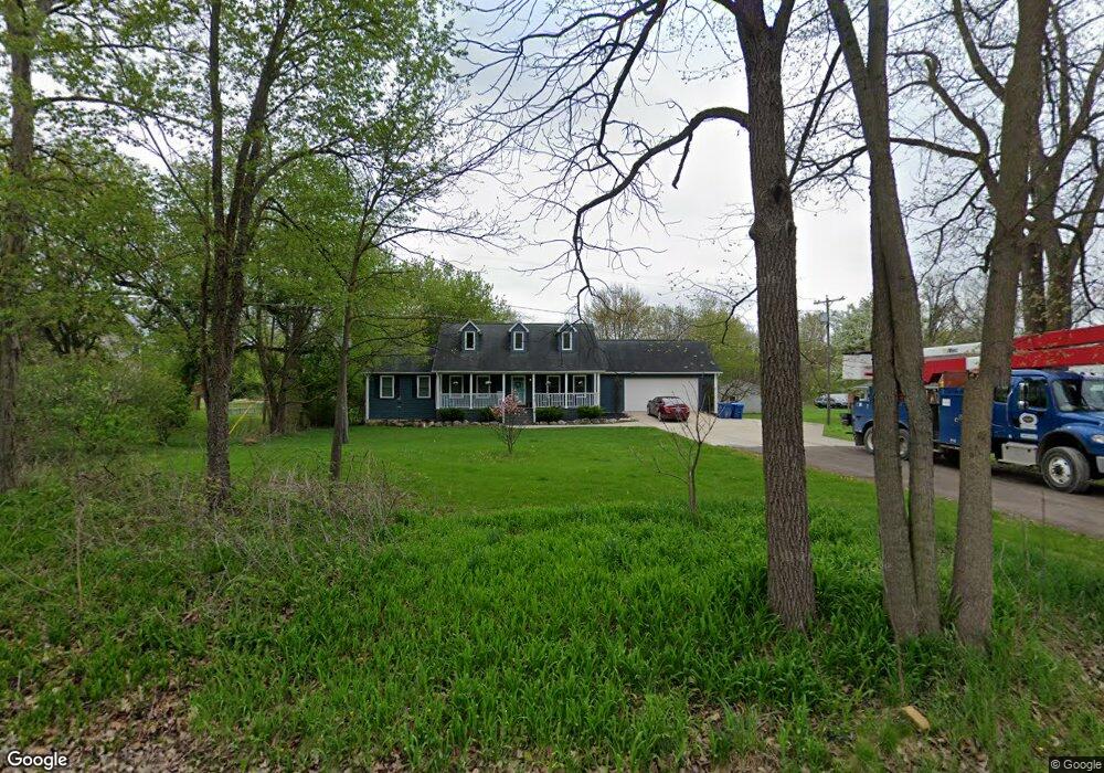
12015 Sharp Rd Linden, MI 48451
Estimated Value: $326,000 - $491,000
3
Beds
2
Baths
1,470
Sq Ft
$269/Sq Ft
Est. Value
About This Home
This home is located at 12015 Sharp Rd, Linden, MI 48451 and is currently estimated at $394,710, approximately $268 per square foot. 12015 Sharp Rd is a home located in Genesee County with nearby schools including Linden Elementary School, Linden Middle School, and Linden High School.
Ownership History
Date
Name
Owned For
Owner Type
Purchase Details
Closed on
Sep 17, 2020
Sold by
Bryan Timothy H and Bryan Amber G
Bought by
Page Cameron Robert
Current Estimated Value
Home Financials for this Owner
Home Financials are based on the most recent Mortgage that was taken out on this home.
Original Mortgage
$255,550
Outstanding Balance
$226,363
Interest Rate
2.8%
Mortgage Type
New Conventional
Estimated Equity
$168,347
Purchase Details
Closed on
Jun 22, 2007
Sold by
Fannie Mae
Bought by
Bryan Timothy H and Bryan Amber G
Purchase Details
Closed on
Oct 27, 2006
Sold by
Mortgage Electronic Registration Systems
Bought by
Federal National Mortgage Association
Purchase Details
Closed on
Oct 18, 2006
Sold by
Quasarano Leonard P and Quasarano Heather A
Bought by
Mortgage Electronic Registration Systems
Create a Home Valuation Report for This Property
The Home Valuation Report is an in-depth analysis detailing your home's value as well as a comparison with similar homes in the area
Home Values in the Area
Average Home Value in this Area
Purchase History
| Date | Buyer | Sale Price | Title Company |
|---|---|---|---|
| Page Cameron Robert | $269,000 | Cislo Title Company | |
| Bryan Timothy H | $150,000 | Guaranty Title Company | |
| Federal National Mortgage Association | -- | None Available | |
| Mortgage Electronic Registration Systems | $162,680 | None Available |
Source: Public Records
Mortgage History
| Date | Status | Borrower | Loan Amount |
|---|---|---|---|
| Open | Page Cameron Robert | $255,550 |
Source: Public Records
Tax History
| Year | Tax Paid | Tax Assessment Tax Assessment Total Assessment is a certain percentage of the fair market value that is determined by local assessors to be the total taxable value of land and additions on the property. | Land | Improvement |
|---|---|---|---|---|
| 2025 | $5,088 | $170,700 | $0 | $0 |
| 2024 | $2,390 | $165,400 | $0 | $0 |
| 2023 | $2,252 | $148,600 | $0 | $0 |
| 2022 | $3,872 | $135,700 | $0 | $0 |
| 2021 | $5,611 | $129,000 | $0 | $0 |
| 2020 | $1,462 | $125,300 | $0 | $0 |
| 2019 | $1,468 | $114,400 | $0 | $0 |
| 2018 | $3,079 | $105,100 | $0 | $0 |
| 2017 | $2,894 | $106,000 | $0 | $0 |
| 2016 | $2,943 | $99,200 | $0 | $0 |
| 2015 | $2,981 | $94,300 | $0 | $0 |
| 2014 | $1,360 | $88,100 | $0 | $0 |
| 2012 | -- | $81,700 | $81,700 | $0 |
Source: Public Records
Map
Nearby Homes
- 12521 Sharp Rd
- 6044 Lahring Rd
- 6030 Lahring Rd
- 5528 Lahring Rd
- 13150 Westwinds Dr
- 13180 Westwinds Dr
- 13168 Westwinds Dr
- 13138 Westwinds Dr
- 13102 Westwinds Dr
- 13096 Westwinds Dr
- 13147 Westwinds Dr
- 13132 Westwinds Dr
- 13174 Westwinds Dr
- 13126 Westwinds Dr
- 13175 Westwinds Dr
- 13107 Stony Brook Pass
- 13187 Westwinds Dr
- 13158 Stony Brook Pass
- 13108 River Rock Pass Unit 99
- 13318 Westwinds Dr
Your Personal Tour Guide
Ask me questions while you tour the home.