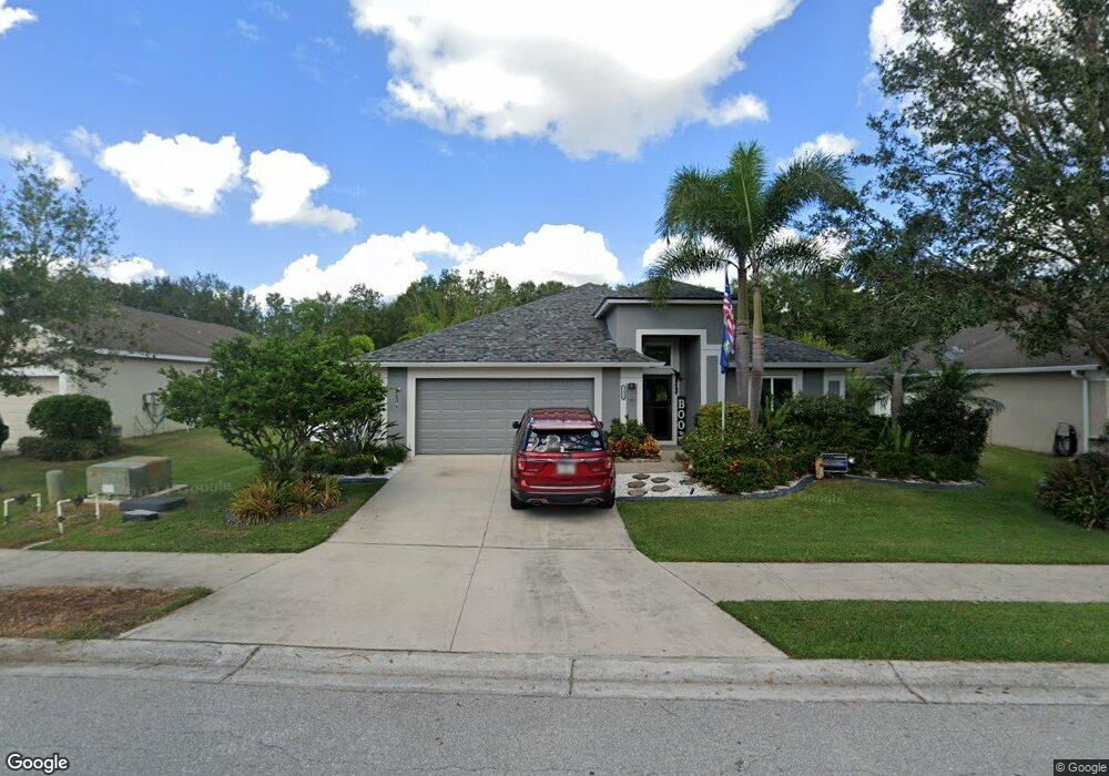
12018 56th St E Parrish, FL 34219
Estimated Value: $355,000 - $468,000
4
Beds
2
Baths
2,021
Sq Ft
$202/Sq Ft
Est. Value
About This Home
This home is located at 12018 56th St E, Parrish, FL 34219 and is currently estimated at $407,248, approximately $201 per square foot. 12018 56th St E is a home located in Manatee County with nearby schools including Annie Lucy Williams Elementary School, Buffalo Creek Middle School, and Parrish Community High School.
Ownership History
Date
Name
Owned For
Owner Type
Purchase Details
Closed on
Jun 11, 2010
Sold by
K Hovnanian Windward Homes Llc
Bought by
Phillips Keith Darin and Phillips Sharyl Lynn
Current Estimated Value
Home Financials for this Owner
Home Financials are based on the most recent Mortgage that was taken out on this home.
Original Mortgage
$190,628
Outstanding Balance
$129,502
Interest Rate
5.25%
Mortgage Type
FHA
Estimated Equity
$277,746
Create a Home Valuation Report for This Property
The Home Valuation Report is an in-depth analysis detailing your home's value as well as a comparison with similar homes in the area
Home Values in the Area
Average Home Value in this Area
Purchase History
| Date | Buyer | Sale Price | Title Company |
|---|---|---|---|
| Phillips Keith Darin | $194,200 | First American Title Ins Co |
Source: Public Records
Mortgage History
| Date | Status | Borrower | Loan Amount |
|---|---|---|---|
| Open | Phillips Keith Darin | $190,628 |
Source: Public Records
Tax History
| Year | Tax Paid | Tax Assessment Tax Assessment Total Assessment is a certain percentage of the fair market value that is determined by local assessors to be the total taxable value of land and additions on the property. | Land | Improvement |
|---|---|---|---|---|
| 2025 | $2,070 | $176,566 | -- | -- |
| 2024 | $2,070 | $171,590 | -- | -- |
| 2023 | $2,070 | $166,592 | $0 | $0 |
| 2022 | $2,001 | $161,740 | $0 | $0 |
| 2021 | $5,280 | $155,068 | $0 | $0 |
| 2020 | $1,872 | $152,927 | $0 | $0 |
| 2019 | $1,833 | $149,489 | $0 | $0 |
| 2018 | $1,807 | $146,702 | $0 | $0 |
| 2017 | $1,667 | $143,685 | $0 | $0 |
| 2016 | $1,657 | $140,730 | $0 | $0 |
| 2015 | $1,681 | $139,752 | $0 | $0 |
| 2014 | $1,681 | $138,643 | $0 | $0 |
| 2013 | $1,674 | $136,594 | $19,500 | $117,094 |
Source: Public Records
Map
Nearby Homes
- 5405 120th Ave E
- 5319 120th Ave E
- 11880 Us Highway 301 N
- 5315 119th Terrace E
- 11814 53rd Ct E
- 5220 119th Terrace E
- 12355 Doris Rd
- 11742 Hidden Forest Loop
- 12622 Tahitian Pearl Cir
- 12028 Blue Diamond Trail
- 10661 Spring Tide Way
- 9024 Barrier Coast Trail
- 11906 Lilac Pearl Ln
- 12219 Violet Jasper Dr
- 12207 Violet Jasper Dr
- 12712 Tahitian Pearl Cir
- 11770 Hidden Forest Loop
- 5030 123rd Ave E
- 5311 124th Ave E
- 5018 123rd Ave E
- 12014 56th St E
- 12022 56th St E
- 12104 56th St E
- 12010 56th St E
- 12011 56th St E
- 12015 56th St E
- 12019 56th St E
- 12108 56th St E
- 12006 56th St E
- 12103 56th St E
- 12103 Street E
- 11955 56th St E
- 5536 120th Ave E
- 12107 56th St E
- 12112 56th St E
- 11954 56th St E
- 11951 56th St E
- 5535 120th Ave E
- 12111 56th St E
- 5530 120th Ave E
Your Personal Tour Guide
Ask me questions while you tour the home.